File:Map_Crusader_states_1135-it.png
From Wikipedia, the free encyclopedia
Size of this preview: 441 × 600 pixels. Other resolutions: 176 × 240 pixels | 353 × 480 pixels | 978 × 1,330 pixels.
Original file (978 × 1,330 pixels, file size: 299 KB, MIME type: image/png)
| This is a file from the Wikimedia Commons. Information from its description page there is shown below. Commons is a freely licensed media file repository. You can help. |
Summary
| DescriptionMap Crusader states 1135-it.png |
[edit]
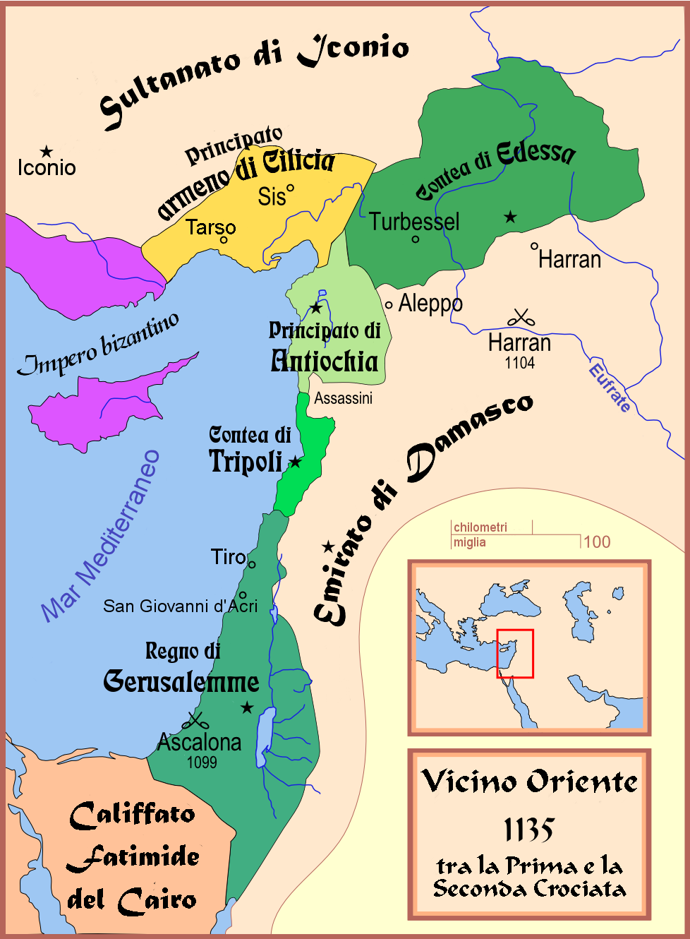
Čeština: Politická mapa Blízkého východu v roce 1135. Deutsch: Die Levante, 1135, zwischen den Ersten und Zweiten Kreuzzügen. Kreuzzugsstaaten sind mit einem roten Kreuz gekennzeichnet Eesti: Lähis-Ida (1135) Español: Oriente Próximo en 1135, entre la primera y segunda cruzadas. Esperanto: Politika mapo de Levantenio dum 1135, inter la krucmilitaroj unuaj kaj duaj. Français : Carte politique du Proche-Orient en 1135, entre la Première et la Seconde Croisades. les États latins d'Orient sont marqués d'une croix rouge. Galego: Mapa dos estados cruzados en Próximo Oriente polo 1135. Italiano: Carta politica del Vicino Oriente nel 1135. Magyar: A Közel-Kelet térképe 1135-ben. Polski: Mapa polityczna Bliskiego Wschodu w roku 1135, w okresie II krucjaty. Ελληνικά: Πολιτικός χάρτης της Μέσης Ανατολής το 1135, ανάμεσα στην πρώτη και τη δεύτερη Σταυροφορία Македонски: Политичка карта на Блискиот Исток во 1135 г. Крстоносните држави се означени со црвени крстови. Русский: Карта Ближнего Востока в 1135 г. Српски / srpski: Politička karta Bliskog Istoka 1135. godine, između Prvog i Drugog krstaškog pohoda. Krstaške države su označene crvenim krstom. ქართული: ახლო აღმოსავლეთი 1135 წელს ไทย: แผนที่ตะวันออกกลาง (คศ. 1135) ระหว่างครูเสดครั้งที่ 1 และครั่งที่ 2 中文: 一副关于1135年近东地区局势的地图,标注红色十字的为十字军国家 العربية : الدويلات الصليبية والدول الإسلامية المجاورة لها في الفترة بين الحملتين الصليبيتين الأولى والثانية. فارسی : نسخه فارسی No description.
|
||||||||||||||
| Date | |||||||||||||||
| Source |
Opera creata dall'uploader (own work by uploader) |
||||||||||||||
| Author | MapMaster; traduzione: Franco aq | ||||||||||||||
| Other versions |
[edit]
See also |
||||||||||||||


-ka.png)


Licensing
I, the copyright holder of this work, hereby publish it under the following license:

|
Permission is granted to copy, distribute and/or modify this document under the terms of the GNU Free Documentation License, Version 1.2 or any later version published by the Free Software Foundation; with no Invariant Sections, no Front-Cover Texts, and no Back-Cover Texts. A copy of the license is included in the section entitled GNU Free Documentation License.http://www.gnu.org/copyleft/fdl.htmlGFDLGNU Free Documentation Licensetruetrue |
| This file is licensed under the Creative Commons Attribution-Share Alike 3.0 Unported license. | ||
| ||
| This licensing tag was added to this file as part of the GFDL licensing update.http://creativecommons.org/licenses/by-sa/3.0/CC BY-SA 3.0Creative Commons Attribution-Share Alike 3.0truetrue |
Captions
Add a one-line explanation of what this file represents
Items portrayed in this file
depicts
11 August 2008
File history
Click on a date/time to view the file as it appeared at that time.
| Date/Time | Thumbnail | Dimensions | User | Comment | |
|---|---|---|---|---|---|
| current | 18:33, 11 August 2008 | | 978 × 1,330 (299 KB) | Franco aq | {{Information |Description= |Source= |Date= |Author= |Permission= |other_versions= }} |
| 22:14, 10 August 2008 |  | 978 × 1,330 (298 KB) | Franco aq | {{Information |Description={{en|1={{en|A political map of the w:en:Near East in 1135 CE.}}}} |Source=Opera creata dall'uploader (own work by uploader) |Author=Franco aq |Date= |Permission= |other_versions= }} {{ |
File usage
No pages on the English Wikipedia use this file (pages on other projects are not listed).
Global file usage
The following other wikis use this file:
- Usage on it.wikipedia.org
- Prima crociata
- Edessa (Mesopotamia)
- Seconda crociata
- Costanza d'Antiochia
- Principato d'Antiochia
- Stato crociato
- Regno di Gerusalemme
- Folco V d'Angiò
- Norandino
- Contea di Tripoli
- Leone I d'Armenia
- Basso Medioevo
- Buridi
- Assedio di Tiro (1124)
- Melisenda di Gerusalemme
- Guerre bizantino-selgiuchidi
- Pactum Warmundi
- Medioevo
- Taj al-Muluk Buri
- Alice di Antiochia
- Cavalieri templari
- Progetto:Laboratorio grafico/Immagini da migliorare/Archivio risolte/71
- Giovanni di Ibelin
- Storia del cristianesimo in età medievale
- Fondachi italiani nel Mar Mediterraneo e nel Mar Nero
- Vassalli del Regno di Gerusalemme
- Usage on la.wikipedia.org
- Usage on lij.wikipedia.org
Retrieved from "https://en.wikipedia.org/wiki/File:Map_Crusader_states_1135-it.png"