File:Manchester_Metrolink_-_Schemaplan.png
From Wikipedia, the free encyclopedia
Size of this preview: 800 × 197 pixels. Other resolutions: 320 × 79 pixels | 640 × 158 pixels | 1,024 × 252 pixels | 3,550 × 874 pixels.
Original file (3,550 × 874 pixels, file size: 323 KB, MIME type: image/png)
| This is a file from the Wikimedia Commons. Information from its description page there is shown below. Commons is a freely licensed media file repository. You can help. |
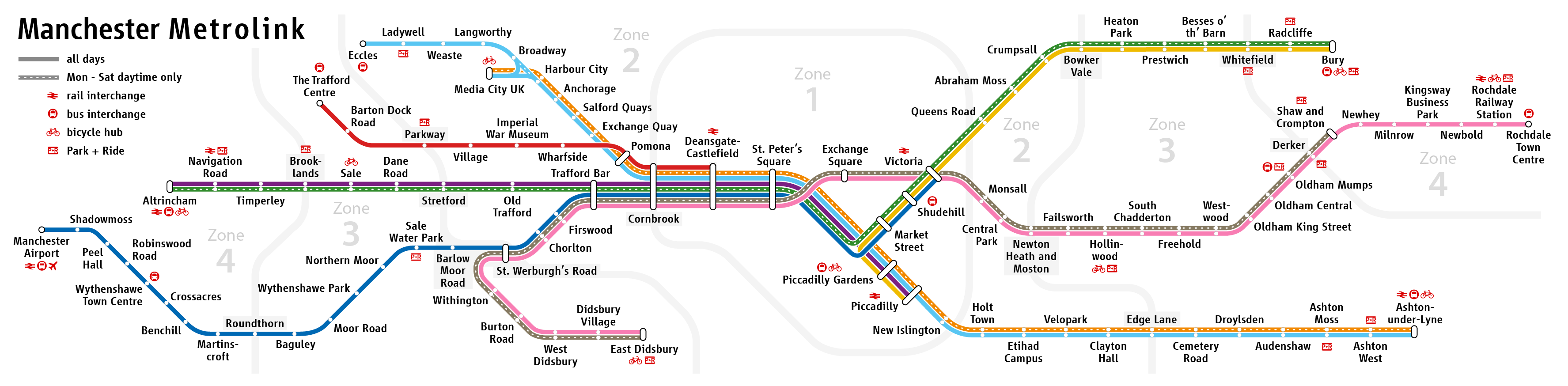
| DescriptionManchester Metrolink - Schemaplan.png |
|
| Date | see file history |
| Source | Own work |
| Author | Maximilian Dörrbecker (Chumwa) |
| Permission (Reusing this file) |
This file is licensed under the Creative Commons Attribution-Share Alike 2.0 Generic license.
|
| Other versions |
|


|
This transport map image could be re-created using vector graphics as an SVG file. This has several advantages; see Commons:Media for cleanup for more information. If an SVG form of this image is available, please upload it and afterwards replace this template with
{{vector version available|new image name}}.
It is recommended to name the SVG file “Manchester Metrolink - Schemaplan.svg”—then the template Vector version available (or Vva) does not need the new image name parameter. |
Captions
Add a one-line explanation of what this file represents
Items portrayed in this file
depicts
image/png
File history
Click on a date/time to view the file as it appeared at that time.
| Date/Time | Thumbnail | Dimensions | User | Comment | |
|---|---|---|---|---|---|
| current | 19:28, 22 May 2024 | 3,550 × 874 (323 KB) | Delusion23 | Update: Trafford Centre line now runs to Deansgate | |
| 20:08, 4 February 2021 | 3,550 × 874 (322 KB) | Delusion23 | "intu Trafford Centre" has been renamed "The Trafford Centre" | ||
| 08:56, 13 June 2020 | 3,550 × 874 (298 KB) | Chumwa | updated Etihad Campus too | ||
| 08:53, 13 June 2020 | 3,550 × 874 (298 KB) | Chumwa | update on base of original map version | ||
| 19:15, 1 April 2020 | 3,550 × 874 (322 KB) | Delusion23 | Zone boundary stations like Parkway and Stretford have grey background behind text | ||
| 13:23, 31 March 2020 | 3,550 × 874 (346 KB) | G-13114 | Further small improvements | ||
| 11:54, 31 March 2020 | 3,550 × 874 (346 KB) | G-13114 | Further minor tweaks | ||
| 11:33, 31 March 2020 | 3,550 × 874 (346 KB) | G-13114 | Some small tweaks and tidying | ||
| 11:24, 31 March 2020 | 3,550 × 874 (346 KB) | G-13114 | Tidy the junction arrangement around Pomona/Cornbrook to show TPL terminating on the outside rather than inside. | ||
| 20:30, 30 March 2020 | 3,550 × 874 (324 KB) | Delusion23 | Further tidying |
File usage
The following pages on the English Wikipedia use this file (pages on other projects are not listed):
Global file usage
The following other wikis use this file:
- Usage on de.wikipedia.org
- Usage on de.wikivoyage.org
- Usage on en.wikivoyage.org
- Usage on eo.wikipedia.org
- Usage on es.wikipedia.org
- Usage on fa.wikipedia.org
- Usage on ja.wikipedia.org
- Usage on no.wikipedia.org
- Usage on uk.wikipedia.org
- Usage on www.wikidata.org
- Usage on zh.wikipedia.org
Metadata
This file contains additional information, probably added from the digital camera or scanner used to create or digitize it.
If the file has been modified from its original state, some details may not fully reflect the modified file.
| Horizontal resolution | 78.72 dpc |
|---|---|
| Vertical resolution | 78.72 dpc |
| Software used |