File:Maluku_Islands_en.png
From Wikipedia, the free encyclopedia
Size of this preview: 544 × 599 pixels. Other resolutions: 218 × 240 pixels | 436 × 480 pixels | 697 × 768 pixels | 930 × 1,024 pixels | 1,489 × 1,640 pixels.
Original file (1,489 × 1,640 pixels, file size: 1.08 MB, MIME type: image/png)
| This is a file from the Wikimedia Commons. Information from its description page there is shown below. Commons is a freely licensed media file repository. You can help. |
Summary
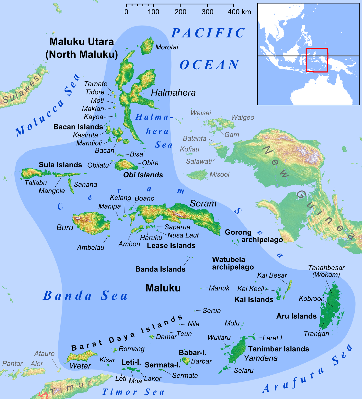
| DescriptionMaluku Islands en.png |
English: Map of Maluku Islands |
||
| Date | |||
| Source |
own work, used: |
||
| Author | Lencer | ||
| Other versions |
|


|
This map has been made or improved in the German Kartenwerkstatt (Map Lab). You can propose maps to improve as well.
azərbaycanca ∙ čeština ∙ Deutsch ∙ Deutsch (Sie-Form) ∙ English ∙ español ∙ français ∙ italiano ∙ latviešu ∙ magyar ∙ Nederlands ∙ Plattdüütsch ∙ polski ∙ português ∙ română ∙ sicilianu ∙ slovenščina ∙ suomi ∙ македонски ∙ русский ∙ ქართული ∙ հայերեն ∙ বাংলা ∙ ไทย ∙ +/−
|
Licensing
I, the copyright holder of this work, hereby publish it under the following license:
This file is licensed under the Creative Commons Attribution-Share Alike 3.0 Unported license.
- You are free:
- to share – to copy, distribute and transmit the work
- to remix – to adapt the work
- Under the following conditions:
- attribution – You must give appropriate credit, provide a link to the license, and indicate if changes were made. You may do so in any reasonable manner, but not in any way that suggests the licensor endorses you or your use.
- share alike – If you remix, transform, or build upon the material, you must distribute your contributions under the same or compatible license as the original.
-
Captions
Add a one-line explanation of what this file represents
Items portrayed in this file
depicts
February 2013
File history
Click on a date/time to view the file as it appeared at that time.
| Date/Time | Thumbnail | Dimensions | User | Comment | |
|---|---|---|---|---|---|
| current | 13:52, 26 February 2018 | | 1,489 × 1,640 (1.08 MB) | Sebastian Wallroth | Removed border by cropping 1 % horizontally and 1 % vertically using CropTool with precise mode. |
| 13:04, 28 March 2013 |  | 1,499 × 1,650 (1.09 MB) | Lencer | + Kayoa | |
| 18:10, 24 March 2013 |  | 1,499 × 1,650 (1.09 MB) | Lencer | + Manuk, + Serua, + Teun, Haruku fixed | |
| 09:45, 12 February 2013 |  | 1,500 × 1,651 (1.09 MB) | Lencer | + Lease Islands | |
| 15:29, 11 February 2013 |  | 1,500 × 1,651 (1.08 MB) | Lencer | == {{int:filedesc}} == {{Information |Description= {{en|Map of Maluku Islands}} |Source=own work, used: * Maluku Locator Topography.png by User:Sadalmelik |Date=2013-02 |Author=[[User:L... |
File usage
The following pages on the English Wikipedia use this file (pages on other projects are not listed):
- Amahai
- Ambon Island
- Ariate
- Atiahu
- Babar Islands
- Bacan Islands
- Banda Islands
- Banda Sea
- Barat Daya Islands
- Bemu
- Bengoi
- Bula, Indonesia
- Central Halmahera Regency
- Damar Island
- Dukono
- Dumatubin Airport
- East Halmahera Regency
- Gamalama
- Gebe
- Gorong archipelago
- Gunungapi Wetar
- Halmahera Sea
- Haria, Saparua
- Haruku Island
- Hila, Ambon
- Kai Besar
- Kai Islands
- Kai Kecil
- Kairatu
- Kao, Indonesia
- Kayoa
- Kelang
- Kisar
- Koba Island
- Kobroor
- Kola Island
- Kulur, Indonesia
- Kur Island
- Labuha
- Larike
- Layoni, Indonesia
- Lease Islands
- Leti (island)
- Letti Islands
- Liran
- Loki, Indonesia
- Lonthoir
- Lucipara Islands
- Luhu, Indonesia
- Maikoor
- Makian
- Maluku (province)
- Maluku Islands
- Manipa
- Manuk
- Mdona Hyera
- Moa (island)
- Mount Binaiya
- Mount Kapalatmada
- Mount Nila
- Mount Serua
- Mount Teon
- Mount Wurlali
- Namniwel Airport
- Namrole Airport
- Naval Base Borneo
- Nieuwerkerk (volcano)
- Nyata
- Obi (island)
- Obi Islands
- Paperu
- Penyu Islands
- Phalaenopsis robinsonii
- Piru, Indonesia
- Romang (island)
- Saparua
- Saunulu
- Selaru
- Seram Sea
- Soasiu
- Tanahbesar
- Taniwel
- Tayandu Islands
- Teor (island)
- Trangan
- Tulehu
- Watubela archipelago
- Weber Deep
- Wetar
- Yaputih
- Template:Maluku-geo-stub
Global file usage
The following other wikis use this file:
- Usage on ace.wikipedia.org
- Usage on af.wikipedia.org
- Usage on ar.wikipedia.org
- Usage on ast.wikipedia.org
- Usage on az.wikipedia.org
- Usage on ba.wikipedia.org
- Usage on bcl.wikipedia.org
- Usage on bg.wikipedia.org
- Usage on bm.wikipedia.org
- Usage on bn.wikipedia.org
- Usage on ca.wikipedia.org
- Usage on ceb.wikipedia.org
- Usage on cs.wikipedia.org
View more global usage of this file.
Metadata
This file contains additional information, probably added from the digital camera or scanner used to create or digitize it.
If the file has been modified from its original state, some details may not fully reflect the modified file.
| Horizontal resolution | 83.46 dpc |
|---|---|
| Vertical resolution | 83.46 dpc |
| Software used |
Retrieved from "https://en.wikipedia.org/wiki/File:Maluku_Islands_en.png"