File:Madrid-metro-map.png
From Wikipedia, the free encyclopedia
Original file (1,000 × 1,420 pixels, file size: 204 KB, MIME type: image/png)
| This is a file from the Wikimedia Commons. Information from its description page there is shown below. Commons is a freely licensed media file repository. You can help. |
 | This image was previously a featured picture, but community consensus determined that it no longer meets our featured-picture criteria. If you have a high-quality image that you believe meets the criteria, be sure to upload it, using the proper free-license tag, then add it to a relevant article and nominate it. |
| This image was selected as picture of the day on the English Wikipedia for July 7, 2004, and May 15, 2005. |
| A vector version of this image is also available, and should be used in place of this raster image where the raster image contains information that could be stored more efficiently and/or accurately in the SVG format, as a vector graphic.
If its license requires the preservation of attribution or revision history, the raster version of this image should not be deleted, in order to maintain this information. For more information, see the documentation on MediaWiki's support of SVG images. |  |

|
File:Madrid Metro Map.svg is a vector version of this file. It should be used in place of this PNG file when not inferior.
File:Madrid-metro-map.png → File:Madrid Metro Map.svg
For more information, see Help:SVG.
|
|
|
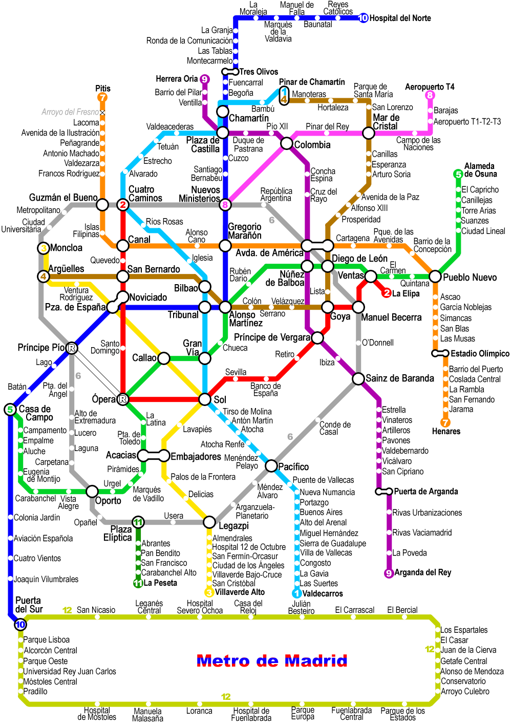
Improved version of the previous Madrid metro map, also by Montrealais. Versión amejorada del plano anterior del metro de Madrid, igualmente por Montrealais.
- You are free:
- to share – to copy, distribute and transmit the work
- to remix – to adapt the work
- Under the following conditions:
- attribution – You must give appropriate credit, provide a link to the license, and indicate if changes were made. You may do so in any reasonable manner, but not in any way that suggests the licensor endorses you or your use.
- share alike – If you remix, transform, or build upon the material, you must distribute your contributions under the same or compatible license as the original.
Other versions
| Annotations InfoField | This image is annotated: View the annotations at Commons |
Эти остановки закрыты на вечер
Captions
Items portrayed in this file
depicts
File history
Click on a date/time to view the file as it appeared at that time.
| Date/Time | Thumbnail | Dimensions | User | Comment | |
|---|---|---|---|---|---|
| current | 15:20, 24 February 2010 | | 1,000 × 1,420 (204 KB) | Dcoetzee | Remove visible watermark with copyright, attribution, disclaimer |
| 20:32, 13 January 2008 |  | 1,000 × 1,420 (208 KB) | Mahahahaneapneap | pngcrushed | |
| 14:23, 25 May 2007 |  | 1,000 × 1,420 (316 KB) | Montrealais | {{Information |Description=Madrid metro map updated to 25 May 2007 |Source=self-made |Date=25 May 2007 |Author= User:Montrealais }} | |
| 06:48, 12 April 2007 |  | 1,000 × 1,280 (281 KB) | Montrealais | update | |
| 19:11, 5 April 2007 |  | 1,000 × 1,280 (277 KB) | Montrealais | update - line 1 to Chamartín. | |
| 22:16, 29 March 2007 |  | 1,000 × 1,280 (275 KB) | Montrealais | updated to March 2007 | |
| 14:14, 22 December 2006 |  | 1,000 × 1,280 (174 KB) | Mahahahaneapneap | pngcrushed | |
| 21:38, 30 August 2006 |  | 1,000 × 1,280 (265 KB) | Montrealais | {{Information |Description=Map of the w:Madrid Metro - improved version of previous by same author. Plano del w:es:Metro de Madrid; versión amejorada de la previa por el mismo autor. |Source=Own work; licensed version of a map created for my we | |
| 14:10, 15 January 2005 |  | 800 × 1,483 (107 KB) | Jcornelius | Madrid metro map. Version of a map I drew that will eventually appear on my website, http://www.metrodemontreal.com/ . Drawn by Montrealais {{GFDL]] |
File usage
- User:Conservativegbd
- User:Cyde/Featured pictures
- User:Montrealais/Metro maps
- Wikipedia:Featured picture candidates/May-2004
- Wikipedia:Featured picture candidates/delist/2007
- Wikipedia:Featured picture candidates/delist/2010
- Wikipedia:Featured picture candidates/delist/File:Madrid-metro-map.png
- Wikipedia:Featured picture candidates/delist/Image:Madrid-metro-map.png
- Wikipedia:Graphics Lab/Resources/Draw topological maps
- Wikipedia:POTD/May 15, 2005
- Wikipedia:Picture of the day/July 2004
- Wikipedia:Picture of the day/May 15, 2005
- Wikipedia:Picture of the day/May 2005
- Wikipedia talk:WikiProject Spain/Archive 7
- Template:POTD/2004-07-07
- Template:Pic of the day/Archive1
- Portal:Maps/Selected picture
- Portal:Maps/Selected picture/26
- Portal talk:Spain
Global file usage
The following other wikis use this file:
- Usage on de.wikivoyage.org
- Usage on fr.wikipedia.org
- Usage on hu.wikipedia.org
- Usage on pl.wikipedia.org
- Usage on ru.wikipedia.org
Metadata
This file contains additional information, probably added from the digital camera or scanner used to create or digitize it.
If the file has been modified from its original state, some details may not fully reflect the modified file.
| Horizontal resolution | 39.37 dpc |
|---|---|
| Vertical resolution | 39.37 dpc |