File:LuxembourgOMCmap.png
From Wikipedia, the free encyclopedia
Size of this preview: 494 × 599 pixels. Other resolutions: 198 × 240 pixels | 395 × 480 pixels | 974 × 1,182 pixels.
Original file (974 × 1,182 pixels, file size: 27 KB, MIME type: image/png)
| This is a file from the Wikimedia Commons. Information from its description page there is shown below. Commons is a freely licensed media file repository. You can help. |
Summary
| DescriptionLuxembourgOMCmap.png |
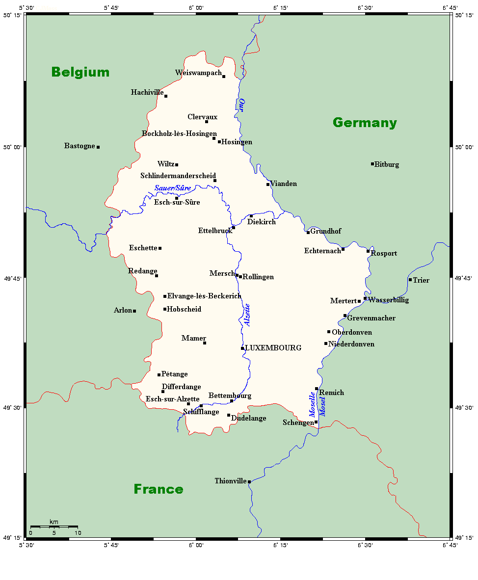
English: A map showing towns and rivers in Luxembourg, along with nearby areas. |
| Date | 18 July 2007 (original upload date) |
| Source | This map's source is here, with the uploader's modifications, and the GMT homepage says that the tools are released under the GNU General Public License. |
| Author | Kelisi at English Wikipedia |
Licensing
Kelisi at the English-language Wikipedia, the copyright holder of this work, hereby publishes it under the following license:
| This file is licensed under the Creative Commons Attribution-Share Alike 3.0 Unported license. Subject to disclaimers. | ||
| Attribution: Kelisi at the English-language Wikipedia | ||
| ||
| This licensing tag was added to this file as part of the GFDL licensing update.http://creativecommons.org/licenses/by-sa/3.0/CC BY-SA 3.0Creative Commons Attribution-Share Alike 3.0truetrue |

|
Permission is granted to copy, distribute and/or modify this document under the terms of the GNU Free Documentation License, Version 1.2 or any later version published by the Free Software Foundation; with no Invariant Sections, no Front-Cover Texts, and no Back-Cover Texts. A copy of the license is included in the section entitled GNU Free Documentation License. Subject to disclaimers.http://www.gnu.org/copyleft/fdl.htmlGFDLGNU Free Documentation Licensetruetrue |
The map has been created with the Generic Mapping Tools: https://www.generic-mapping-tools.org/ using one or more of these public-domain datasets for the relief:
বাংলা ∙ English ∙ español ∙ français ∙ italiano ∙ 日本語 ∙ македонски ∙ sicilianu ∙ 中文(简体) ∙ 中文(繁體) ∙ +/− |

|
Permission is granted to copy, distribute and/or modify this document under the terms of the GNU Free Documentation License, Version 1.2 or any later version published by the Free Software Foundation; with no Invariant Sections, no Front-Cover Texts, and no Back-Cover Texts. A copy of the license is included in the section entitled GNU Free Documentation License.http://www.gnu.org/copyleft/fdl.htmlGFDLGNU Free Documentation Licensetruetrue |
| This file is licensed under the Creative Commons Attribution-Share Alike 3.0 Unported license. | ||
| ||
| This licensing tag was added to this file as part of the GFDL licensing update.http://creativecommons.org/licenses/by-sa/3.0/CC BY-SA 3.0Creative Commons Attribution-Share Alike 3.0truetrue |
Original upload log
Transferred from en.wikipedia to Commons by Quadell using CommonsHelper.
The original description page was here. All following user names refer to en.wikipedia.
- 2008-07-09 18:53 Kelisi 974×1182× (27680 bytes) Same, but with River Alzette. Same source, same author (me), same licence.
- 2008-07-08 20:26 Kelisi 974×1130× (26247 bytes) Same author, same source, same licence. So there.
- 2007-08-04 16:02 Kelisi 544×576× (15189 bytes) a small place, but one of some significance
- 2007-07-18 20:55 Kelisi 539×576× (15003 bytes) A map showing towns and rivers in Luxembourg, along with nearby areas. This map's source is [http://www.aquarius.ifm-geomar.de/ here], with the uploader's modifications, and the [http://gmt.soest.hawaii.edu/ GMT homepage] says that the tools
Captions
Add a one-line explanation of what this file represents
Items portrayed in this file
depicts
18 July 2007
File history
Click on a date/time to view the file as it appeared at that time.
| Date/Time | Thumbnail | Dimensions | User | Comment | |
|---|---|---|---|---|---|
| current | 15:30, 24 June 2013 | | 974 × 1,182 (27 KB) | File Upload Bot (Magnus Manske) | Transfered from en.wikipedia by User:Quadell using CommonsHelper |
File usage
The following pages on the English Wikipedia use this file (pages on other projects are not listed):
Global file usage
The following other wikis use this file:
- Usage on ar.wikipedia.org
- Usage on bn.wikipedia.org
- Usage on csb.wikipedia.org
- Usage on fa.wikipedia.org
- Usage on hy.wikipedia.org
- Usage on id.wikipedia.org
- Usage on lt.wikipedia.org
- Usage on ms.wikipedia.org
- Alscheid
- Ahn, Luxembourg
- Altlinster
- Altrier
- Knaphoscheid
- Kautenbach
- Kaundorf
- Kalborn
- Kahler, Luxembourg
- Insenborn
- Ansembourg
- Arsdorf
- Lannen
- Lellig
- Bilsdorf
- Binsfeld, Luxembourg
- Bivels
- Bleesbruck
- Boevange
- Bollendorf-Pont
- Bonnal, Luxembourg
- Surré
- Reichlange
- Eschweiler, Grevenmacher
- Findel, Luxembourg
- Fischbach, Heinerscheid
- Girst
- Rumlange
- Roodt-sur-Eisch
- Rolling, Bous
- Roder
- Rodenbourg
- Schlindermanderscheid
- Stolzembourg
- Schoos
- Schweich, Luxembourg
- Schwiedelbrouch
- Siebenaler
- Sonlez
- Stockem
- Reimberg
- Reuland, Luxembourg
- Goetzingen
View more global usage of this file.
Metadata
This file contains additional information, probably added from the digital camera or scanner used to create or digitize it.
If the file has been modified from its original state, some details may not fully reflect the modified file.
| File change date and time | 19:53, 9 July 2008 |
|---|
Retrieved from "https://en.wikipedia.org/wiki/File:LuxembourgOMCmap.png"