File:Lochend_Park_-_geograph.org.uk_-_1607037.jpg
From Wikipedia, the free encyclopedia
No higher resolution available.
Lochend_Park_-_geograph.org.uk_-_1607037.jpg (640 × 480 pixels, file size: 60 KB, MIME type: image/jpeg)
| This is a file from the Wikimedia Commons. Information from its description page there is shown below. Commons is a freely licensed media file repository. You can help. |
Summary
| DescriptionLochend Park - geograph.org.uk - 1607037.jpg |
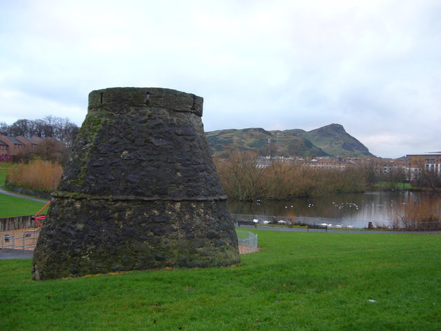
English: Lochend Park -- View over the loch, looking towards Arthur's Seat in the distance. The 16thC bee-hive doocot in the foreground belonged to the Logans of Restalrig who acquired the land in 1382 and lived in Lochend Castle on a nearby crag. In the 1950s, local children were warned that the loch was 'bottomless', having swallowed an entire horse and cart which disappeared without trace - presumably an urban myth aimed at scaring children away from the obvious danger; the loch was unfenced until well into the 1960s. Enjoy the view while it lasts, because new high-rise developments are slowly beginning to encroach upon the surrounding ground. |
| Date | |
| Source | From geograph.org.uk |
| Author | kim traynor |
| Attribution (required by the license) InfoField | kim traynor / Lochend Park / |
InfoField | kim traynor / Lochend Park |
| Camera location | 55° 57′ 45″ N, 3° 09′ 39″ W | View this and other nearby images on: OpenStreetMap |
|---|
| Object location | 55° 57′ 44″ N, 3° 09′ 39″ W | View this and other nearby images on: OpenStreetMap |
|---|
Licensing

|
This image was taken from the Geograph project collection. See this photograph's page on the Geograph website for the photographer's contact details. The copyright on this image is owned by kim traynor and is licensed for reuse under the Creative Commons Attribution-ShareAlike 2.0 license.
|
This file is licensed under the Creative Commons Attribution-Share Alike 2.0 Generic license.
Attribution: kim traynor
- You are free:
- to share – to copy, distribute and transmit the work
- to remix – to adapt the work
- Under the following conditions:
- attribution – You must give appropriate credit, provide a link to the license, and indicate if changes were made. You may do so in any reasonable manner, but not in any way that suggests the licensor endorses you or your use.
- share alike – If you remix, transform, or build upon the material, you must distribute your contributions under the same or compatible license as the original.
Captions
Add a one-line explanation of what this file represents
Items portrayed in this file
depicts
some value
5 December 2009
55°57'44.6"N, 3°9'39.2"W
55°57'43.67"N, 3°9'39.24"W
File history
Click on a date/time to view the file as it appeared at that time.
| Date/Time | Thumbnail | Dimensions | User | Comment | |
|---|---|---|---|---|---|
| current | 06:44, 4 March 2011 | | 640 × 480 (60 KB) | GeographBot | == {{int:filedesc}} == {{Information |description={{en|1=Lochend Park View over the loch, looking towards Arthur's Seat in the distance. The 16thC bee-hive doocot in the foreground belonged to the Logans of Restalrig who acquired the land in 1382 and live |
File usage
The following pages on the English Wikipedia use this file (pages on other projects are not listed):
Metadata
This file contains additional information, probably added from the digital camera or scanner used to create or digitize it.
If the file has been modified from its original state, some details may not fully reflect the modified file.
| _error | 0 |
|---|