File:Location_map_Sacramento.png
From Wikipedia, the free encyclopedia
Size of this preview: 631 × 600 pixels. Other resolutions: 252 × 240 pixels | 505 × 480 pixels | 689 × 655 pixels.
Original file (689 × 655 pixels, file size: 435 KB, MIME type: image/png)
| This is a file from the Wikimedia Commons. Information from its description page there is shown below. Commons is a freely licensed media file repository. You can help. |
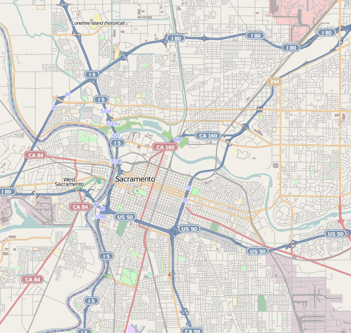
| DescriptionLocation map Sacramento.png |
This map of Sacramento, California was created from OpenStreetMap project data, collected by the community. This map may be incomplete, and may contain errors. Don't rely solely on it for navigation. |
|||||||||
| Date | (see file history) | |||||||||
| Source | openstreetmap.org | |||||||||
| Creator |
OpenStreetMap contributors |
|||||||||
| Permission (Reusing this file) |
OpenStreetMap data and maps are licensed under the Creative Commons Attribution-ShareAlike 2.0 license (CC-BY-SA 2.0). This file is licensed under the Creative Commons Attribution-Share Alike 2.0 Generic license.
|
|||||||||
| Geotemporal data | ||||||||||
| Bounding box |
|
|||||||||
| Georeferencing | Georeference the map in Wikimaps Warper If inappropriate please set warp_status = skip to hide. | |||||||||
Captions
Add a one-line explanation of what this file represents
Items portrayed in this file
depicts
File history
Click on a date/time to view the file as it appeared at that time.
| Date/Time | Thumbnail | Dimensions | User | Comment | |
|---|---|---|---|---|---|
| current | 06:48, 24 September 2010 | | 689 × 655 (435 KB) | Zzyzx11 | {{OpenStreetMap |location=Sacramento, California |top=38.6577 |bottom=38.516 |left=-121.5679 |right=-121.377 }} Category:OpenStreetMap maps of the United States |
File usage
The following pages on the English Wikipedia use this file (pages on other projects are not listed):
- 2022 Sacramento shooting
- American Cash Apartments-American Cash Store
- Anne Hathaway Cottage
- Big Four House
- Blue Anchor Building
- Boulevard Park, Sacramento, California
- Brighton School (Sacramento, California)
- Cal/EPA Building
- California State Capitol
- California State Indian Museum
- Calpak Plant No. 11
- Charles Lais House
- Colonial Heights, Sacramento, California
- Coolot Company Building
- Cranston–Geary House
- Curtis Park, Sacramento, California
- Del Paso Heights, Sacramento, California
- Dunlap's Dining Room
- Eagle Theatre (Sacramento, California)
- East Sacramento, Sacramento, California
- Eastern Star Hall
- Edward P. Howe Jr. House
- Elmhurst, Sacramento, California
- Federal Building (Sacramento)
- Fire Station No. 6 (Sacramento, California)
- Firehouse No. 3 (Sacramento, California)
- George & Mabel Barr House
- Golden 1 Center
- Governor's Mansion State Historic Park
- Heilbron House
- Hotel Lenhart
- Hotel Regis
- J. C. Carly House
- J. Neely Johnson House
- John T. Greene House
- Julia Morgan House
- Julius Wetzlar House
- Lawrence Warehouse
- Leland Stanford Mansion
- Libby, McNeill and Libby Cannery
- Mary Haley Galarneaux House
- Maydestone Apartments
- McKinley Park, Sacramento
- Merchants National Bank of Sacramento
- Merrium Apartments
- Mesick House
- Midtown Sacramento station
- Mohr and Yoerk Market
- Nisei VFW Post 8985
- Oak Park, Sacramento, California
- Old North Sacramento station
- Old Sacramento State Historic Park
- Old Tavern (Sacramento, California)
- PG&E Powerhouse
- Pony Express Terminal
- Ruhstaller Building
- SMUD Headquarters Building
- Sacramento Bank Building
- Sacramento City Library
- Sacramento Hall of Justice
- Sacramento Masonic Temple
- Sacramento Memorial Auditorium
- Senator Hotel
- Shiloh Baptist Church (Sacramento, California)
- Sutter's Fort
- Tahoe Park, Sacramento, California
- The California Museum
- Theodore Judah School
- Thomas Jefferson School (Sacramento, California)
- Westminster Presbyterian Church (Sacramento, California)
- Winters House (Sacramento, California)
- User:Sirrebral/sandbox
- Module:Location map/data/United States Sacramento
- Module:Location map/data/United States Sacramento/doc
Global file usage
The following other wikis use this file:
- Usage on ar.wikipedia.org
- Usage on ceb.wikipedia.org
- Usage on fa.wikipedia.org
- Usage on fr.wikipedia.org
- Usage on kn.wikipedia.org
- Usage on lv.wikipedia.org
- Usage on nl.wikipedia.org
- Usage on pl.wikipedia.org
- Usage on pl.wikibooks.org
- Usage on simple.wikipedia.org
- Usage on si.wikipedia.org
- Usage on tr.wikipedia.org
- Usage on uz.wikipedia.org
- Usage on vep.wikipedia.org
- Usage on war.wikipedia.org
Retrieved from "https://en.wikipedia.org/wiki/File:Location_map_Sacramento.png"