File:Lewis_overthrust_fault_nh10f.jpg
From Wikipedia, the free encyclopedia
Original file (1,400 × 870 pixels, file size: 71 KB, MIME type: image/jpeg)
| This is a file from the Wikimedia Commons. Information from its description page there is shown below. Commons is a freely licensed media file repository. You can help. |
| DescriptionLewis overthrust fault nh10f.jpg |
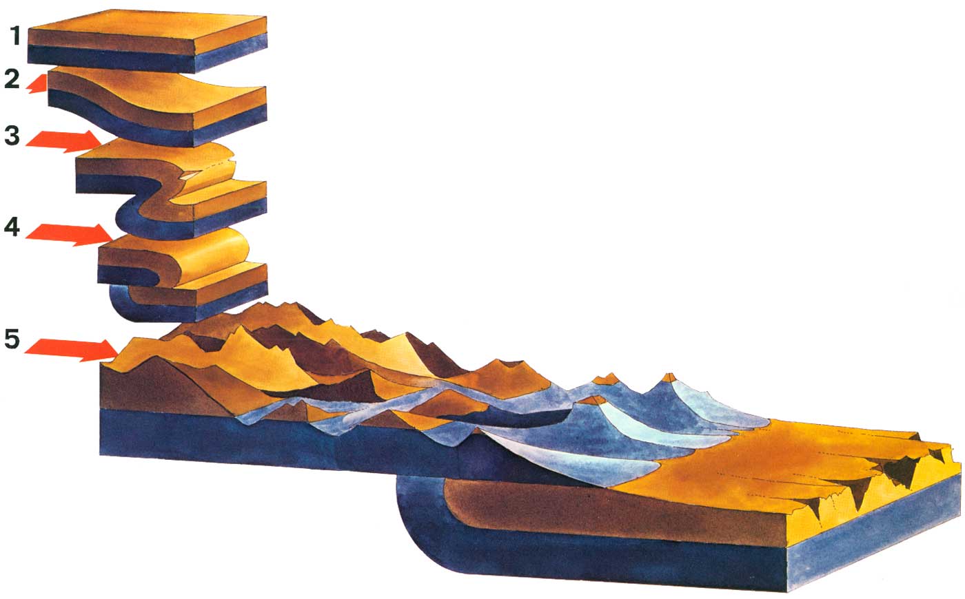
schematic illustration of the Lewis overthrust fault in northern Montana, USA and Southern Alberta, Canada. The fault can be seen best in Glacier National Park, USA and Waterton Lakes National Park, Canada. original caption: Overthrust Mountains 1 A hypothetical block of the Earth's crust in the region of Glacier National Park as it existed more than 60 million years ago. The two layers shown actually represent many strata of sedimentary rocks. 2 Lateral pressure begins to force the rock layers to buckle. 3 A large fold has been created, forcing the rock strata to double over and overturning some layers. A break, or fault, is forming at the plane of greatest stress. 4 The break has been completed and the strata west of the fault have slid eastward, up and over the rocks east of the fault. 5 The Glacier landscape today. Throughout the millions of years during which the folding, faulting, and overthrusting have been taking place, the process of erosion has continued; a thousand meters of stratified rocks have been worn away, so that only a remnant of the overthrust layers can be seen today. Because Glacier's eastern slope represents the eroded face of the overthrust block, the mountain range rises precipitously from the prairie, with no foothills breaking the abrupt transition from open prairie to mountain valley. |
||||
| Date | |||||
| Source | National Park Service http://www.nps.gov/history/history/online_books/natural/10/images/nh10f.jpg - used in the online edition of the book "MANY-STORIED MOUNTAINS - The Life of Glacier National Park" by Greg Beaumont, first published 1978 and online at http://www.nps.gov/history/history/online_books/natural/10/nh10b1.htm | ||||
| Author | Greg Beaumont, National Park Service | ||||
| Permission (Reusing this file) |
|
Captions
Items portrayed in this file
depicts
1978
image/jpeg
File history
Click on a date/time to view the file as it appeared at that time.
| Date/Time | Thumbnail | Dimensions | User | Comment | |
|---|---|---|---|---|---|
| current | 21:58, 9 March 2009 | | 1,400 × 870 (71 KB) | H-stt | {{Information |Description= schematic illustration of the Lewis overthrust fault in northern Montana, USA and Southern Alberta, Canada. The fault can be seen best in Glacier National Park, USA and Waterton Lakes National Park, Canada. original caption: O |
File usage
Global file usage
The following other wikis use this file:
- Usage on bn.wikipedia.org
- Usage on de.wikipedia.org
- Usage on fa.wikipedia.org
- Usage on hi.wikipedia.org
- Usage on ta.wikipedia.org
- Usage on te.wikipedia.org
- Usage on uk.wikipedia.org
- Usage on zh.wikipedia.org
Metadata
This file contains additional information, probably added from the digital camera or scanner used to create or digitize it.
If the file has been modified from its original state, some details may not fully reflect the modified file.
| _error | 0 |
|---|