File:Landlocked_countries.png
From Wikipedia, the free encyclopedia
Size of this preview: 800 × 351 pixels. Other resolutions: 320 × 140 pixels | 640 × 281 pixels | 1,425 × 625 pixels.
Original file (1,425 × 625 pixels, file size: 54 KB, MIME type: image/png)
| This is a file from the Wikimedia Commons. Information from its description page there is shown below. Commons is a freely licensed media file repository. You can help. |

|
File:Landlocked countries.svg is a vector version of this file. It should be used in place of this PNG file when not inferior.
File:Landlocked countries.png → File:Landlocked countries.svg
For more information, see Help:SVG.
|
 |
Contents
Summary
| DescriptionLandlocked countries.png | |
| Date | |
| Source | Own work |
| Author | Ævar Arnfjörð Bjarmason |
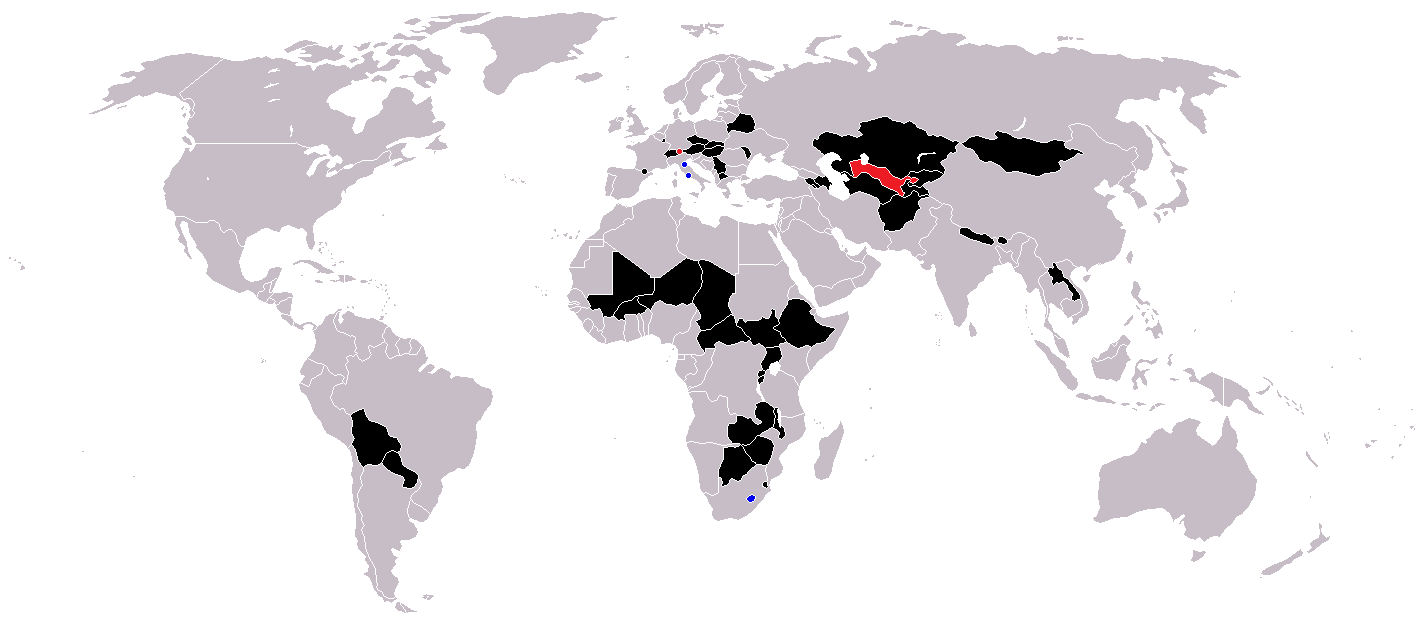
Countries coloured black on the map
Countries coloured red on the map (double landlocked)
Countries coloured blue on the map (landlocked by a single country)
Licensing
| Public domainPublic domainfalsefalse |
| I, the copyright holder of this work, release this work into the public domain. This applies worldwide. In some countries this may not be legally possible; if so: I grant anyone the right to use this work for any purpose, without any conditions, unless such conditions are required by law. |
Captions
Landlocked countries
Pays sans littoral
Estados sin litoral
Stati senza sbocco al mare
Binnenstaaten der Welt
Sisämaavaltiot
Paese ca nun s'affaccene a 'o mare
Binnenstaat
Nações sem saída marítima
Items portrayed in this file
depicts
21 June 2005
image/png
File history
Click on a date/time to view the file as it appeared at that time.
| Date/Time | Thumbnail | Dimensions | User | Comment | |
|---|---|---|---|---|---|
| current | 12:36, 1 June 2018 | | 1,425 × 625 (54 KB) | LamBoet | Reverted to version as of 16:39, 15 July 2011 (UTC) - Restore blue color for countries that are landlocked by a single country |
| 21:34, 2 April 2018 |  | 1,425 × 625 (37 KB) | Maphobbyist | Check | |
| 21:03, 2 April 2018 |  | 1,425 × 625 (37 KB) | Maphobbyist | Black coloring for San Marino, Vatican and Lesotho. | |
| 16:39, 15 July 2011 |  | 1,425 × 625 (54 KB) | Hoshie | added South Sudan and added circles foe European microsates | |
| 13:47, 27 September 2010 |  | 1,425 × 625 (48 KB) | (지금은) 소년시대 | + Landlocked by a single country | |
| 05:33, 23 October 2008 |  | 1,425 × 625 (48 KB) | IngSoc BigBrother | ||
| 16:14, 25 February 2007 |  | 1,425 × 625 (30 KB) | Aivazovsky~commonswiki | ||
| 09:29, 23 May 2006 |  | 1,357 × 628 (46 KB) | Stefan040780 | source: same as old map, updated on 23.5.06 by stefan040780 | |
| 03:08, 21 June 2005 |  | 1,357 × 628 (25 KB) | Ævar Arnfjörð Bjarmason | Landlocked countries, based on Image:BlankMap-World.png. Category:World maps |
File usage
No pages on the English Wikipedia use this file (pages on other projects are not listed).
Global file usage
The following other wikis use this file:
- Usage on ckb.wikipedia.org
- Usage on da.wikipedia.org
- Usage on eu.wikipedia.org
- Usage on fa.wikipedia.org
- Usage on fo.wikipedia.org
- Usage on fr.wikipedia.org
- Usage on hr.wikipedia.org
- Usage on hu.wikipedia.org
- Usage on is.wiktionary.org
- Usage on ja.wikipedia.org
- Usage on ja.wiktionary.org
- Usage on kk.wikipedia.org
- Usage on ko.wikipedia.org
- Usage on mk.wikipedia.org
- Usage on ms.wikipedia.org
- Usage on nso.wikipedia.org
- Usage on te.wikipedia.org
- Usage on uk.wikipedia.org
- Usage on vi.wikipedia.org
- Usage on zh-yue.wikipedia.org
Metadata
This file contains additional information, probably added from the digital camera or scanner used to create or digitize it.
If the file has been modified from its original state, some details may not fully reflect the modified file.
| Horizontal resolution | 37.8 dpc |
|---|---|
| Vertical resolution | 37.8 dpc |
Retrieved from "https://en.wikipedia.org/wiki/File:Landlocked_countries.png"