File:Lake_Superior_bathymetry_map_2.png
From Wikipedia, the free encyclopedia
Original file (1,024 × 636 pixels, file size: 699 KB, MIME type: image/png)
| This is a file from the Wikimedia Commons. Information from its description page there is shown below. Commons is a freely licensed media file repository. You can help. |
Summary
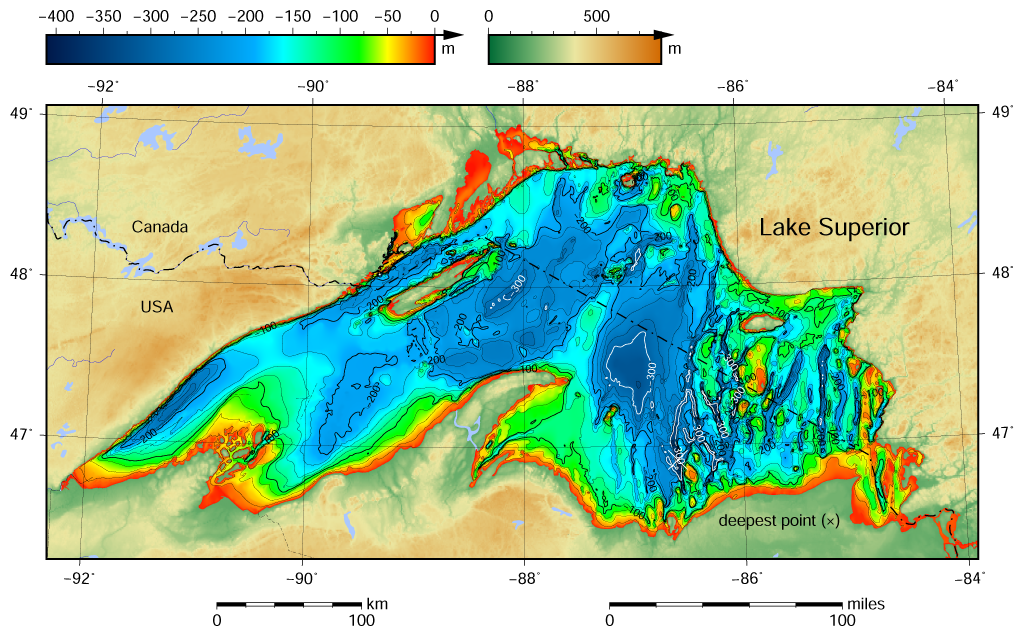
| DescriptionLake Superior bathymetry map 2.png |
English: Lake Superior bathymetric relief map contoured with interval 25 m (100 m with thicker lines). The deepest point is marked with "×". For land the vertical datum is sea level, for bathymetry low water datum of the lake. According to NGDC information, Lake Superior data this map is based on are incomplete. |
| Date | |
| Source |
Own work using: the following Public Domain datasets (grids):
The coordinates of deepest point are taken from the NOAA Great Lakes Environmental Research Laboratory webpage (www.glerl.noaa.gov/, kml file Google Earth Great Lakes Tour). |
| Author | Darekk2 using the Great Lakes Bathymetry and GLOBE tiles |
| Other versions |
|

Licensing
Attribution (in addition to the author of this map):
The NGDC in it's copyright notice says:
As required by 17 U.S.C. 403, third parties producing copyrighted works consisting predominantly of the material produced by U.S. government agencies must provide notice with such work(s) identifying the U.S. Government material incorporated and stating that such material is not subject to copyright protection within the United States. (...)
(for credits see the Source section).
and Great Lakes Bathymetry and GLOBE
(see above and the Source section)
- You are free:
- to share – to copy, distribute and transmit the work
- to remix – to adapt the work
- Under the following conditions:
- attribution – You must give appropriate credit, provide a link to the license, and indicate if changes were made. You may do so in any reasonable manner, but not in any way that suggests the licensor endorses you or your use.
- share alike – If you remix, transform, or build upon the material, you must distribute your contributions under the same or compatible license as the original.
Captions
Items portrayed in this file
depicts
1 April 2015
File history
Click on a date/time to view the file as it appeared at that time.
| Date/Time | Thumbnail | Dimensions | User | Comment | |
|---|---|---|---|---|---|
| current | 18:10, 9 May 2015 | | 1,024 × 636 (699 KB) | Darekk2 | more Huron |
| 16:00, 11 April 2015 |  | 1,024 × 636 (699 KB) | Darekk2 | added some annotations to contours, made contours with interval 100 m bold, made contours 300 m white, added rivers and minor lakes | |
| 15:50, 1 April 2015 |  | 1,024 × 636 (683 KB) | Darekk2 | User created page with UploadWizard |
File usage
Global file usage
The following other wikis use this file: