File:Kocaeli_districts.png
From Wikipedia, the free encyclopedia
No higher resolution available.
Kocaeli_districts.png (776 × 600 pixels, file size: 128 KB, MIME type: image/png)
| This is a file from the Wikimedia Commons. Information from its description page there is shown below. Commons is a freely licensed media file repository. You can help. |
Summary
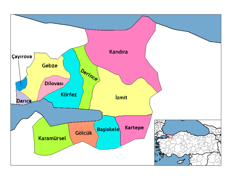
| DescriptionKocaeli districts.png | Map of the districts of Kocaeli province in Turkey. Created by Rarelibra 22:01, 1 December 2006 (UTC) for public domain use, using MapInfo Professional v8.5 and various mapping resources. Edited by One Homo Sapiens Corrected text where İ,Ş,ı,ğ,or ş occurs in name. Source: [statoids-com]. Increased font size and enhanced color differences among adjacent districts. |
| Date | 1 December 2006 (original upload date) |
| Source | No machine-readable source provided. Own work assumed (based on copyright claims). |
| Author | No machine-readable author provided. Rarelibra assumed (based on copyright claims). |
Licensing
| Public domainPublic domainfalsefalse |
| I, the copyright holder of this work, release this work into the public domain. This applies worldwide. In some countries this may not be legally possible; if so: I grant anyone the right to use this work for any purpose, without any conditions, unless such conditions are required by law. |
Captions
Add a one-line explanation of what this file represents
Items portrayed in this file
depicts
1 December 2006
File history
Click on a date/time to view the file as it appeared at that time.
| Date/Time | Thumbnail | Dimensions | User | Comment | |
|---|---|---|---|---|---|
| current | 11:58, 11 December 2018 | | 776 × 600 (128 KB) | Surprizi | Updated/corrected map. |
| 20:25, 28 February 2012 |  | 469 × 403 (38 KB) | Sadrettin | Reverted to version as of 09:02, 31 August 2009 | |
| 09:54, 26 February 2012 |  | 776 × 600 (121 KB) | Nanahuatl | Reverted to version as of 13:17, 17 June 2009 | |
| 09:02, 31 August 2009 |  | 469 × 403 (38 KB) | Krofesyonel | {{Information |Description=Kocaeli'nin doğru haritası, kendi çalışmamdır. |Source=Kendi çalışmam |Date=31 August 2009, Monday (''31 Ağustos 2009, Pazartesi'') |Author=User:Krofesyonel |Permission= |other_versions= }} | |
| 13:17, 17 June 2009 |  | 776 × 600 (121 KB) | Argymeg | Reverted to version as of 19:23, 7 April 2009 | |
| 19:24, 7 April 2009 |  | 1,056 × 816 (26 KB) | Derinkaya | Reverted to version as of 01:23, 29 December 2008 | |
| 19:23, 7 April 2009 |  | 776 × 600 (121 KB) | Derinkaya | {{Information |Description=Map of the districts of Kocaeli province in Turkey. Created by Rarelibra 22:01, 1 December 2006 (UTC) for public domain use, using MapInfo Professional v8.5 and various mapping resources. Edited by [[User:One | |
| 01:23, 29 December 2008 |  | 1,056 × 816 (26 KB) | One Homo Sapiens | Corrected text where İ,Ş,ı,ğ,or ş occurs in name. Source: [statoids-com]. Increased font size and enhanced color differences among adjacent districts. | |
| 15:58, 12 April 2007 |  | 776 × 600 (96 KB) | KureCewlik81 | ||
| 14:15, 20 February 2007 |  | 1,056 × 816 (27 KB) | Rarelibra | Updated/corrected map. |
File usage
The following pages on the English Wikipedia use this file (pages on other projects are not listed):
Global file usage
The following other wikis use this file:
- Usage on azb.wikipedia.org
- Usage on az.wikipedia.org
- Usage on ba.wikipedia.org
- Usage on diq.wikipedia.org
- Usage on en.wiktionary.org
- Usage on eo.wikipedia.org
- Usage on eu.wikipedia.org
- Usage on fa.wikipedia.org
- Usage on fi.wikipedia.org
- Usage on fo.wikipedia.org
- Usage on fr.wikipedia.org
- Usage on hy.wikipedia.org
- Usage on id.wikipedia.org
- Usage on it.wikipedia.org
- Usage on ja.wikipedia.org
- Usage on jv.wikipedia.org
- Usage on ka.wikipedia.org
- Usage on la.wikipedia.org
- Usage on lv.wikipedia.org
- Usage on mr.wikipedia.org
- Usage on ms.wikipedia.org
View more global usage of this file.
Metadata
This file contains additional information, probably added from the digital camera or scanner used to create or digitize it.
If the file has been modified from its original state, some details may not fully reflect the modified file.
| Horizontal resolution | 37.78 dpc |
|---|---|
| Vertical resolution | 37.78 dpc |
Retrieved from "https://en.wikipedia.org/wiki/File:Kocaeli_districts.png"