File:Karte_Mittelrhein.png
From Wikipedia, the free encyclopedia
Size of this preview: 508 × 600 pixels. Other resolutions: 203 × 240 pixels | 406 × 480 pixels | 650 × 768 pixels | 1,270 × 1,500 pixels.
Original file (1,270 × 1,500 pixels, file size: 2.95 MB, MIME type: image/png)
| This is a file from the Wikimedia Commons. Information from its description page there is shown below. Commons is a freely licensed media file repository. You can help. |
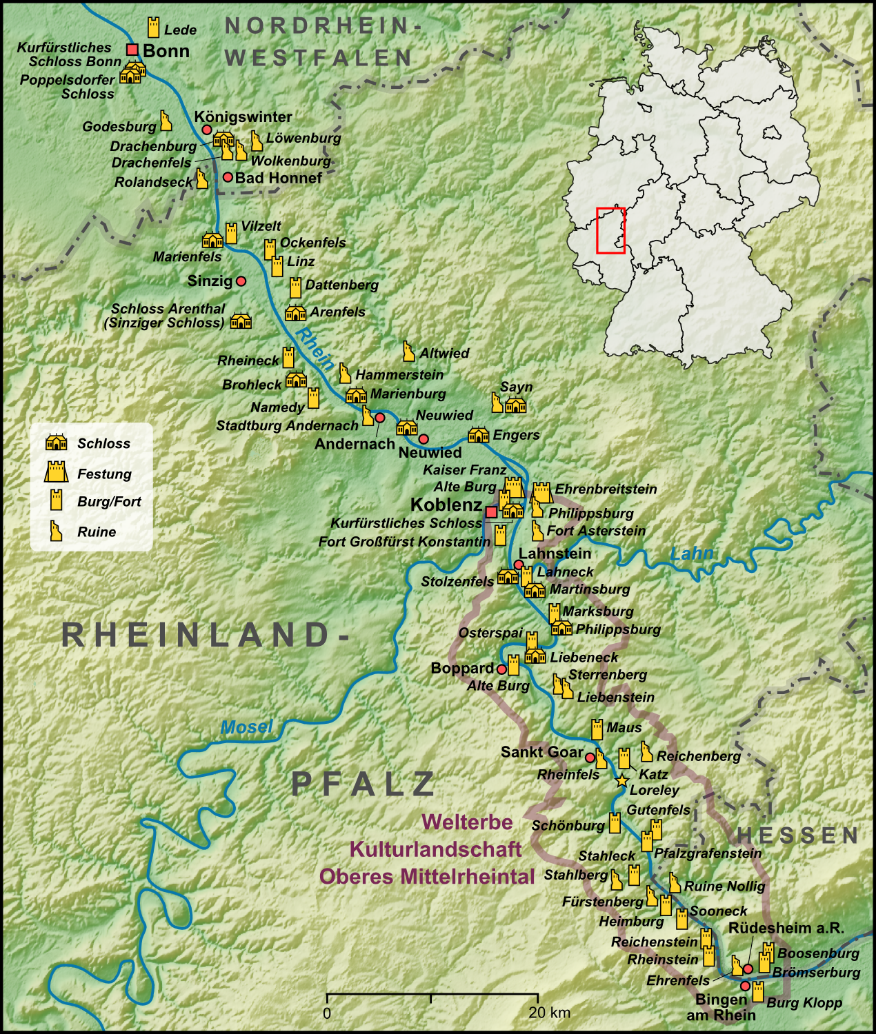
| DescriptionKarte Mittelrhein.png | |
| Date | |
| Source |
Own work, used:
|
| Author | Lencer |

|
This map has been made or improved in the German Kartenwerkstatt (Map Lab). You can propose maps to improve as well.
azərbaycanca ∙ čeština ∙ Deutsch ∙ Deutsch (Sie-Form) ∙ English ∙ español ∙ français ∙ italiano ∙ latviešu ∙ magyar ∙ Nederlands ∙ Plattdüütsch ∙ polski ∙ português ∙ română ∙ sicilianu ∙ slovenščina ∙ suomi ∙ македонски ∙ русский ∙ ქართული ∙ հայերեն ∙ বাংলা ∙ ไทย ∙ +/−
|
The map has been created with the Generic Mapping Tools: https://www.generic-mapping-tools.org/ using one or more of these public-domain datasets for the relief:
বাংলা ∙ English ∙ español ∙ français ∙ italiano ∙ 日本語 ∙ македонски ∙ sicilianu ∙ 中文(简体) ∙ 中文(繁體) ∙ +/− |

|
Permission is granted to copy, distribute and/or modify this document under the terms of the GNU Free Documentation License, Version 1.2 or any later version published by the Free Software Foundation; with no Invariant Sections, no Front-Cover Texts, and no Back-Cover Texts. A copy of the license is included in the section entitled GNU Free Documentation License.http://www.gnu.org/copyleft/fdl.htmlGFDLGNU Free Documentation Licensetruetrue |
Captions
Add a one-line explanation of what this file represents
Items portrayed in this file
depicts
December 2009
image/png
File history
Click on a date/time to view the file as it appeared at that time.
| Date/Time | Thumbnail | Dimensions | User | Comment | |
|---|---|---|---|---|---|
| current | 17:37, 5 August 2014 | | 1,270 × 1,500 (2.95 MB) | Schaengel | Reverted to version as of 23:24, 17 March 2014 |
| 23:19, 4 August 2014 |  | 1,260 × 1,490 (2.86 MB) | Ras67 | cropped | |
| 23:24, 17 March 2014 |  | 1,270 × 1,500 (2.95 MB) | Kopiersperre | optipng | |
| 08:36, 3 December 2009 |  | 1,270 × 1,500 (3.36 MB) | Lencer | einige Ergänzungen | |
| 13:10, 30 November 2009 |  | 1,270 × 1,500 (3.36 MB) | Lencer | {{Information| |Description= {{de|Karte der Region Mittelrhein und der Welterbestätte Kulturlandschaft Oberes Mittelrheintal }} |Source={{Own}}, used: * [[:de:Generic Mapping Too |
File usage
The following pages on the English Wikipedia use this file (pages on other projects are not listed):
- Boosenburg
- Drachenfels (Siebengebirge)
- Ehrenfels Castle (Hesse)
- Fürstenberg Castle (Rheindiebach)
- Godesburg
- Gutenfels Castle
- Katz Castle
- Klopp Castle
- Lahneck Castle
- Liebenstein Castle (Rhine)
- Marksburg
- Maus Castle
- Middle Rhine
- Mouse Tower
- Nollig Castle
- Pfalzgrafenstein Castle
- Poppelsdorf Palace
- Reichenstein Castle (Trechtingshausen)
- Rheinfels Castle
- Rheinstein Castle
- Rhine Gorge
- Schloss Drachenburg
- Schönburg (Rhine)
- Sooneck Castle
- Stahleck Castle
- Sterrenberg Castle (Rhineland)
- Template:Castles in Germany - The Middle Rhine Valley
Global file usage
The following other wikis use this file:
- Usage on ca.wikipedia.org
- Usage on cs.wikipedia.org
- Usage on da.wikipedia.org
- Usage on de.wikipedia.org
- Koblenz
- Mittelrhein
- Festung Ehrenbreitstein
- Burg Stahleck (Bacharach)
- Burg Vilzelt
- Marksburg
- Burg Ehrenfels (Hessen)
- Schönburg (Rhein)
- Godesburg
- Binger Mäuseturm
- Burg Maus
- Burg Altwied
- Poppelsdorfer Schloss
- Burg Rheinfels
- Schloss Marienfels
- Burg Katz
- Schloss Drachenburg
- Burg Pfalzgrafenstein
- Kurfürstliches Schloss (Bonn)
- Schloss Stolzenfels
- Burg Lahneck
- Burg Sooneck
- Sauerburg
- Burg Rheinstein
- Burg Klopp
- Ruine Nollig
- Burg Reichenstein (Mittelrhein)
- Schloss Engers
- Burg Liebenstein (Rheintal)
- Alte Burg (Koblenz)
- Burg Sterrenberg (Rheinland)
- Kurfürstliches Schloss (Koblenz)
- Burg Rolandseck
- Schloss Brohleck
- Burg Rheineck
- Burg Wolkenburg
- Heimburg (Niederheimbach)
- Burg Fürstenberg (Rheindiebach)
- Burg Gutenfels
- Oberes Mittelrheintal
- Brömserburg
- Schloss Sayn
- Boosenburg
- Schloss Philippsburg (Koblenz)
- Burg Sayn
- Burg Reichenberg (Rheinland-Pfalz)
- Kurfürstliche Burg (Boppard)
View more global usage of this file.
Metadata
This file contains additional information, probably added from the digital camera or scanner used to create or digitize it.
If the file has been modified from its original state, some details may not fully reflect the modified file.
| Horizontal resolution | 79.81 dpc |
|---|---|
| Vertical resolution | 79.81 dpc |
| Software used |
Retrieved from "https://en.wikipedia.org/wiki/File:Karte_Mittelrhein.png"