File:Israel_judea_and_samaria_dist.png
From Wikipedia, the free encyclopedia
Size of this preview: 216 × 599 pixels. Other resolution: 267 × 740 pixels.
Original file (267 × 740 pixels, file size: 29 KB, MIME type: image/png)
| This is a file from the Wikimedia Commons. Information from its description page there is shown below. Commons is a freely licensed media file repository. You can help. |
Summary

|
This locator map image could be re-created using vector graphics as an SVG file. This has several advantages; see Commons:Media for cleanup for more information. If an SVG form of this image is available, please upload it and afterwards replace this template with
{{vector version available|new image name}}.
It is recommended to name the SVG file “Israel judea and samaria dist.svg”—then the template Vector version available (or Vva) does not need the new image name parameter. |
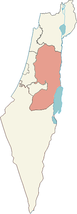
| DescriptionIsrael judea and samaria dist.png |
עברית: המחשה ויזואלית של he:מחוז יהודה ושומרון English: Israel: Judea and Samaria District according to official Israeli regulations. Unlike other administrative districts of Israel, this district is not entirely territorial - it includes only the Israeli settlements in the West Bank (excluding East Jerusalem which was annexed to Israeli Jerusalem district). |
| Date |
6 November 2006 (original upload date) |
| Source | אני יצרתי תמונה זו בהסתמך על תמונה של מחוז אחר בישראל, התמונה המקורית מקורה בויקישיתוף תחת רישיון חופשי. |
| Author | Ramiy at Hebrew Wikipedia |
Licensing
Ramiy at the English-language Wikipedia, the copyright holder of this work, hereby publishes it under the following license:

|
Permission is granted to copy, distribute and/or modify this document under the terms of the GNU Free Documentation License, Version 1.2 or any later version published by the Free Software Foundation; with no Invariant Sections, no Front-Cover Texts, and no Back-Cover Texts. A copy of the license is included in the section entitled GNU Free Documentation License.http://www.gnu.org/copyleft/fdl.htmlGFDLGNU Free Documentation Licensetruetrue |
| This file is licensed under the Creative Commons Attribution-Share Alike 3.0 Unported license. | ||
| Attribution: Ramiy | ||
| ||
| This licensing tag was added to this file as part of the GFDL licensing update.http://creativecommons.org/licenses/by-sa/3.0/CC BY-SA 3.0Creative Commons Attribution-Share Alike 3.0truetrue |
Original upload log
The original description page was here. All following user names refer to he.wikipedia.
- 2006-11-06 20:03 Ramiy 267×740×8 (29274 bytes) ==רשיון==
Captions
Add a one-line explanation of what this file represents
Items portrayed in this file
depicts
6 November 2006
File history
Click on a date/time to view the file as it appeared at that time.
| Date/Time | Thumbnail | Dimensions | User | Comment | |
|---|---|---|---|---|---|
| current | 14:47, 29 May 2008 | 267 × 740 (29 KB) | Hanhil | {{Information |Description={{he|המחשה ויזואלית של he:מחוז יהודה ושומרון}}{{en|Israel: Judea and Samaria District}} |Source=Transferred from [http://he.wikipedia.org he.wikipedia]<br/> (Original text : ''אני יצרת� |
File usage
The following pages on the English Wikipedia use this file (pages on other projects are not listed):
- Ahiya
- Alfei Menashe
- Alon Shvut
- Area C (West Bank)
- Ariel (Israeli settlement)
- Beit Aryeh-Ofarim
- Beit El
- Beit HaShalom
- Beitar Illit
- Bik'at HaYarden Regional Council
- Efrat (Israeli settlement)
- Elkana
- Giv'at Ze'ev
- Givat Harsina
- Gush Etzion
- Gush Etzion Junction
- Gush Etzion Regional Council
- Har Adar
- Har Hevron Regional Council
- Immanuel (Israeli settlement)
- Israeli Civil Administration
- Judaean Desert
- Judea
- Judea and Samaria Area
- Karnei Shomron
- Kedumim
- Kiryat Arba
- List of Israeli settlements
- Ma'ale Adumim
- Ma'ale Efrayim
- Mateh Binyamin Regional Council
- Megilot Regional Council
- Modi'in Illit
- Oranit
- Oz Zion
- Population statistics for Israeli settlements in the West Bank
- Samaria
- Shomron Regional Council
- Yesha
- Yesha Council
- Talk:Samaria
- Wikipedia talk:WikiProject Israel Palestine Collaboration/Current Article Issues/Archive 8
- Template:Judea and Samaria Area
Global file usage
The following other wikis use this file:
- Usage on af.wikipedia.org
- Usage on an.wikipedia.org
- Usage on ar.wikipedia.org
- معاليه أدوميم
- أرئيل (مستوطنة)
- بيتار عيليت
- موديعين عيليت
- كريات أربع
- مجلس جنوب جبل الخليل الإقليمي
- أفرات
- يهودا والسامرة
- بيت إيل
- جفعات زئيف
- عمانوئيل (مستوطنة)
- الإدارة المدنية الإسرائيلية
- استيطان إسرائيلي
- قالب:منطقة يهودا والسامرة
- قرنيه شمرون
- مجلس شمرون الإقليمي
- مجلس ماتي بنيامين الإقليمي
- منطقة ج (الضفة الغربية)
- مجلس البحر الميت الإقليمي
- معاليه إفرايم
- كدوميم
- بيت أرييه
- الإحصائيات السكانية للمستوطنات الإسرائيلية في الضفة الغربية
- Usage on arz.wikipedia.org
- Usage on azb.wikipedia.org
- Usage on az.wikipedia.org
- Usage on ca.wikipedia.org
- Usage on ce.wikipedia.org
- Usage on cs.wikipedia.org
View more global usage of this file.
Retrieved from "https://en.wikipedia.org/wiki/File:Israel_judea_and_samaria_dist.png"