File:ICE_Network.png
From Wikipedia, the free encyclopedia
Size of this preview: 444 × 599 pixels. Other resolutions: 178 × 240 pixels | 355 × 480 pixels | 569 × 768 pixels | 1,200 × 1,620 pixels.
Original file (1,200 × 1,620 pixels, file size: 582 KB, MIME type: image/png)
| This is a file from the Wikimedia Commons. Information from its description page there is shown below. Commons is a freely licensed media file repository. You can help. |

|
This transport map image could be re-created using vector graphics as an SVG file. This has several advantages; see Commons:Media for cleanup for more information. If an SVG form of this image is available, please upload it and afterwards replace this template with
{{vector version available|new image name}}.
It is recommended to name the SVG file “ICE Network.svg”—then the template Vector version available (or Vva) does not need the new image name parameter. |
Contents
Summary
Deutsch (de): Deutsches ICE-Netz
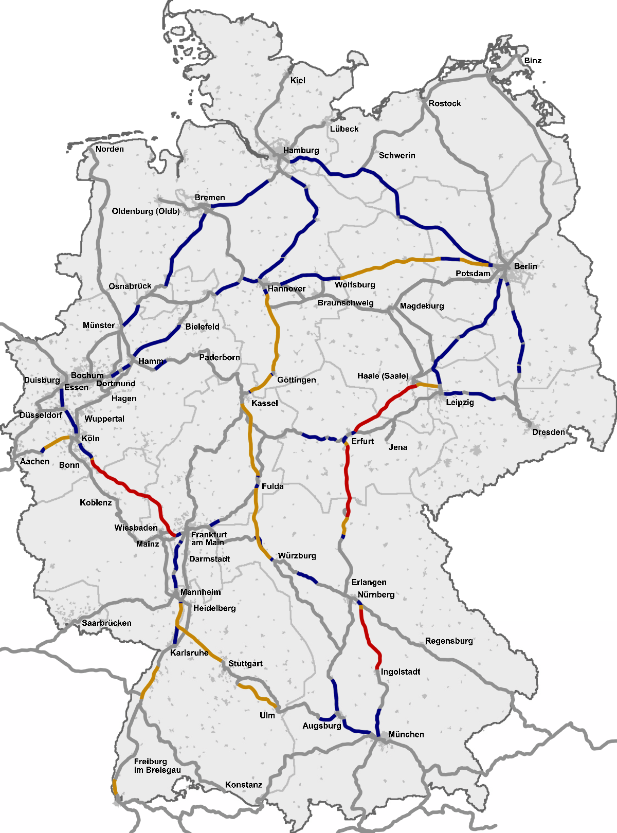
English (en): The InterCityExpress (ICE) network in Germany
Esperanto (eo): Reto de ICE en Germanio
español (es): Red InterCityExpress (ICE) en Alemania
italiano (it): La rete degli InterCityExpress (ICE) in Germania
français (fr): Réseau ICE allemand
Nederlands (nl): Duitse ICE-net
slovenčina (sk): Sieť ICE vlakov v Nemeckej spolkovej republike
polski (pl): Sieć pociągów ICE w Niemczech
čeština (cs): Síť vysokorychlostních vlaků ICE v Německu
română (ro): Reteaua InterCityExpress (ICE) in Germania
한국어 (ko): 독일 ICE 선로망 최고속도 표
suomi (fi): InterCityExpress (ICE) -verkko Saksassa
русский (ru): Сеть железнодорожных путей InterCityExpress (ICE) в Германии
中文 (zh): 城际特快列车 InterCityExpress (ICE) 在德国的铁路网
українська (uk): Мережа залізничних колій InterCityExpress (ICE) у Німеччині
Ελληνικά (el): Το σιδηροδρομικό δίκτυο της υπερταχείας InterCityExpress (ICE) στην Γερμανία
Source
Based on a map from OpenGeoDB, data from DB timetables, OpenRailwayMap and a map from ice-fanpage.de and DB releases like this.
See also
See also 
|
Licensing
This image was generated with OpenGeoDB. The information there is placed in the public domain, images generated from OpenGeoDB are derivative works without passing the threshold of creativity, they are therefore also public domain.
| Public domainPublic domainfalsefalse |
| This work is ineligible for copyright and therefore in the public domain because it consists entirely of information that is common property and contains no original authorship. |
Captions
The InterCityExpress (ICE) network map in Germany
ICE-Streckennetz mit Geschwindigkeitsangaben (Stand 2023)
Réseau InterCityExpress (ICE) allemand
Red InterCityExpress (ICE) en Alemania
image/png
File history
Click on a date/time to view the file as it appeared at that time.
| Date/Time | Thumbnail | Dimensions | User | Comment | |
|---|---|---|---|---|---|
| current | 09:18, 29 December 2022 | | 1,200 × 1,620 (582 KB) | DerBaomeister | Addition of line between Osnabrück and Löhne |
| 08:48, 29 December 2022 |  | 1,200 × 1,620 (582 KB) | DerBaomeister | Addition of line between Berlin and Rostock | |
| 02:15, 29 December 2022 |  | 1,200 × 1,620 (579 KB) | DerBaomeister | Addition of two lines and Potsdam | |
| 00:59, 29 December 2022 |  | 1,200 × 1,620 (578 KB) | DerBaomeister | Second general revision of map with addition of new high-speed line between Wendlingen and Ulm | |
| 02:37, 1 November 2022 |  | 1,200 × 1,620 (589 KB) | DerBaomeister | Small addition of stop in Coburg | |
| 12:40, 27 October 2022 |  | 1,200 × 1,620 (589 KB) | DerBaomeister | Minor corrections | |
| 20:19, 18 October 2022 |  | 1,200 × 1,620 (589 KB) | DerBaomeister | Improvements around Stuttgart; removal of one line | |
| 00:17, 10 October 2022 |  | 1,200 × 1,620 (590 KB) | DerBaomeister | Some improvements | |
| 16:16, 27 August 2022 |  | 1,200 × 1,620 (592 KB) | DerBaomeister | Further extension of international ICE/ECE lines | |
| 17:34, 13 August 2022 |  | 1,200 × 1,620 (582 KB) | DerBaomeister | Extension of international ICE lines |
File usage
The following pages on the English Wikipedia use this file (pages on other projects are not listed):
Global file usage
The following other wikis use this file:
- Usage on bar.wikipedia.org
- Usage on ca.wikipedia.org
- Usage on cs.wikipedia.org
- Usage on da.wikipedia.org
- Usage on de.wikipedia.org
- Usage on el.wikipedia.org
- Usage on es.wikipedia.org
- Usage on fi.wikipedia.org
- Usage on fr.wikipedia.org
- Usage on fy.wikipedia.org
- Usage on hu.wikipedia.org
- Usage on it.wikipedia.org
- Usage on ja.wikipedia.org
- Usage on ko.wikipedia.org
- Usage on lad.wikipedia.org
- Usage on lb.wikipedia.org
- Usage on ms.wikipedia.org
- Usage on nl.wikipedia.org
- Usage on nn.wikipedia.org
- Usage on no.wikipedia.org
- Usage on pl.wikipedia.org
- Usage on ro.wikipedia.org
- Usage on ru.wikipedia.org
- Usage on sh.wikipedia.org
- Usage on simple.wikipedia.org
- Usage on sk.wikipedia.org
- Usage on sr.wikipedia.org
- Usage on uk.wikipedia.org
- Usage on zh.wikipedia.org
Retrieved from "https://en.wikipedia.org/wiki/File:ICE_Network.png"