File:Hungary_1941-44_Administrative_Map.png
From Wikipedia, the free encyclopedia
Size of this preview: 800 × 431 pixels. Other resolutions: 320 × 173 pixels | 640 × 345 pixels | 1,024 × 552 pixels | 1,280 × 690 pixels | 2,560 × 1,380 pixels | 4,000 × 2,157 pixels.
Original file (4,000 × 2,157 pixels, file size: 2.55 MB, MIME type: image/png)
| This is a file from the Wikimedia Commons. Information from its description page there is shown below. Commons is a freely licensed media file repository. You can help. |

|
This map image could be re-created using vector graphics as an SVG file. This has several advantages; see Commons:Media for cleanup for more information. If an SVG form of this image is available, please upload it and afterwards replace this template with
{{vector version available|new image name}}.
It is recommended to name the SVG file “Hungary 1941-44 Administrative Map.svg”—then the template Vector version available (or Vva) does not need the new image name parameter. |
Summary
| DescriptionHungary 1941-44 Administrative Map.png |
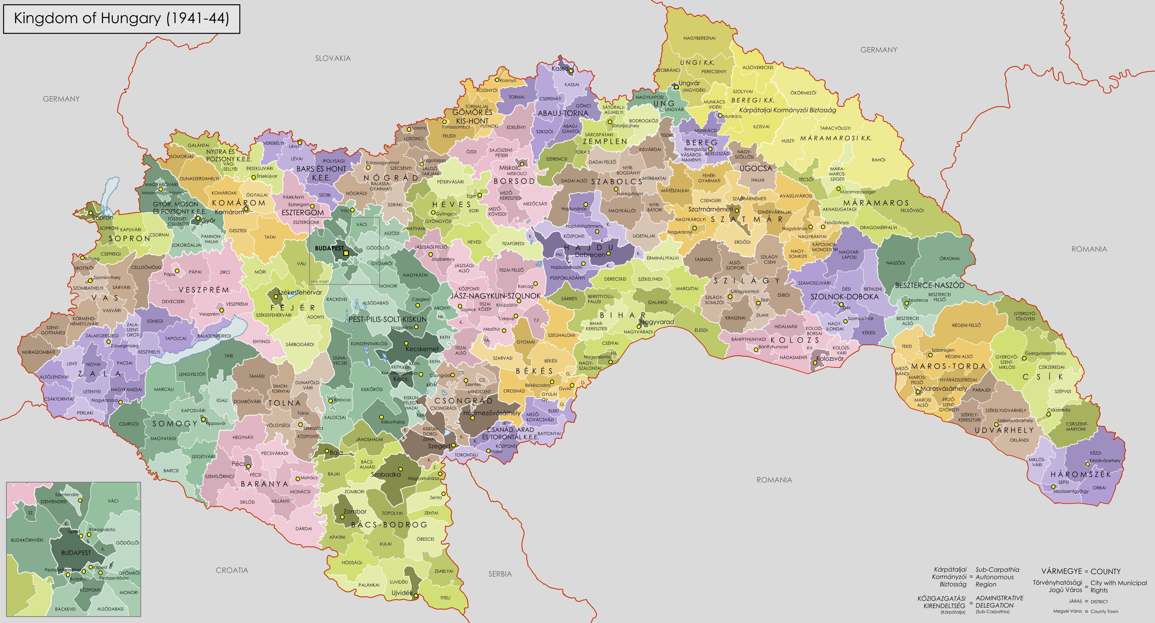
English: Administrative Map of the Kingdom of Hungary from 1941-44. |
| Date | |
| Source |
Own work using:
|
| Author | XrysD |
Licensing
I, the copyright holder of this work, hereby publish it under the following licenses:

|
Permission is granted to copy, distribute and/or modify this document under the terms of the GNU Free Documentation License, Version 1.2 or any later version published by the Free Software Foundation; with no Invariant Sections, no Front-Cover Texts, and no Back-Cover Texts. A copy of the license is included in the section entitled GNU Free Documentation License.http://www.gnu.org/copyleft/fdl.htmlGFDLGNU Free Documentation Licensetruetrue |
| This file is licensed under the Creative Commons Attribution-Share Alike 3.0 Unported license. | ||
| ||
| This licensing tag was added to this file as part of the GFDL licensing update.http://creativecommons.org/licenses/by-sa/3.0/CC BY-SA 3.0Creative Commons Attribution-Share Alike 3.0truetrue |
You may select the license of your choice.
Captions
Add a one-line explanation of what this file represents
Items portrayed in this file
depicts
18 January 2009
File history
Click on a date/time to view the file as it appeared at that time.
| Date/Time | Thumbnail | Dimensions | User | Comment | |
|---|---|---|---|---|---|
| current | 18:04, 25 August 2016 | | 4,000 × 2,157 (2.55 MB) | XrysD | Fixed typo for Hajduböszörmeny (thanks Tunde). |
| 12:40, 11 April 2009 |  | 4,000 × 2,157 (2.58 MB) | XrysD | Borders edited to be more accurate and spelling mistakes corrected | |
| 21:15, 18 January 2009 |  | 4,000 × 2,215 (2.47 MB) | XrysD | {{Information |Description= |Source= |Date= |Author= |Permission= |other_versions= }} | |
| 20:50, 18 January 2009 |  | 4,940 × 2,736 (3.18 MB) | XrysD | {{Information |Description={{en|1=Administrative Map of the Kingdom of Hungary from 1941-44.}} |Source=Own work by uploader |Author=XrysD |Date=18/01/2009 |Permission= |other_versions= }} <!--{{ImageUpload|full}}--> |
File usage
The following pages on the English Wikipedia use this file (pages on other projects are not listed):
Global file usage
The following other wikis use this file:
- Usage on azb.wikipedia.org
- Usage on bn.wikipedia.org
- Usage on cy.wikipedia.org
- Usage on de.wikipedia.org
- Usage on eu.wikipedia.org
- Usage on fr.wikipedia.org
- Usage on hu.wikipedia.org
- Usage on hy.wikipedia.org
- Usage on id.wikipedia.org
- Usage on it.wikipedia.org
- Usage on ja.wikipedia.org
- Usage on mk.wikipedia.org
- Usage on nl.wikipedia.org
- Usage on pl.wikipedia.org
- Usage on pt.wikipedia.org
- Usage on ro.wikipedia.org
- Usage on ru.wikipedia.org
- Usage on sh.wikipedia.org
- Usage on sl.wikipedia.org
- Usage on sr.wikipedia.org
- Usage on te.wikipedia.org
- Usage on th.wikipedia.org
- Usage on uk.wikipedia.org
- Usage on zh.wikipedia.org
Metadata
This file contains additional information, probably added from the digital camera or scanner used to create or digitize it.
If the file has been modified from its original state, some details may not fully reflect the modified file.
| Horizontal resolution | 30.23 dpc |
|---|---|
| Vertical resolution | 30.23 dpc |