File:Historic_Triangle_Virginia.jpg
From Wikipedia, the free encyclopedia
Size of this preview: 800 × 532 pixels. Other resolutions: 320 × 213 pixels | 640 × 426 pixels | 1,024 × 681 pixels | 1,280 × 851 pixels | 2,923 × 1,944 pixels.
Original file (2,923 × 1,944 pixels, file size: 526 KB, MIME type: image/jpeg)
| This is a file from the Wikimedia Commons. Information from its description page there is shown below. Commons is a freely licensed media file repository. You can help. |
Summary

|
This road map image could be re-created using vector graphics as an SVG file. This has several advantages; see Commons:Media for cleanup for more information. If an SVG form of this image is available, please upload it and afterwards replace this template with
{{vector version available|new image name}}.
It is recommended to name the SVG file “Historic Triangle Virginia.svg”—then the template Vector version available (or Vva) does not need the new image name parameter. |
 | This road map image was uploaded in the JPEG format even though it consists of non-photographic data. This information could be stored more efficiently or accurately in the PNG or SVG format. If possible, please upload a PNG or SVG version of this image without compression artifacts, derived from a non-JPEG source (or with existing artifacts removed). After doing so, please tag the JPEG version with {{Superseded|NewImage.ext}} and remove this tag. This tag should not be applied to photographs or scans. If this image is a diagram or other image suitable for vectorisation, please tag this image with {{Convert to SVG}} instead of {{BadJPEG}}. If not suitable for vectorisation, use {{Convert to PNG}}. For more information, see {{BadJPEG}}. |  |
| DescriptionHistoric Triangle Virginia.jpg |
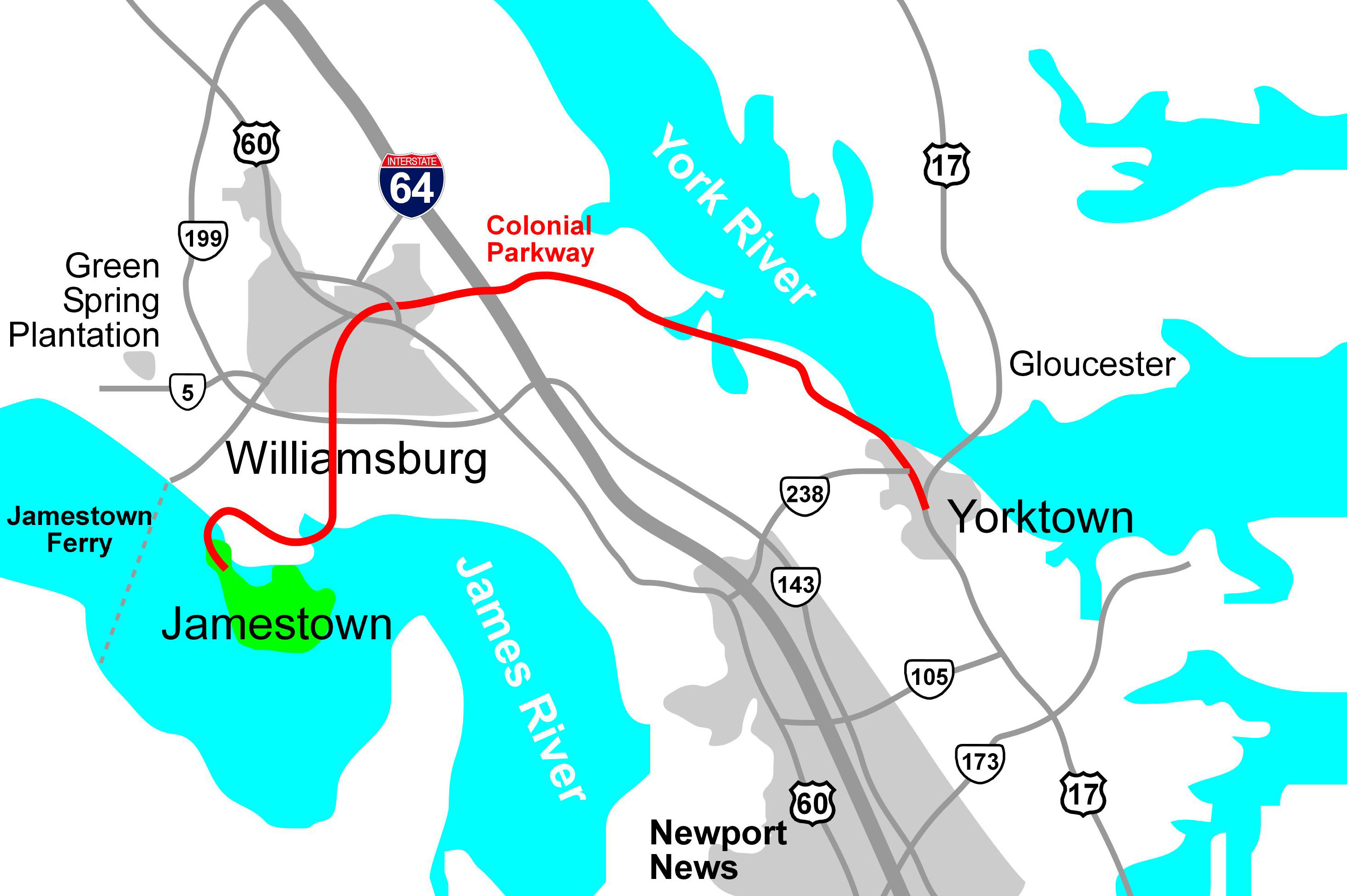
English: Map of the Colonial Parkway, a National Scenic Byway within Colonial National Historical Park in Virginia, drawn in Macromedia Freehand. |
| Date | 30 January 2006 (original upload date) |
| Source | Derived from source file available in http://posix.com/CWmaps, although it is about today's Virginia, not the Civil War |
| Author | Hal Jespersen at en.wikipedia |
| Permission (Reusing this file) |
Released into the public domain (by the author). |
| Other versions | File:Historic Triangle Virginia PNG.png |
Licensing
| Public domainPublic domainfalsefalse |
| |
This work has been released into the public domain by its author, Hal Jespersen, at the English Wikipedia project. This applies worldwide. In case this is not legally possible: |
Original upload log
The original description page was here. All following user names refer to en.wikipedia.
- 2006-01-30 22:25 Hlj 2923×1944× (538422 bytes) Updated the image to correct the location of Green Spring Plantation.
- 2005-10-19 15:50 Hlj 2824×1933× (492287 bytes) Drawn by Hal Jespersen in Macromedia Freehand. Source file available in http://posix.com/CWmaps (although it is about modern Virginia, not the Civil War).
Captions
Add a one-line explanation of what this file represents
Items portrayed in this file
depicts
30 January 2006
File history
Click on a date/time to view the file as it appeared at that time.
| Date/Time | Thumbnail | Dimensions | User | Comment | |
|---|---|---|---|---|---|
| current | 15:22, 24 January 2010 | | 2,923 × 1,944 (526 KB) | BotMultichill | {{BotMoveToCommons|en.wikipedia|year={{subst:CURRENTYEAR}}|month={{subst:CURRENTMONTHNAME}}|day={{subst:CURRENTDAY}}}} {{Information |Description={{en|Drawn by Hal Jespersen in Macromedia Freehand. Source file available in http://posix.com/CWmaps (altho |
File usage
The following pages on the English Wikipedia use this file (pages on other projects are not listed):
Global file usage
The following other wikis use this file:
- Usage on es.wikipedia.org
- Usage on www.wikidata.org
- Usage on zh.wikipedia.org
Metadata
This file contains additional information, probably added from the digital camera or scanner used to create or digitize it.
If the file has been modified from its original state, some details may not fully reflect the modified file.
| Orientation | Normal |
|---|---|
| Horizontal resolution | 300 dpi |
| Vertical resolution | 300 dpi |
| Software used | Adobe Photoshop Elements 4.0 Windows |
| File change date and time | 14:23, 30 January 2006 |
| Color space | sRGB |
Retrieved from "https://en.wikipedia.org/wiki/File:Historic_Triangle_Virginia.jpg"