File:GoughMap_ca_1360.jpg
From Wikipedia, the free encyclopedia
Size of this preview: 800 × 423 pixels. Other resolutions: 320 × 169 pixels | 640 × 339 pixels | 1,096 × 580 pixels.
Original file (1,096 × 580 pixels, file size: 168 KB, MIME type: image/jpeg)
| This is a file from the Wikimedia Commons. Information from its description page there is shown below. Commons is a freely licensed media file repository. You can help. |
Summary
| DescriptionGoughMap ca 1360.jpg |
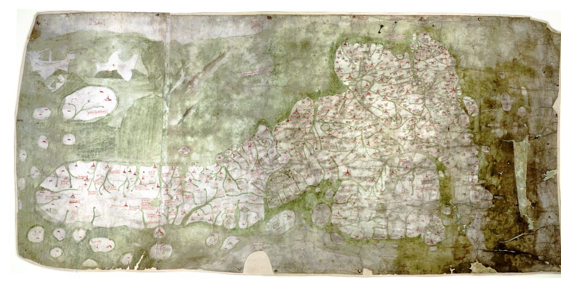
English: The Gough Map or Bodleian Map is a road map of Great Britain, dating from around 1360. The Gough Map is the oldest extant map of the roads of medieval Britain. It is about 115 x 56cm large and was made around 1360. It is named after Richard Gough, who donated the map to the Bodleian Library in 1809. East is on the top. |
| Date |
1370s date QS:P,+1370-00-00T00:00:00Z/8 |
| Source | anonymous, Scan by the Bodleian Library |
| Author | Unknown authorUnknown author |
| Permission (Reusing this file) |
PD-old |
| Other versions | Higher resolution scan at File:Gough_Kaart_(hoge_resolutie).jpg |
.jpg)
| This file comes from the Bodleian Libraries, a group of research libraries in Oxford University. This tag does not indicate the copyright status of the attached work. A normal copyright tag is still required. See Commons:Licensing. |
Links
- The Gough Map Bodleian Library information page
- Britain's first road map Oxford University Magazine 18,2 (2006)
- Interactive Map, joint effort of Queen's University Belfast and Bodleian Library
Licensing
|
This is a faithful photographic reproduction of a two-dimensional, public domain work of art. The work of art itself is in the public domain for the following reason:
The official position taken by the Wikimedia Foundation is that "faithful reproductions of two-dimensional public domain works of art are public domain".
This photographic reproduction is therefore also considered to be in the public domain in the United States. In other jurisdictions, re-use of this content may be restricted; see Reuse of PD-Art photographs for details. | |||||
Captions
Add a one-line explanation of what this file represents
File history
Click on a date/time to view the file as it appeared at that time.
| Date/Time | Thumbnail | Dimensions | User | Comment | |
|---|---|---|---|---|---|
| current | 12:03, 7 May 2007 | | 1,096 × 580 (168 KB) | Mauss | {{Information |Description=The Gough Map or Bodleian Map is a road map of Great Britain, dating from around 1360. |Source= |Date= |Author= |Permission=PD-old |other_versions= }} |
File usage
The following pages on the English Wikipedia use this file (pages on other projects are not listed):
Global file usage
The following other wikis use this file:
- Usage on hr.wikipedia.org
- Usage on sh.wikipedia.org
Metadata
This file contains additional information, probably added from the digital camera or scanner used to create or digitize it.
If the file has been modified from its original state, some details may not fully reflect the modified file.
| _error | 0 |
|---|
Retrieved from "https://en.wikipedia.org/wiki/File:GoughMap_ca_1360.jpg"