File:Germany_(2),_Neuwerk,_Scharhörn,_Nigehörn.jpg
From Wikipedia, the free encyclopedia
Size of this preview: 691 × 600 pixels. Other resolutions: 277 × 240 pixels | 553 × 480 pixels | 885 × 768 pixels | 1,180 × 1,024 pixels | 1,941 × 1,684 pixels.
Original file (1,941 × 1,684 pixels, file size: 550 KB, MIME type: image/jpeg)
| This is a file from the Wikimedia Commons. Information from its description page there is shown below. Commons is a freely licensed media file repository. You can help. |
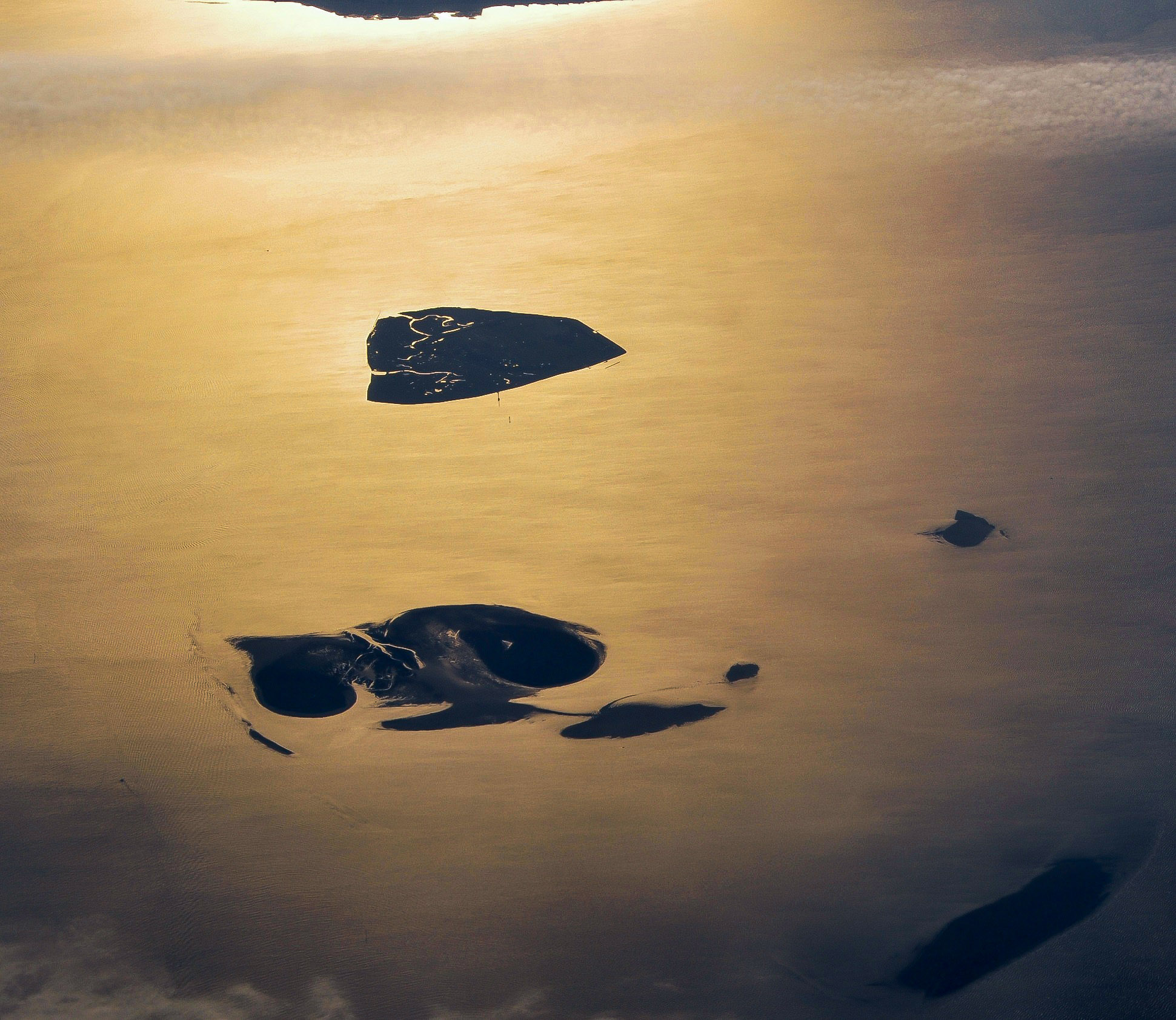
Summary
| DescriptionGermany (2), Neuwerk, Scharhörn, Nigehörn.jpg |
English: Aerial picture of the Hamburg Wadden Sea National Park (German: Nationalpark Hamburgisches Wattenmeer). This park is an exclave of the city state of Hamburg and lies 12.5 km off Cuxhaven in the estuary of the Elbe in the North Sea. The park includes the islands of Neuwerk (above), Scharhörn and Nigehörn (below, appearing as a single island in this picture taken at low tide). The two other islands (right and below right) are parts of the Scharhörn and Neuwerk mudflats (Scharhörner und Neuwerker Watt). Viewing direction is toward the SE.
Nederlands: Luchtfoto van het Hamburgse Nationale Park Waddenzee (Duits: Nationalpark Hamburgisches Wattenmeer). Dit park is een exclave van de stadstaat Hamburg en ligt 12.5 ten NW van Cuxhaven in de monding van de Elbe in de Noordzee. Het park omvat de eilanden Neuwerk (boven), Scharhörn en Nigehörn (die op de foto op één eiland lijken). De twee andere eilanden (rechts en rechts onder) zijn delen van het Scharhörnse en Neuwerkse Wad (Scharhörner und Neuwerker Watt). Blikrichting is naar het zuidoosten. |
| Date | |
| Source | Own work |
| Author | Vincent van Zeijst |
| Permission (Reusing this file) |
This file is licensed under the Creative Commons Attribution-Share Alike 3.0 Unported license.
|
| Camera location | 53° 59′ 53.1″ N, 8° 20′ 19.04″ E | View this and other nearby images on: OpenStreetMap |
|---|
| Annotations InfoField | This image is annotated: View the annotations at Commons |
402
3
520
53
1941
1684
Cuxhaven
3
3
152
1370
1941
1684
Elbe
Captions
Add a one-line explanation of what this file represents
Items portrayed in this file
depicts
18 October 2010
53°59'53.099"N, 8°20'19.039"E
File history
Click on a date/time to view the file as it appeared at that time.
| Date/Time | Thumbnail | Dimensions | User | Comment | |
|---|---|---|---|---|---|
| current | 13:59, 27 December 2017 | | 1,941 × 1,684 (550 KB) | Aeroid | dust removal |
| 16:59, 26 March 2011 |  | 1,941 × 1,684 (543 KB) | Loranchet | {{Information |Description ={{en|1=Aerial picture of the Hamburg Wadden Sea National Park (German: Nationalpark Hamburgisches Wattenmeer). This park is an exclave of the city state of Hamburg and lies 12.5 km off Cuxhaven in the estuary of the Elbe in |
File usage
The following pages on the English Wikipedia use this file (pages on other projects are not listed):
Global file usage
The following other wikis use this file:
- Usage on az.wikipedia.org
- Usage on ban.wikipedia.org
- Usage on de.wikipedia.org
- Usage on fa.wikipedia.org
- Usage on hsb.wikipedia.org
- Usage on mk.wikipedia.org
- Usage on nl.wikipedia.org
- Usage on pl.wikipedia.org
- Usage on sv.wikipedia.org
- Usage on tr.wikipedia.org
- Usage on ur.wikipedia.org
- Usage on vi.wikipedia.org
- Usage on zh.wikipedia.org
Metadata
This file contains additional information, probably added from the digital camera or scanner used to create or digitize it.
If the file has been modified from its original state, some details may not fully reflect the modified file.
| Camera manufacturer | NIKON CORPORATION |
|---|---|
| Camera model | NIKON D5000 |
| Exposure time | 1/500 sec (0.002) |
| F-number | f/11 |
| ISO speed rating | 200 |
| Date and time of data generation | 08:40, 18 October 2010 |
| Lens focal length | 52 mm |
| Width | 1,941 px |
| Height | 1,684 px |
| Bits per component |
|
| Pixel composition | RGB |
| Orientation | Normal |
| Number of components | 3 |
| Horizontal resolution | 300 dpi |
| Vertical resolution | 300 dpi |
| Software used | Adobe Photoshop CC (Windows) |
| File change date and time | 14:48, 27 December 2017 |
| Y and C positioning | Co-sited |
| Exposure Program | Not defined |
| Exif version | 2.21 |
| Date and time of digitizing | 08:40, 18 October 2010 |
| Meaning of each component |
|
| Image compression mode | 2 |
| Shutter speed | 8.965784 |
| APEX aperture | 6.918863 |
| Exposure bias | 0 |
| Maximum land aperture | 4.6 APEX (f/4.92) |
| Metering mode | Pattern |
| Light source | Unknown |
| Flash | Flash did not fire, auto mode |
| DateTime subseconds | 50 |
| DateTimeOriginal subseconds | 50 |
| DateTimeDigitized subseconds | 50 |
| Supported Flashpix version | 1 |
| Color space | sRGB |
| Sensing method | One-chip color area sensor |
| File source | Digital still camera |
| Scene type | A directly photographed image |
| Custom image processing | Normal process |
| Exposure mode | Auto exposure |
| White balance | Auto white balance |
| Digital zoom ratio | 1 |
| Focal length in 35 mm film | 78 mm |
| Scene capture type | Standard |
| Scene control | None |
| Contrast | Normal |
| Saturation | Normal |
| Sharpness | Normal |
| Subject distance range | Unknown |
| GPS tag version | 2.2.0.0 |
| Serial number of camera | 6300062 |
| Lens used | 18.0-105.0 mm f/3.5-5.6 |
| Date metadata was last modified | 15:48, 27 December 2017 |
| Unique ID of original document | E5C54542543F661DF11EA16F84B46692 |
,_Neuwerk,_Scharhörn,_Nigehörn.jpg)