File:FrobisherBayOMC.png
From Wikipedia, the free encyclopedia
No higher resolution available.
FrobisherBayOMC.png (496 × 496 pixels, file size: 17 KB, MIME type: image/png)
| This is a file from the Wikimedia Commons. Information from its description page there is shown below. Commons is a freely licensed media file repository. You can help. |
Summary
| DescriptionFrobisherBayOMC.png |
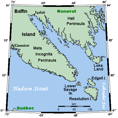
English: A map showing Frobisher Bay and nearby areas. This map's source is here, with the uploader's modifications, and the GMT homepage says that the tools are released under the GNU General Public License. |
| Date | 12 July 2007 (original upload date) |
| Source | Transferred from en.wikipedia to Commons. |
| Author | Kelisi at English Wikipedia |
Licensing
Kelisi at the English-language Wikipedia, the copyright holder of this work, hereby publishes it under the following license:
| This file is licensed under the Creative Commons Attribution-Share Alike 3.0 Unported license. Subject to disclaimers. | ||
| Attribution: Kelisi at the English-language Wikipedia | ||
| ||
| This licensing tag was added to this file as part of the GFDL licensing update.http://creativecommons.org/licenses/by-sa/3.0/CC BY-SA 3.0Creative Commons Attribution-Share Alike 3.0truetrue |

|
Permission is granted to copy, distribute and/or modify this document under the terms of the GNU Free Documentation License, Version 1.2 or any later version published by the Free Software Foundation; with no Invariant Sections, no Front-Cover Texts, and no Back-Cover Texts. A copy of the license is included in the section entitled GNU Free Documentation License. Subject to disclaimers.http://www.gnu.org/copyleft/fdl.htmlGFDLGNU Free Documentation Licensetruetrue |
Original upload log
The original description page was here. All following user names refer to en.wikipedia.
- 2007-07-12 19:16 Kelisi 496×496×8 (17371 bytes)
- 2007-07-12 16:43 Kelisi 493×496×8 (16903 bytes) == Summary == A map showing Frobisher Bay and nearby areas. This map's source is [http://www.aquarius.ifm-geomar.de/ here], with the uploader's modifications, and the [http://gmt.soest.hawaii.edu/ GMT homepage] says that the tools are released under the G
Captions
Add a one-line explanation of what this file represents
Items portrayed in this file
depicts
12 July 2007
File history
Click on a date/time to view the file as it appeared at that time.
| Date/Time | Thumbnail | Dimensions | User | Comment | |
|---|---|---|---|---|---|
| current | 17:58, 10 July 2008 | | 496 × 496 (17 KB) | Urdangaray | {{Information |Description={{en|A map showing Frobisher Bay and nearby areas. This map's source is [http://www.aquarius.ifm-geomar.de/ here], with the uploader's modifications, and the [http://gmt.soest.hawaii.edu/ GMT homepage] says that the tools are re |
File usage
The following pages on the English Wikipedia use this file (pages on other projects are not listed):
Global file usage
The following other wikis use this file:
- Usage on ca.wikipedia.org
- Usage on ckb.wikipedia.org
- Usage on da.wikipedia.org
- Usage on de.wikipedia.org
- Usage on es.wikipedia.org
- Usage on fa.wikipedia.org
- Usage on hu.wikipedia.org
- Usage on it.wikipedia.org
- Usage on ja.wikipedia.org
- Usage on lfn.wikipedia.org
- Usage on ml.wikipedia.org
- Usage on nn.wikipedia.org
- Usage on no.wikipedia.org
Retrieved from "https://en.wikipedia.org/wiki/File:FrobisherBayOMC.png"