File:Fire-island-map.jpg
From Wikipedia, the free encyclopedia
Original file (3,493 × 1,382 pixels, file size: 363 KB, MIME type: image/jpeg)
| This is a file from the Wikimedia Commons. Information from its description page there is shown below. Commons is a freely licensed media file repository. You can help. |
Summary
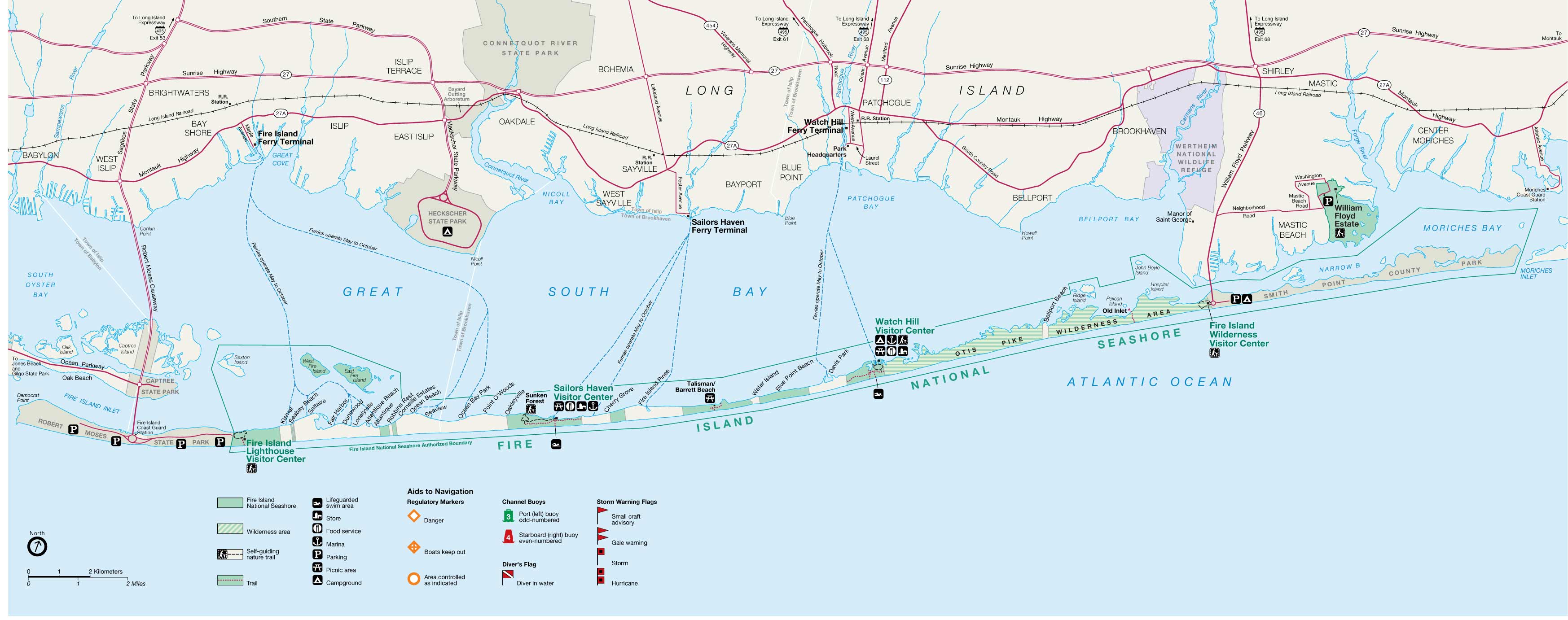
| DescriptionFire-island-map.jpg |
English: Fire Island map from USGS |
|||||
| Source | http://ny.cf.er.usgs.gov/nyprojectsearch/projects/2457-BUF-1.html | |||||
| Creator |
United States Geological Survey / Fire Island Inlet National Park |
|||||
| Georeferencing | Georeference the map in Wikimaps Warper If inappropriate please set warp_status = skip to hide. | |||||
| Other versions |
|


Licensing
| Public domainPublic domainfalsefalse |
This image is in the public domain in the United States because it only contains materials that originally came from the United States Geological Survey, an agency of the United States Department of the Interior. For more information, see the official USGS copyright policy.
Bahasa Indonesia ∙ català ∙ čeština ∙ Deutsch ∙ eesti ∙ English ∙ español ∙ français ∙ galego ∙ italiano ∙ Nederlands ∙ português ∙ polski ∙ sicilianu ∙ suomi ∙ Tiếng Việt ∙ Türkçe ∙ български ∙ македонски ∙ русский ∙ മലയാളം ∙ 한국어 ∙ 日本語 ∙ 中文 ∙ 中文(简体) ∙ 中文(繁體) ∙ العربية ∙ فارسی ∙ +/− |
Original upload log
Transferred from en.wikipedia to Commons by Vmenkov using CommonsHelper.
- 2007-11-21 10:21 Americasroof 3493×1382× (371827 bytes) [[Fire Island, New York]] map from USGS http://ny.cf.er.usgs.gov/nyprojectsearch/projects/projectImages/2457-BUF-1_image002.jpg
Captions
Items portrayed in this file
depicts
image/jpeg
File history
Click on a date/time to view the file as it appeared at that time.
| Date/Time | Thumbnail | Dimensions | User | Comment | |
|---|---|---|---|---|---|
| current | 00:50, 11 June 2011 | 3,493 × 1,382 (363 KB) | File Upload Bot (Magnus Manske) | {{BotMoveToCommons|en.wikipedia|year={{subst:CURRENTYEAR}}|month={{subst:CURRENTMONTHNAME}}|day={{subst:CURRENTDAY}}}} {{Information |Description={{en|en:Fire Island, New York map from USGS}} |Source=Transferred from [http://en.wikipedia.org en.wik |
File usage
- Fair Harbor, New York
- Fire Island
- Fire Island National Seashore
- Fire Island Pines, New York
- List of municipalities on Long Island
- Lonelyville, New York
- Moriches Bay
- Patchogue Bay
- Saltaire, New York
- Watch Hill (New York)
- Module:Location map/data/USA New York Fire Island
- Module:Location map/data/USA New York Fire Island/doc
Global file usage
The following other wikis use this file:
- Usage on ar.wikipedia.org
- Usage on ceb.wikipedia.org
- Usage on de.wikipedia.org
- Usage on fa.wikipedia.org
- Usage on fr.wikipedia.org
- Usage on it.wikipedia.org
- Usage on pl.wikipedia.org
- Usage on si.wikipedia.org
- Usage on war.wikipedia.org
- Usage on www.wikidata.org
- Usage on zh.wikipedia.org
Metadata
This file contains additional information, probably added from the digital camera or scanner used to create or digitize it.
If the file has been modified from its original state, some details may not fully reflect the modified file.
| _error | 0 |
|---|