File:Europe_1815_map_de.png
From Wikipedia, the free encyclopedia
Size of this preview: 800 × 526 pixels. Other resolutions: 320 × 211 pixels | 640 × 421 pixels | 1,024 × 674 pixels | 1,280 × 842 pixels | 2,284 × 1,503 pixels.
Original file (2,284 × 1,503 pixels, file size: 1.07 MB, MIME type: image/png)
| This is a file from the Wikimedia Commons. Information from its description page there is shown below. Commons is a freely licensed media file repository. You can help. |
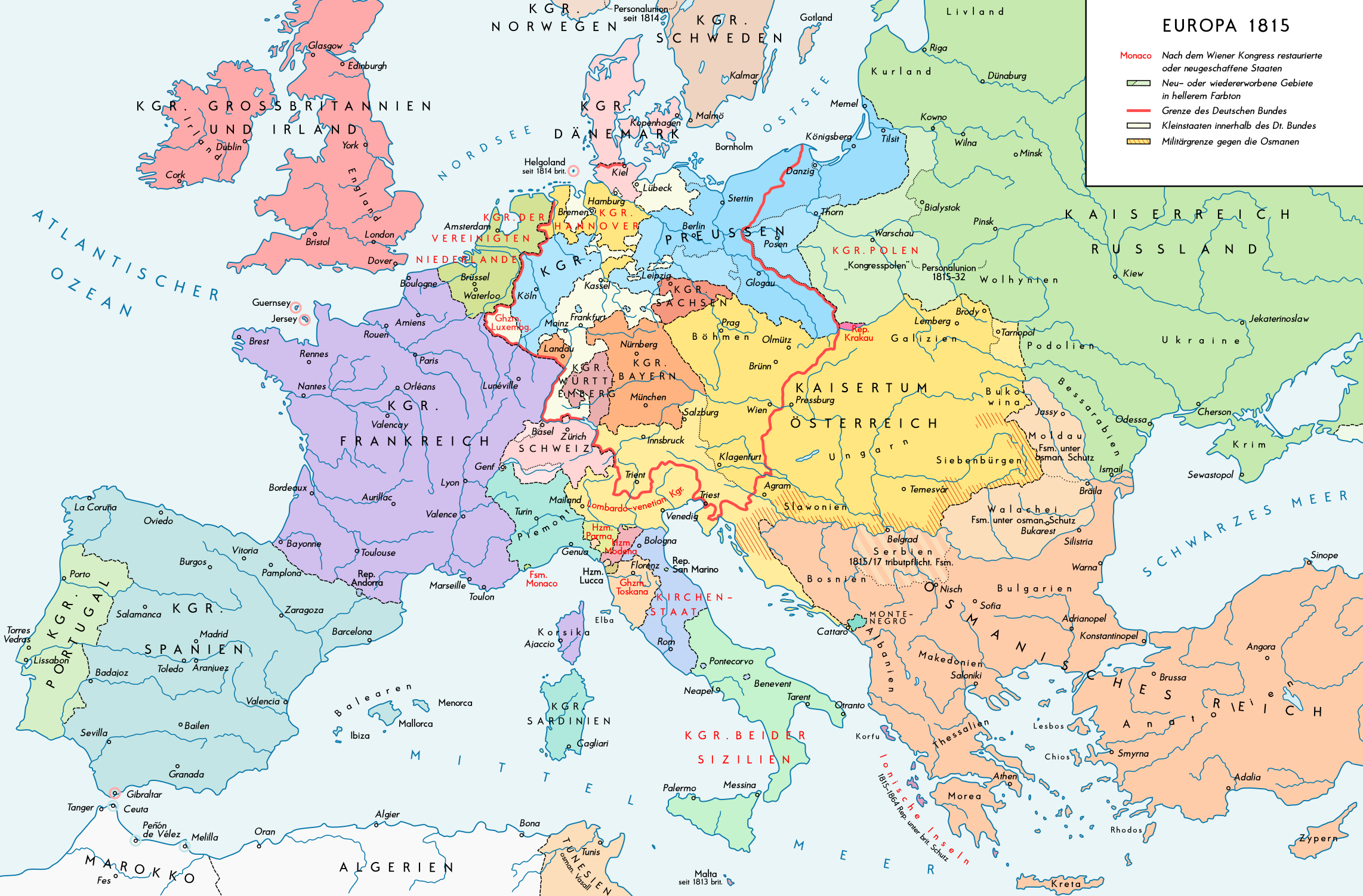
Summary
| DescriptionEurope 1815 map de.png |
English: Europe 1815. Political situation after the Congress of Vienna in June 1815. Please don't alter the map, when you think there something not written or depicted correctly. Leave a message at the talk page of the file. After a verificiation and a possible discussion, i will upload a new map version with all new changes. This prevents an unnecessary waste of disc space and ensure a good result, aesthetically and contentwise. - The author. Deutsch: Europa 1815. Politische Lage nach dem Wiener Kongress im Juni 1815. Bitte die Karte bei Änderungs- und Korrekturwünschen nicht selbst verändern, sondern eine Anmerkung im Diskussionsbereich der Bilddatei hinterlassen. Nach einer Prüfung und ggfs. Diskussion werden evtl. Änderungen von mir zusammengefasst eingearbeitet. Das vermeidet unnötige Speicherplatz-Verschwendung und gewährleistet ein ästhetisch ansprechendes und inhaltlich korrektes Ergebnis. - Der Urheber. |
| Date | |
| Source |
Own work. Source of Information: Historical atlases – Map "1815 - L'Europe apès le Congrès de Vienne" (Author unknown)(Link) – Ramsay Muir, George Philip (ed.): Philip's New School Atlas of Universal History, George Philip & Son, Ltd., London 1928 – Dr. Walter Leisering (ed.): Putzger Historischer Weltatlas, Cornelsen Verlag, Berlin 1992, ISBN 3-464-00176-8 – Bayerischer Schulbuch-Verlag (ed.): Großer Historischer Weltatlas, Dritter Teil, Neuzeit, Bayerischer Schulbuch-Verlag, München 1981, ISBN 3-7627-6021-7. – Prof. Dr. Hans-Erich Stier, Prof. Dr. Ernst Kirsten a. o. (ed.): Großer Atlas zur Weltgeschichte, Orbis Verlag, München 1990, ISBN 3-7627-6021-7 Other publications – Reinhard Stauber: Der Wiener Kongress, Böhlau Verlag, Wien/Köln/Weimar 2014, ISBN 978-3-8252-4095-0 – Thierry Lentz: 1815. Der Wiener Kongress und die Neugründung Europas, Siedler Verlag, München 2014, ISBN 978-3-8275-0027-4 |
| Author | Alexander Altenhof |
| Other versions |
|

Recompressed without quality loss with OptiPNG (1.36 MB > 1.06 MB)
Licensing
This file is licensed under the Creative Commons Attribution-Share Alike 4.0 International license.
- You are free:
- to share – to copy, distribute and transmit the work
- to remix – to adapt the work
- Under the following conditions:
- attribution – You must give appropriate credit, provide a link to the license, and indicate if changes were made. You may do so in any reasonable manner, but not in any way that suggests the licensor endorses you or your use.
- share alike – If you remix, transform, or build upon the material, you must distribute your contributions under the same or compatible license as the original.

|
This map image could be re-created using vector graphics as an SVG file. This has several advantages; see Commons:Media for cleanup for more information. If an SVG form of this image is available, please upload it and afterwards replace this template with
{{vector version available|new image name}}.
It is recommended to name the SVG file “Europe 1815 map de.svg”—then the template Vector version available (or Vva) does not need the new image name parameter. |
Captions
Add a one-line explanation of what this file represents
Items portrayed in this file
depicts
some value
20 July 2016
File history
Click on a date/time to view the file as it appeared at that time.
| Date/Time | Thumbnail | Dimensions | User | Comment | |
|---|---|---|---|---|---|
| current | 23:37, 14 April 2017 | | 2,284 × 1,503 (1.07 MB) | KaterBegemot | Minor changes |
| 21:51, 11 September 2016 |  | 2,284 × 1,503 (1.35 MB) | KaterBegemot | Kingdom of Spain same green color like in the other maps | |
| 21:39, 11 September 2016 |  | 2,284 × 1,503 (1.06 MB) | KaterBegemot | Deleted black border at Austrian part of the German Confederation border, P. of Monaco smaller, corrected border at Tarnopol area, changed spacing of K. of Netherlands text | |
| 11:28, 20 July 2016 |  | 2,284 × 1,503 (1.06 MB) | KaterBegemot | {{Information |Description ={{en|1=Europe 1815. Political situation after the Congress of Vienna in June 1815.<br> ''Please don't alter the map, when you think there something not written or depicted correclty. Leave a mes... |
File usage
No pages on the English Wikipedia use this file (pages on other projects are not listed).
Global file usage
The following other wikis use this file:
- Usage on bg.wikipedia.org
- Usage on de.wikipedia.org
- Usage on lv.wikipedia.org
- Usage on pt.wikipedia.org
Metadata
This file contains additional information, probably added from the digital camera or scanner used to create or digitize it.
If the file has been modified from its original state, some details may not fully reflect the modified file.
| Horizontal resolution | 70 dpi |
|---|---|
| Vertical resolution | 70 dpi |
| Color space | Uncalibrated |
| Image width | 2,284 px |
| Image height | 1,503 px |
| Software used | Adobe Photoshop CC 2017 (Windows) |
| Date and time of digitizing | 00:31, 15 April 2017 |
| File change date and time | 03:16, 15 April 2017 |
| Date metadata was last modified | 03:16, 15 April 2017 |
| Unique ID of original document | xmp.did:42cb4f16-85a2-0644-8c5d-9648733bc557 |
Retrieved from "https://en.wikipedia.org/wiki/File:Europe_1815_map_de.png"