File:EF4_Damage_-_190_MPH_in_Bremen,_Kentucky.jpg
From Wikipedia, the free encyclopedia
Size of this preview: 800 × 600 pixels. Other resolutions: 320 × 240 pixels | 640 × 480 pixels | 1,024 × 768 pixels | 1,280 × 960 pixels | 2,560 × 1,920 pixels | 4,032 × 3,024 pixels.
Original file (4,032 × 3,024 pixels, file size: 5.19 MB, MIME type: image/jpeg)
| This is a file from the Wikimedia Commons. Information from its description page there is shown below. Commons is a freely licensed media file repository. You can help. |
Summary
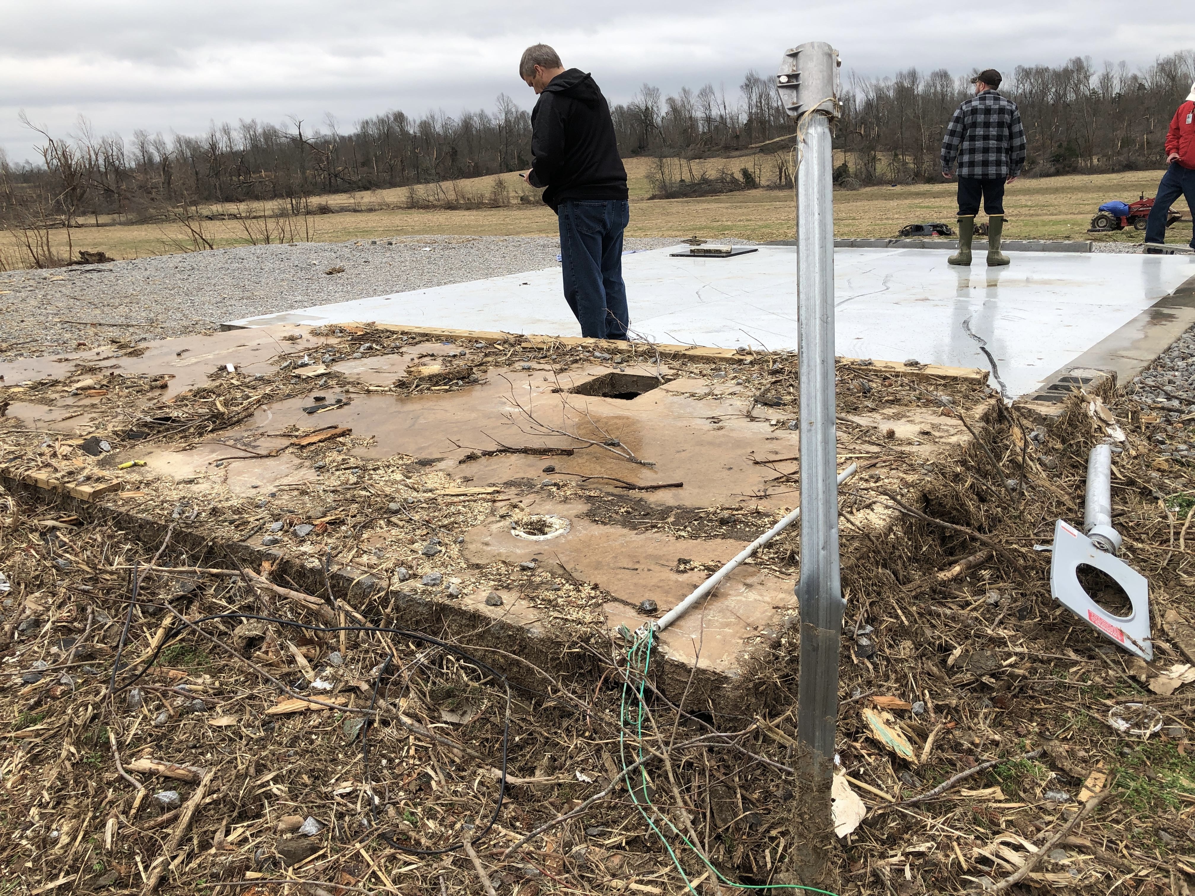
| DescriptionEF4 Damage - 190 MPH in Bremen, Kentucky.jpg |
English: EF4 damage in Bremen, Kentucky, rated at 190 mph, the highest intensity of the tornado. |
| Date | |
| Source | https://apps.dat.noaa.gov/stormdamage/damageviewer/ |
| Author | National Oceanic and Atmospheric Administration |
| Camera location | 37° 21′ 14.3″ N, 87° 16′ 06.22″ W | View this and other nearby images on: OpenStreetMap |
|---|
Licensing
| Public domainPublic domainfalsefalse |
This image is in the public domain because it contains materials that originally came from the U.S. National Oceanic and Atmospheric Administration, taken or made as part of an employee's official duties.
العربية ∙ čeština ∙ Deutsch ∙ Zazaki ∙ English ∙ español ∙ eesti ∙ suomi ∙ français ∙ hrvatski ∙ magyar ∙ italiano ∙ 日本語 ∙ 한국어 ∙ македонски ∙ മലയാളം ∙ Plattdüütsch ∙ Nederlands ∙ polski ∙ português ∙ română ∙ русский ∙ sicilianu ∙ slovenščina ∙ Türkçe ∙ Tiếng Việt ∙ 简体中文 ∙ 繁體中文 ∙ +/− |
Captions
EF4 damage in Bremen, Kentucky, rated at 190 mph, the highest intensity of the tornado.
Items portrayed in this file
depicts
37°21'14.299"N, 87°16'6.218"W
0.00181159420289855072 second
1.8
3.99 millimetre
image/jpeg
File history
Click on a date/time to view the file as it appeared at that time.
| Date/Time | Thumbnail | Dimensions | User | Comment | |
|---|---|---|---|---|---|
| current | 05:27, 23 October 2022 | | 4,032 × 3,024 (5.19 MB) | WeatherWriter | Uploaded a work by National Oceanic and Atmospheric Administration from https://apps.dat.noaa.gov/stormdamage/damageviewer/ with UploadWizard |
File usage
The following pages on the English Wikipedia use this file (pages on other projects are not listed):
Metadata
This file contains additional information, probably added from the digital camera or scanner used to create or digitize it.
If the file has been modified from its original state, some details may not fully reflect the modified file.
| Camera manufacturer | Apple |
|---|---|
| Camera model | iPhone 8 |
| Exposure time | 1/552 sec (0.0018115942028986) |
| F-number | f/1.8 |
| ISO speed rating | 20 |
| Date and time of data generation | 12:53, 16 December 2021 |
| Lens focal length | 3.99 mm |
| Latitude | 37° 21′ 14.3″ N |
| Longitude | 87° 16′ 6.22″ W |
| Altitude | 120.756 meters above sea level |
| Orientation | Normal |
| Horizontal resolution | 72 dpi |
| Vertical resolution | 72 dpi |
| Software used | ArcGIS Survey123 |
| File change date and time | 12:53, 16 December 2021 |
| Y and C positioning | Centered |
| Exposure Program | Normal program |
| Exif version | 2.32 |
| Date and time of digitizing | 12:53, 16 December 2021 |
| Meaning of each component |
|
| Shutter speed | 9.1074053656744 |
| APEX aperture | 1.6959938128384 |
| APEX brightness | 7.981410655519 |
| Exposure bias | 0 |
| Metering mode | Pattern |
| Flash | Flash did not fire, compulsory flash suppression |
| DateTimeOriginal subseconds | 264 |
| DateTimeDigitized subseconds | 264 |
| Supported Flashpix version | 1 |
| Color space | sRGB |
| Sensing method | One-chip color area sensor |
| Scene type | 0 |
| Exposure mode | Auto exposure |
| White balance | Auto white balance |
| Focal length in 35 mm film | 28 mm |
| Scene capture type | Standard |
| Speed unit | Kilometers per hour |
| Speed of GPS receiver | 2.16 |
| Reference for direction of movement | True direction |
| Direction of movement | 185.97660013765 |
| Reference for direction of image | Magnetic direction |
| Direction of image | 26.82 |
| Geodetic survey data used | WGS-84 |
| GPS tag version | 2.3.0.0 |