File:Democratic_Republic_of_Georgia_map.jpg
From Wikipedia, the free encyclopedia
Size of this preview: 800 × 561 pixels. Other resolutions: 320 × 224 pixels | 640 × 448 pixels | 1,024 × 718 pixels | 1,213 × 850 pixels.
Original file (1,213 × 850 pixels, file size: 442 KB, MIME type: image/jpeg)
| This is a file from the Wikimedia Commons. Information from its description page there is shown below. Commons is a freely licensed media file repository. You can help. |

|
This history map image could be re-created using vector graphics as an SVG file. This has several advantages; see Commons:Media for cleanup for more information. If an SVG form of this image is available, please upload it and afterwards replace this template with
{{vector version available|new image name}}.
It is recommended to name the SVG file “Democratic Republic of Georgia map.svg”—then the template Vector version available (or Vva) does not need the new image name parameter. |
 | This history map image was uploaded in the JPEG format even though it consists of non-photographic data. This information could be stored more efficiently or accurately in the PNG or SVG format. If possible, please upload a PNG or SVG version of this image without compression artifacts, derived from a non-JPEG source (or with existing artifacts removed). After doing so, please tag the JPEG version with {{Superseded|NewImage.ext}} and remove this tag. This tag should not be applied to photographs or scans. If this image is a diagram or other image suitable for vectorisation, please tag this image with {{Convert to SVG}} instead of {{BadJPEG}}. If not suitable for vectorisation, use {{Convert to PNG}}. For more information, see {{BadJPEG}}. |  |
Summary
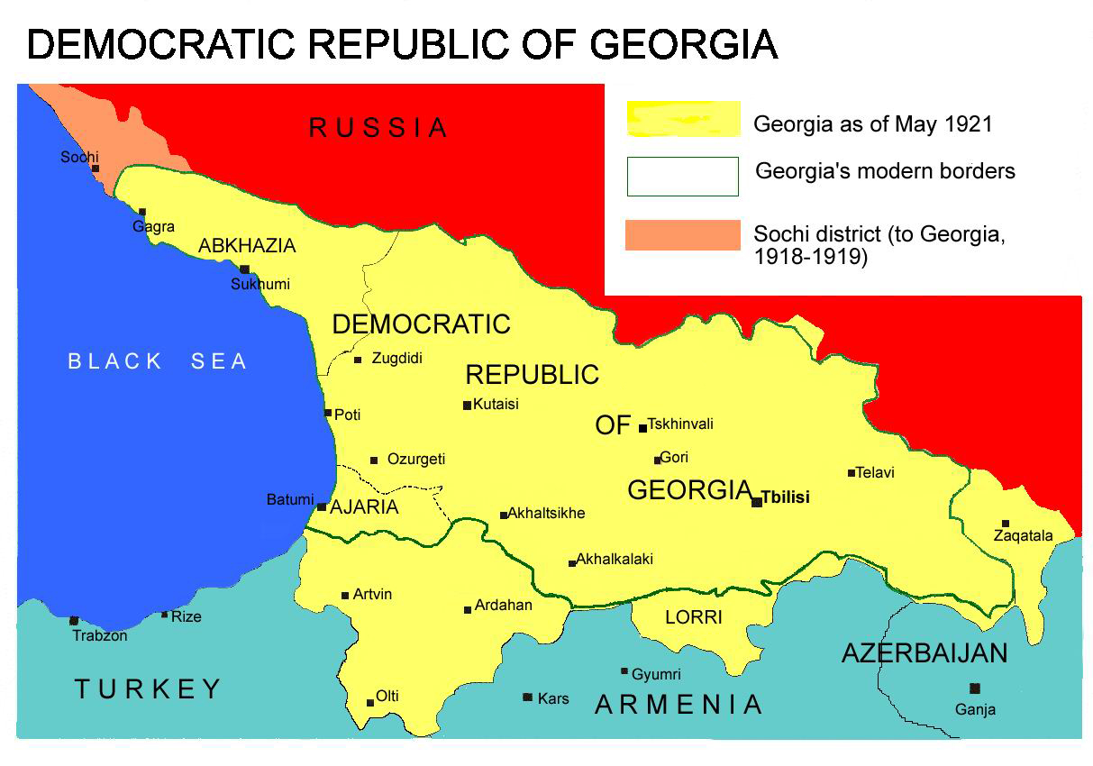
Democratic Republic of Georgia map, 1918-1921
Source: english wikipedia
Uploaded by user:Kober
Licensing
| Public domainPublic domainfalsefalse |
| I, the copyright holder of this work, release this work into the public domain. This applies worldwide. In some countries this may not be legally possible; if so: I grant anyone the right to use this work for any purpose, without any conditions, unless such conditions are required by law. |
Captions
Add a one-line explanation of what this file represents
Items portrayed in this file
depicts
File history
Click on a date/time to view the file as it appeared at that time.
| Date/Time | Thumbnail | Dimensions | User | Comment | |
|---|---|---|---|---|---|
| current | 13:26, 7 April 2013 | | 1,213 × 850 (442 KB) | Giorgi Balakhadze | At that time (May, 1921 year) there was no South Ossetia, it was created in 1922. |
| 13:21, 7 April 2013 |  | 1,213 × 850 (442 KB) | Giorgi Balakhadze | Reverted to version as of 13:08, 7 April 2013 | |
| 13:15, 7 April 2013 |  | 1,213 × 850 (442 KB) | Giorgi Balakhadze | At that time (1921 year) there was no South Ossetia, it was created 1922. | |
| 13:08, 7 April 2013 |  | 1,213 × 850 (442 KB) | Giorgi Balakhadze | At that time (1921 year) there was no South Osetia. | |
| 16:46, 26 December 2005 |  | 1,213 × 850 (111 KB) | Hardscarf | Democratic Republic of Georgia map, 1918-1921 Source: [http://en.wikipedia.org/wiki/Image:Democratic_Republic_of_Georgia_map.jpg english wikipedia] Uploaded by [http://en.wikipedia.org/wiki/User:Kober user:Kober] Category:Historical maps of Georgia |
File usage
The following pages on the English Wikipedia use this file (pages on other projects are not listed):
Global file usage
The following other wikis use this file:
- Usage on bg.wikipedia.org
- Usage on bn.wikipedia.org
- Usage on da.wikipedia.org
- Usage on de.wikipedia.org
- Usage on en.wikibooks.org
- Usage on fa.wikipedia.org
- Usage on id.wikipedia.org
- Usage on ka.wikipedia.org
- Usage on lt.wikipedia.org
- Usage on pl.wikipedia.org
- Usage on pnb.wikipedia.org
- Usage on pt.wikipedia.org
- Usage on ru.wikipedia.org
- Usage on sk.wikipedia.org
- Usage on sr.wikipedia.org
- Usage on tr.wikipedia.org
- Usage on uk.wikipedia.org
- Usage on ur.wikipedia.org
- Usage on zh.wikipedia.org
Metadata
This file contains additional information, probably added from the digital camera or scanner used to create or digitize it.
If the file has been modified from its original state, some details may not fully reflect the modified file.
| Width | 1,213 px |
|---|---|
| Height | 850 px |
| Bits per component |
|
| Pixel composition | RGB |
| Orientation | Normal |
| Number of components | 3 |
| Horizontal resolution | 72 dpi |
| Vertical resolution | 72 dpi |
| Software used | Adobe Photoshop CS6 (Windows) |
| File change date and time | 16:10, 7 April 2013 |
| Y and C positioning | Centered |
| Exif version | 2.1 |
| DateTime subseconds | 515 |
| Color space | sRGB |
| Date and time of digitizing | 18:51, 7 April 2013 |
| Date metadata was last modified | 19:10, 7 April 2013 |
| Unique ID of original document | FCF3FDC806A2386E48A606333C59073A |
| IIM version | 12,000 |