File:DST_Countries_Map.png
From Wikipedia, the free encyclopedia
Size of this preview: 800 × 355 pixels. Other resolutions: 320 × 142 pixels | 640 × 284 pixels | 1,024 × 454 pixels | 1,280 × 568 pixels | 2,560 × 1,136 pixels | 4,952 × 2,197 pixels.
Original file (4,952 × 2,197 pixels, file size: 462 KB, MIME type: image/png)
| This is a file from the Wikimedia Commons. Information from its description page there is shown below. Commons is a freely licensed media file repository. You can help. |
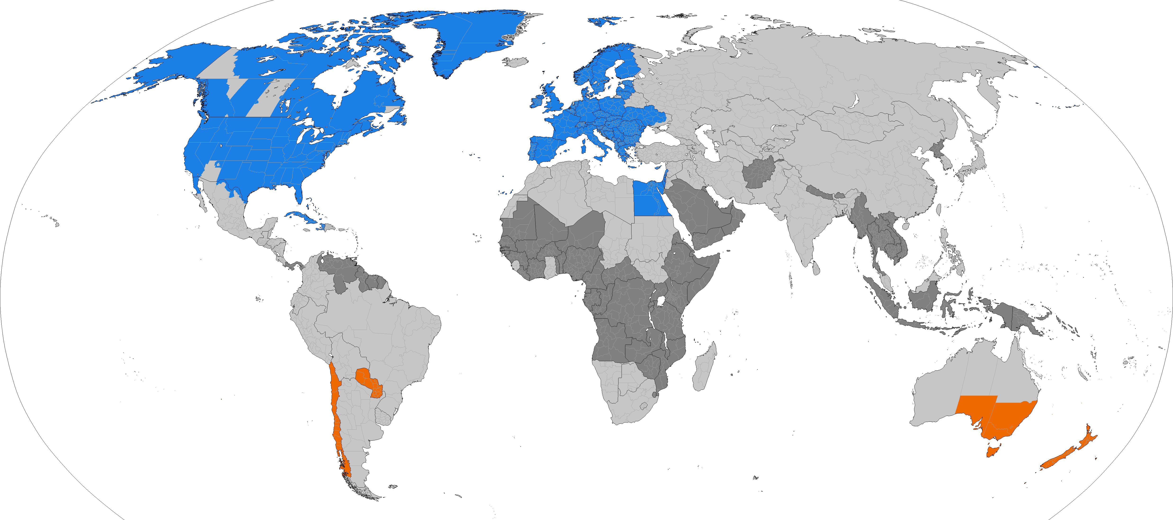
Dark grey places have never used daylight savings, light grey places formerly used it. Orange places use daylight savings in the southern hemisphere summer. Blue places use daylight savings in the northern hemisphere summer.

|
This file may be updated to reflect new information. If you wish to use a specific version of the file without new updates being mirrored, please upload the required version as a separate file. |

|
This map of the world image could be re-created using vector graphics as an SVG file. This has several advantages; see Commons:Media for cleanup for more information. If an SVG form of this image is available, please upload it and afterwards replace this template with
{{vector version available|new image name}}.
It is recommended to name the SVG file “DST Countries Map.svg”—then the template Vector version available (or Vva) does not need the new image name parameter. |
Summary
| DescriptionDST Countries Map.png |
English: Larger map of the previous version. Distinguished from summertime in the northern hemisphere and southern hemisphere.
|
| Date | |
| Source | Own work |
| Author | TimeZonesBoy |
| Other versions |
Supplementary map: |

Licensing
I, the copyright holder of this work, hereby publish it under the following license:
This file is licensed under the Creative Commons Attribution-Share Alike 3.0 Unported license.
- You are free:
- to share – to copy, distribute and transmit the work
- to remix – to adapt the work
- Under the following conditions:
- attribution – You must give appropriate credit, provide a link to the license, and indicate if changes were made. You may do so in any reasonable manner, but not in any way that suggests the licensor endorses you or your use.
- share alike – If you remix, transform, or build upon the material, you must distribute your contributions under the same or compatible license as the original.
Captions
Countries that observe Daylight Saving Time
Länder, die Sommerzeit benutzen
Los países que observan el horario de verano
Items portrayed in this file
depicts
some value
30 May 2013
image/png
File history
Click on a date/time to view the file as it appeared at that time.
| Date/Time | Thumbnail | Dimensions | User | Comment | |
|---|---|---|---|---|---|
| current | 06:06, 31 March 2024 | | 4,952 × 2,197 (462 KB) | Heitordp | Adjusted Greenland |
| 11:27, 31 December 2023 |  | 4,952 × 2,197 (462 KB) | Heitordp | Updated Greenland, disputed borders, subdivisions of France, Morocco, DR Congo, South Sudan, Ethiopia, Somalia, India | |
| 09:44, 23 April 2023 |  | 4,952 × 2,197 (463 KB) | Heitordp | Updated Ukraine | |
| 21:51, 5 April 2023 |  | 4,952 × 2,197 (463 KB) | Heitordp | Updated most of Greenland, law specifies UTC–2 with no DST in 2023 | |
| 13:30, 27 March 2023 |  | 4,952 × 2,197 (462 KB) | Heitordp | Corrected northeast Greenland and Qikiqtaaluk island | |
| 20:58, 1 March 2023 |  | 4,952 × 2,197 (462 KB) | Heitordp | Updated Egypt, adjusted Kazakhstan | |
| 06:48, 30 November 2022 |  | 4,952 × 2,197 (462 KB) | Heitordp | Updated Mexico | |
| 08:01, 20 November 2022 |  | 4,952 × 2,197 (462 KB) | Heitordp | Removed Antarctica, added globe outline | |
| 09:29, 30 October 2022 |  | 4,972 × 2,492 (466 KB) | Heitordp | Updated Mexico; adjusted US, Canada, Greenland | |
| 02:02, 6 October 2022 |  | 4,972 × 2,492 (466 KB) | Heitordp | Updated Jordan and Syria |
File usage
The following pages on the English Wikipedia use this file (pages on other projects are not listed):
Global file usage
The following other wikis use this file:
- Usage on ar.wikipedia.org
- Usage on azb.wikipedia.org
- Usage on bs.wikipedia.org
- Usage on es.wikipedia.org
- Usage on fa.wikipedia.org
- Usage on ga.wikipedia.org
- Usage on hu.wikipedia.org
- Usage on hy.wikipedia.org
- Usage on ja.wikipedia.org
- Usage on lt.wikipedia.org
- Usage on pnb.wikipedia.org
- Usage on ru.wikipedia.org
- Usage on sh.wikipedia.org
- Usage on simple.wikipedia.org
- Usage on sq.wikipedia.org
- Usage on sr.wikipedia.org
- Usage on ta.wikipedia.org
- Usage on tr.wikipedia.org
- Usage on vi.wikipedia.org
- Usage on zh.wikipedia.org
Metadata
This file contains additional information, probably added from the digital camera or scanner used to create or digitize it.
If the file has been modified from its original state, some details may not fully reflect the modified file.
| Horizontal resolution | 47.24 dpc |
|---|---|
| Vertical resolution | 47.24 dpc |
Retrieved from "https://en.wikipedia.org/wiki/File:DST_Countries_Map.png"