File:DME_and_ICE_route_map.JPG
From Wikipedia, the free encyclopedia
No higher resolution available.
DME_and_ICE_route_map.JPG (626 × 408 pixels, file size: 41 KB, MIME type: image/jpeg)
| This is a file from the Wikimedia Commons. Information from its description page there is shown below. Commons is a freely licensed media file repository. You can help. |
Summary
| DescriptionDME and ICE route map.JPG |
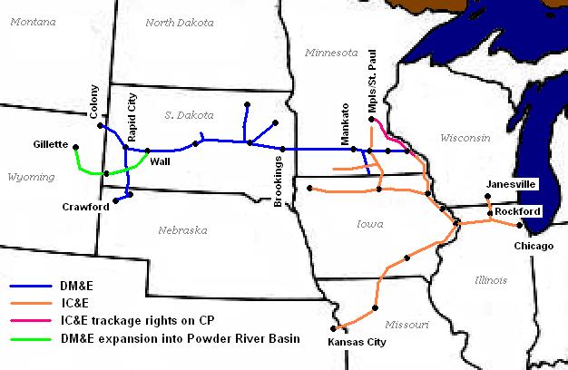
English: Route map of the Dakota and the Iowa as of 2002
State and lake outlines extracted from Perry-Castañeda Library Map Collection; the Library's FAQ asserts public domain status on the original map. Railroad outlines and city and state labels by Sean Lamb (User:Slambo), January 20 2005; created using Microsoft Paint, based on a map published in the May 2002 issue of Trains Magazine (p. 14). |
| Date | 21 January 2005 (original upload date) |
| Source | Transferred from en.wikipedia to Commons by Sreejithk2000 using CommonsHelper. |
| Author | Slambo at English Wikipedia |

|
This transport map image could be re-created using vector graphics as an SVG file. This has several advantages; see Commons:Media for cleanup for more information. If an SVG form of this image is available, please upload it and afterwards replace this template with
{{vector version available|new image name}}.
It is recommended to name the SVG file “DME and ICE route map.svg”—then the template Vector version available (or Vva) does not need the new image name parameter. |
 | This transport map image was uploaded in the JPEG format even though it consists of non-photographic data. This information could be stored more efficiently or accurately in the PNG or SVG format. If possible, please upload a PNG or SVG version of this image without compression artifacts, derived from a non-JPEG source (or with existing artifacts removed). After doing so, please tag the JPEG version with {{Superseded|NewImage.ext}} and remove this tag. This tag should not be applied to photographs or scans. If this image is a diagram or other image suitable for vectorisation, please tag this image with {{Convert to SVG}} instead of {{BadJPEG}}. If not suitable for vectorisation, use {{Convert to PNG}}. For more information, see {{BadJPEG}}. |  |
Licensing
| Public domainPublic domainfalsefalse |
| This work has been released into the public domain by its author, Slambo at English Wikipedia. This applies worldwide. In some countries this may not be legally possible; if so: Slambo grants anyone the right to use this work for any purpose, without any conditions, unless such conditions are required by law.Public domainPublic domainfalsefalse |
Original upload log
The original description page was here. All following user names refer to en.wikipedia.
- 2005-01-21 02:34 Slambo 626×408× (42355 bytes) Route map of the [[Dakota, Minnesota and Eastern Railroad]] and the [[Iowa, Chicago and Eastern Railroad]] as of [[2002]]
Captions
Add a one-line explanation of what this file represents
Items portrayed in this file
depicts
21 January 2005
image/jpeg
449ac46fd2089e13bc35f1ed060024017a5d4261
42,355 byte
408 pixel
626 pixel
File history
Click on a date/time to view the file as it appeared at that time.
| Date/Time | Thumbnail | Dimensions | User | Comment | |
|---|---|---|---|---|---|
| current | 01:46, 3 June 2010 | | 626 × 408 (41 KB) | File Upload Bot (Magnus Manske) | {{BotMoveToCommons|en.wikipedia|year={{subst:CURRENTYEAR}}|month={{subst:CURRENTMONTHNAME}}|day={{subst:CURRENTDAY}}}} {{Information |Description={{en|Route map of the en:Dakota, Minnesota and Eastern Railroad and the [[:en:Iowa, Chicago and Easter |
File usage
The following pages on the English Wikipedia use this file (pages on other projects are not listed):
Global file usage
The following other wikis use this file:
- Usage on de.wikipedia.org
Metadata
This file contains additional information, probably added from the digital camera or scanner used to create or digitize it.
If the file has been modified from its original state, some details may not fully reflect the modified file.
| _error | 0 |
|---|
Retrieved from "https://en.wikipedia.org/wiki/File:DME_and_ICE_route_map.JPG"