File:Côte_d'Ivoire_Map.jpg
From Wikipedia, the free encyclopedia
Size of this preview: 470 × 600 pixels. Other resolutions: 188 × 240 pixels | 376 × 480 pixels | 602 × 768 pixels | 1,036 × 1,322 pixels.
Original file (1,036 × 1,322 pixels, file size: 440 KB, MIME type: image/jpeg)
| This is a file from the Wikimedia Commons. Information from its description page there is shown below. Commons is a freely licensed media file repository. You can help. |
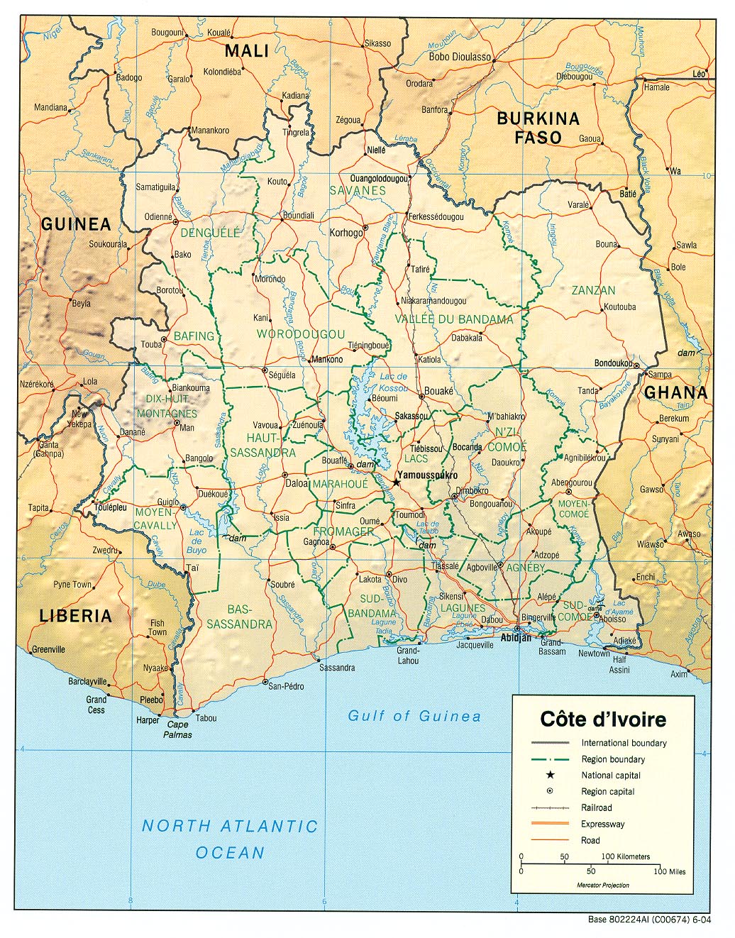
| DescriptionCôte d'Ivoire Map.jpg |
English: haded relief map of Côte d'Ivoire. |
||||
| Date | |||||
| Source | [1] from the Perry-Castañeda Library Map Collection. | ||||
| Author | CIA | ||||
| Permission (Reusing this file) |
|

Captions
Add a one-line explanation of what this file represents
Items portrayed in this file
depicts
2004
image/jpeg
bdd12cd14bfe8c74ab5de4176c238e70f9dd2c59
450,966 byte
1,322 pixel
1,036 pixel
File history
Click on a date/time to view the file as it appeared at that time.
| Date/Time | Thumbnail | Dimensions | User | Comment | |
|---|---|---|---|---|---|
| current | 11:11, 21 February 2006 | | 1,036 × 1,322 (440 KB) | Lupo | Shaded relief map of Côte d'Ivoire. Source: [http://www.lib.utexas.edu/maps/africa/cote_divoire_rel04.jpg] from the [http://www.lib.utexas.edu/maps/cote_d'ivoire.html Perry-Castañeda Library Map Collection]. {{PD-USGov-CIA}} [[Category:Maps of C� |
File usage
The following pages on the English Wikipedia use this file (pages on other projects are not listed):
Global file usage
The following other wikis use this file:
- Usage on als.wikipedia.org
- Usage on ar.wikipedia.org
- Usage on az.wikipedia.org
- Usage on bar.wikipedia.org
- Usage on be.wikipedia.org
- Usage on bn.wikipedia.org
- Usage on ca.wikipedia.org
- Usage on ckb.wikipedia.org
- Usage on cv.wikipedia.org
- Usage on de.wikipedia.org
- Usage on es.wikipedia.org
- Usage on fa.wikipedia.org
- Usage on fr.wikipedia.org
- Usage on fr.wikinews.org
- Usage on fy.wikipedia.org
- Usage on gd.wikipedia.org
- Usage on gl.wikipedia.org
- Usage on hi.wikipedia.org
- Usage on id.wikipedia.org
- Usage on it.wikipedia.org
- Usage on ka.wikipedia.org
- Usage on kbp.wikipedia.org
- Usage on kk.wikipedia.org
- Usage on lfn.wikipedia.org
- Usage on ms.wikipedia.org
- Usage on mzn.wikipedia.org
- Usage on nl.wikipedia.org
- Usage on pl.wikipedia.org
- Usage on ru.wikipedia.org
- Usage on sa.wikipedia.org
- Usage on sw.wikipedia.org
- Usage on ta.wikipedia.org
View more global usage of this file.
Metadata
This file contains additional information, probably added from the digital camera or scanner used to create or digitize it.
If the file has been modified from its original state, some details may not fully reflect the modified file.
| Orientation | Normal |
|---|---|
| Horizontal resolution | 150 dpi |
| Vertical resolution | 150 dpi |
| Software used | Adobe Photoshop 7.0 |
| File change date and time | 15:33, 27 September 2004 |
| Color space | Uncalibrated |
Retrieved from "https://en.wikipedia.org/wiki/File:Côte_d%27Ivoire_Map.jpg"