File:Czechoslovakia01.png
From Wikipedia, the free encyclopedia
Size of this preview: 800 × 340 pixels. Other resolutions: 320 × 136 pixels | 1,100 × 468 pixels.
Original file (1,100 × 468 pixels, file size: 63 KB, MIME type: image/png)
| This is a file from the Wikimedia Commons. Information from its description page there is shown below. Commons is a freely licensed media file repository. You can help. |
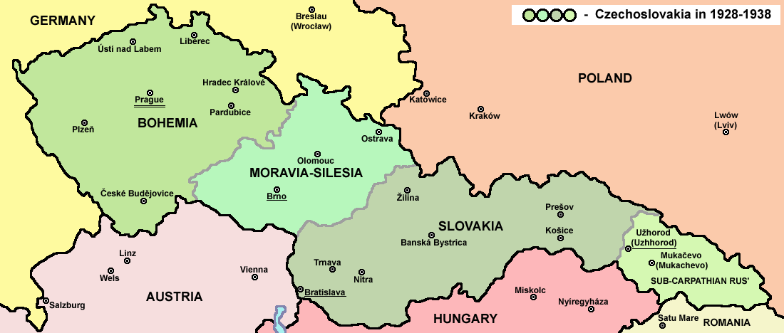
Summary
| DescriptionCzechoslovakia01.png |
English: Map of Czechoslovakia in 1928-1938. Note: The provinces shown on the map were introduced by Act No. 125/1927 Zb. and became effective in 1928. Deutsch: Karte der Tschechoslowakei zwischen 1928 und 1938. |
|||
| Date | ||||
| Source |
Own work Main reference:
Secondary references with similar maps:
Secondary references about Geo-political situation - published sources:
Secondary reference about sizable cities: |
|||
| Author |
PANONIAN
|
|||
| Permission (Reusing this file) |
|
|||
| Other versions |
Derivative works of this file: |


|
This map image could be re-created using vector graphics as an SVG file. This has several advantages; see Commons:Media for cleanup for more information. If an SVG form of this image is available, please upload it and afterwards replace this template with
{{vector version available|new image name}}.
It is recommended to name the SVG file “Czechoslovakia01.svg”—then the template Vector version available (or Vva) does not need the new image name parameter. |
The production, editing or release of this file was supported by the Community-Budget of Wikimedia Deutschland. To see other files made with the support of Wikimedia Deutschland, please see the category Supported by Wikimedia Deutschland. العربية ∙ বাংলা ∙ Deutsch ∙ English ∙ Esperanto ∙ français ∙ magyar ∙ Bahasa Indonesia ∙ italiano ∙ 日本語 ∙ македонски ∙ മലയാളം ∙ Bahasa Melayu ∙ Nederlands ∙ português ∙ русский ∙ slovenščina ∙ svenska ∙ українська ∙ +/−
|
Captions
Add a one-line explanation of what this file represents
Items portrayed in this file
depicts
some value
2006
image/png
bd003d1960e9404724758c8fa7f85ee852d01738
64,020 byte
468 pixel
1,100 pixel
File history
Click on a date/time to view the file as it appeared at that time.
| Date/Time | Thumbnail | Dimensions | User | Comment | |
|---|---|---|---|---|---|
| current | 14:48, 12 July 2022 | | 1,100 × 468 (63 KB) | Sebastian Wallroth | cropped |
| 10:54, 19 May 2011 |  | 1,128 × 513 (63 KB) | PANONIAN | minor change, marked provincial capitals | |
| 09:53, 17 May 2011 |  | 1,128 × 513 (62 KB) | PANONIAN | Reverted to version as of 10:38, 24 April 2011 - because this is map of Czechoslovakia and it was capital of Czechoslovakia | |
| 05:07, 17 May 2011 |  | 1,128 × 513 (55 KB) | Millenium187 | Why was Prague underlined and Vienna, Brno, Bratislava and other capital cities were not? -- corrected | |
| 10:38, 24 April 2011 |  | 1,128 × 513 (62 KB) | PANONIAN | few corrections | |
| 11:31, 23 April 2011 |  | 1,128 × 509 (61 KB) | PANONIAN | improved version | |
| 20:58, 20 December 2008 |  | 1,100 × 497 (78 KB) | Kirk979 | {{Information |Description= |Source= |Date= |Author= |Permission= |other_versions= }} | |
| 16:11, 28 December 2006 |  | 1,100 × 497 (90 KB) | Electionworld | {{ew|en|PANONIAN}} Map of {{link|Czechoslovakia}} (self made) Note: The provinces shown on the map were introduced by Act No. 125/1927 Zb. and became effective in 1928. {{PD-self}} Category:Maps of Czechoslovakia Category:Maps of Czech history |
File usage
The following pages on the English Wikipedia use this file (pages on other projects are not listed):
- Bohemia
- Czechoslovak myth
- Czechoslovakia
- Development of the administrative divisions of Ukraine
- Economy of communist Czechoslovakia
- Eparchy of Mukačevo and Prešov
- Fall Grün (Czechoslovakia)
- Formation of the Eastern Bloc
- History of Czechoslovakia (1918–1938)
- History of Slovakia
- History of the Czech lands
- May Crisis
- Orthodox Church of the Czech Lands and Slovakia
- Tanks of Czechoslovakia
- Talk:Lizabeth Scott
- User:Vltava/sandbox/images
- Wikipedia talk:WikiProject Maps/Archive 5
- Portal:Czech Republic
- Portal:Slovakia
Global file usage
The following other wikis use this file:
- Usage on af.wikipedia.org
- Usage on als.wikipedia.org
- Usage on ang.wikipedia.org
- Usage on an.wikipedia.org
- Usage on ar.wikipedia.org
- Usage on arz.wikipedia.org
- Usage on azb.wikipedia.org
- Usage on az.wikipedia.org
- Usage on bar.wikipedia.org
- Usage on ba.wikipedia.org
- Usage on bcl.wikipedia.org
- Usage on be-tarask.wikipedia.org
- Usage on be.wikipedia.org
- Usage on bg.wikipedia.org
- Usage on bn.wikipedia.org
- Usage on br.wikipedia.org
- Usage on ca.wikipedia.org
- Usage on cs.wikipedia.org
- Usage on cv.wikipedia.org
- Usage on cy.wikipedia.org
- Usage on de.wikipedia.org
- Usage on diq.wikipedia.org
- Usage on dsb.wikipedia.org
- Usage on el.wikipedia.org
- Usage on en.wiktionary.org
- Usage on eo.wikipedia.org
View more global usage of this file.
Metadata
This file contains additional information, probably added from the digital camera or scanner used to create or digitize it.
If the file has been modified from its original state, some details may not fully reflect the modified file.
| Horizontal resolution | 28.35 dpc |
|---|---|
| Vertical resolution | 28.35 dpc |
Retrieved from "https://en.wikipedia.org/wiki/File:Czechoslovakia01.png"