File:Cricklade,_High_Street_-_geograph.org.uk_-_268609.jpg
From Wikipedia, the free encyclopedia
No higher resolution available.
Cricklade,_High_Street_-_geograph.org.uk_-_268609.jpg (640 × 480 pixels, file size: 118 KB, MIME type: image/jpeg)
| This is a file from the Wikimedia Commons. Information from its description page there is shown below. Commons is a freely licensed media file repository. You can help. |
Summary
| DescriptionCricklade, High Street - geograph.org.uk - 268609.jpg |
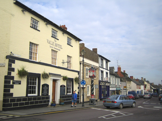
English: Cricklade: High Street This view was taken looking north along the High Street at its junction with the B4040 Calcutt Street. The Vale Hotel was originally the White Horse Inn, and there is a small but fine clock tower at the junction. |
| Date | |
| Source | From geograph.org.uk |
| Author | Nigel Cox |
| Attribution (required by the license) InfoField | Nigel Cox / Cricklade: High Street / |
InfoField | Nigel Cox / Cricklade: High Street |
| Object location | 51° 38′ 30″ N, 1° 51′ 22″ W | View this and other nearby images on: OpenStreetMap |
|---|
Licensing

|
This image was taken from the Geograph project collection. See this photograph's page on the Geograph website for the photographer's contact details. The copyright on this image is owned by Nigel Cox and is licensed for reuse under the Creative Commons Attribution-ShareAlike 2.0 license.
|
This file is licensed under the Creative Commons Attribution-Share Alike 2.0 Generic license.
Attribution: Nigel Cox
- You are free:
- to share – to copy, distribute and transmit the work
- to remix – to adapt the work
- Under the following conditions:
- attribution – You must give appropriate credit, provide a link to the license, and indicate if changes were made. You may do so in any reasonable manner, but not in any way that suggests the licensor endorses you or your use.
- share alike – If you remix, transform, or build upon the material, you must distribute your contributions under the same or compatible license as the original.
Captions
Add a one-line explanation of what this file represents
Items portrayed in this file
depicts
some value
24 October 2006
51°38'29.8"N, 1°51'21.6"W
image/jpeg
ff5641891f47673752b155e3553b9f991ee865c0
120,775 byte
480 pixel
640 pixel
File history
Click on a date/time to view the file as it appeared at that time.
| Date/Time | Thumbnail | Dimensions | User | Comment | |
|---|---|---|---|---|---|
| current | 15:25, 12 December 2010 | | 640 × 480 (118 KB) | GeographBot | == {{int:filedesc}} == {{Information |description={{en|1=Cricklade: High Street This view was taken looking north along the High Street at its junction with the B4040 Calcutt Street. The Vale Hotel was originally the White Horse Inn, and there is a small |
File usage
The following pages on the English Wikipedia use this file (pages on other projects are not listed):
Global file usage
The following other wikis use this file:
- Usage on azb.wikipedia.org
- Usage on ceb.wikipedia.org
- Usage on cy.wikipedia.org
- Usage on en.wikivoyage.org
- Usage on es.wikipedia.org
- Usage on fa.wikipedia.org
- Usage on ga.wikipedia.org
- Usage on id.wikipedia.org
- Usage on it.wikipedia.org
- Usage on lld.wikipedia.org
- Usage on mt.wikipedia.org
- Usage on ru.wikipedia.org
- Usage on sv.wikipedia.org
- Usage on uk.wikipedia.org
- Usage on www.wikidata.org
- Usage on zh-min-nan.wikipedia.org
- Usage on zh.wikipedia.org
Metadata
This file contains additional information, probably added from the digital camera or scanner used to create or digitize it.
If the file has been modified from its original state, some details may not fully reflect the modified file.
| _error | 0 |
|---|