File:Cottus_gobio_(in_situ).jpg
From Wikipedia, the free encyclopedia
Size of this preview: 800 × 600 pixels. Other resolutions: 320 × 240 pixels | 640 × 480 pixels | 1,024 × 768 pixels | 1,280 × 960 pixels | 2,400 × 1,800 pixels.
Original file (2,400 × 1,800 pixels, file size: 4.04 MB, MIME type: image/jpeg)
| This is a file from the Wikimedia Commons. Information from its description page there is shown below. Commons is a freely licensed media file repository. You can help. |
The factual accuracy of this description or the file name is disputed.
Reason: Please see the relevant discussion on the talk page. |
.jpg)
| Camera location | 50° 04′ 35.6″ N, 4° 34′ 48.1″ E | View this and other nearby images on: OpenStreetMap |
|---|
| Photographer |
Hans Hillewaert |
| Description |
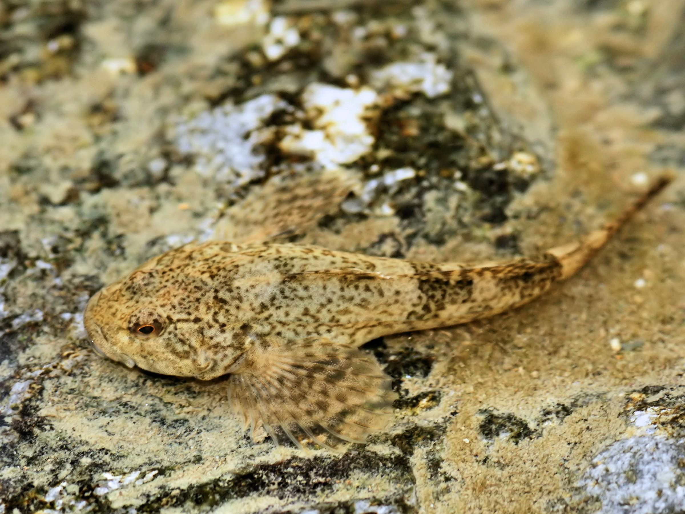
Cottus gobio Linnaeus, 1758 Deutsch: Groppe
English: European bullhead in the Viroin close to Nismes.
Français : Chabot commun. Photo prise dans le Viroin, près de Nismes.
Nederlands: Cottus gobio
Polski: Głowacz białopłetwy |
| Date | 1 June 2009 |
| Source | Own work |
| Permission (Reusing this file) |
This file is licensed under the Creative Commons Attribution-Share Alike 4.0 International license. Attribution: © Hans Hillewaert
|
| Other licenses InfoField | More (4100+) and new images on : High resolution files on request. . |
| Attribution (required by the license) InfoField | © Hans Hillewaert / |
InfoField | © Hans Hillewaert |

|
This image has been assessed under the valued image criteria and is considered the most valued image on Commons within the scope: Cottus gobio (European bullhead). You can see its nomination here. |
.jpg)
Captions
Add a one-line explanation of what this file represents
Items portrayed in this file
depicts
50°4'35.60002"N, 4°34'48.10001"E
50°4'35.60002"N, 4°34'48.10001"E
0.008 second
0.008 second
5.6
5.6
105 millimetre
105 millimetre
800
800
image/jpeg
217638933e1dbd8cae6f945e56332b48e60cb4d3
4,234,805 byte
1,800 pixel
2,400 pixel
File history
Click on a date/time to view the file as it appeared at that time.
| Date/Time | Thumbnail | Dimensions | User | Comment | |
|---|---|---|---|---|---|
| current | 07:11, 28 June 2011 | | 2,400 × 1,800 (4.04 MB) | Biopics | levels & wb |
| 07:35, 5 June 2009 |  | 2,400 × 1,800 (1,013 KB) | Lycaon | {{Location|50|4|35.60|N|4|34|48.10|E}} {{Information |Description= ''Cottus gobio'' Linnaeus, 1758 {{en|European bullhead in the Eau Noire close to Nismes}} |Source= {{own}} |Date= 2009-06-01 |Author= Hans Hillewaert |Permission= {{se |
File usage
The following pages on the English Wikipedia use this file (pages on other projects are not listed):
Global file usage
The following other wikis use this file:
- Usage on als.wikipedia.org
- Usage on ar.wikipedia.org
- Usage on arz.wikipedia.org
- Usage on ba.wikipedia.org
- Usage on be.wikipedia.org
- Usage on bg.wikipedia.org
- Usage on ca.wikipedia.org
- Usage on ceb.wikipedia.org
- Usage on cs.wikipedia.org
- Usage on cy.wikipedia.org
- Usage on de.wikipedia.org
- Rheingroppe
- Böhmerwald und Mühltäler (Europaschutzgebiet)
- Bodenseeuferlandschaft östlich Friedrichshafen
- Untere Argen und Seitentäler
- Rotachtal Bodensee
- Bodenseeufer westlich Friedrichshafen
- Bodensee Hinterland bei Überlingen
- Überlinger See und Bodenseeuferlandschaft
- Cottus
- Zwettltal
- Donau zwischen Riedlingen und Sigmaringen
- Obere Argen und Seitentäler
- Wurzacher Ried und Rohrsee
- Nördliche Baaralb und Donau bei Immendingen
- Riede und Gewässer bei Mengen und Pfullendorf
- Gebiete um das Laucherttal
- Oberes Donautal zwischen Beuron und Sigmaringen
- Schmeietal
- Liste von Fischen und Rundmäulern in Nordrhein-Westfalen
- Neckar und Seitentäler bei Rottenburg
- Gebiete zwischen Bisingen, Haigerloch und Rosenfeld
- Rot, Bellamonter Rottum und Dürnach
- Umlachtal und Riß südlich Biberach
- Donau zwischen Munderkingen und Ulm und nördliche Iller
- Aitrach, Ach und Dürrenbach
- Donau zwischen Munderkingen und Riedlingen
- Großer Heuberg und Donautal
- Östlicher Großer Heuberg
- Spitzberg, Pfaffenberg, Kochhartgraben und Neckar
View more global usage of this file.
.jpg)
Metadata
This file contains additional information, probably added from the digital camera or scanner used to create or digitize it.
If the file has been modified from its original state, some details may not fully reflect the modified file.
| Image title | SONY DSC |
|---|---|
| Camera manufacturer | SONY |
| Camera model | DSLR-A700 |
| Author | Hans Hillewaert |
| Exposure time | 1/125 sec (0.008) |
| F-number | f/5.6 |
| ISO speed rating | 800 |
| Date and time of data generation | 18:42, 1 June 2009 |
| Lens focal length | 105 mm |
| Copyright holder | © Hans Hillewaert |
| Source | own |
| Credit/Provider | © Hans Hillewaert cc-by-sa-3.0 |
| Orientation | Normal |
| Horizontal resolution | 72 dpi |
| Vertical resolution | 72 dpi |
| Software used | PaintShop Photo Pro 13.00 |
| File change date and time | 09:11, 28 June 2011 |
| Y and C positioning | Co-sited |
| Exposure Program | Normal program |
| Exif version | 2.21 |
| Date and time of digitizing | 18:42, 1 June 2009 |
| Meaning of each component |
|
| Image compression mode | 8 |
| APEX brightness | 4 |
| Exposure bias | 0 |
| Maximum land aperture | 3 APEX (f/2.83) |
| Metering mode | Spot |
| Light source | Shade |
| Flash | Flash fired, compulsory flash firing |
| DateTime subseconds | 0 |
| DateTimeOriginal subseconds | 0 |
| DateTimeDigitized subseconds | 0 |
| Supported Flashpix version | 1 |
| Color space | sRGB |
| File source | Digital still camera |
| Scene type | A directly photographed image |
| Custom image processing | Normal process |
| Exposure mode | Auto exposure |
| White balance | Manual white balance |
| Digital zoom ratio | 0 |
| Focal length in 35 mm film | 157 mm |
| Scene capture type | Standard |
| Contrast | Normal |
| Saturation | Normal |
| Sharpness | Normal |
| IIM version | 2 |
Retrieved from "https://en.wikipedia.org/wiki/File:Cottus_gobio_(in_situ).jpg"
.jpg)