File:Cook_Islands_(New_Zealand)_map.png
From Wikipedia, the free encyclopedia
Cook_Islands_(New_Zealand)_map.png (324 × 348 pixels, file size: 15 KB, MIME type: image/png)
| This is a file from the Wikimedia Commons. Information from its description page there is shown below. Commons is a freely licensed media file repository. You can help. |
Summary
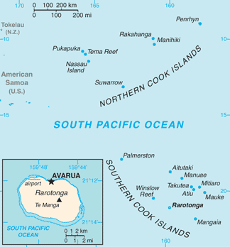
| DescriptionCook Islands (New Zealand) map.png |
English: Map of Cook Islands (New Zealand)
Italiano: Mappa delle Isole Cook (Nuova Zelanda) |
||||
| Date | |||||
| Source | https://www.cia.gov/library/publications/the-world-factbook/geos/cw.html | ||||
| Author | Directorate of Intelligence, CIA | ||||
| Permission (Reusing this file) |
|
Licensing
| Public domainPublic domainfalsefalse |
This image is in the public domain because it contains materials that originally came from the United States Central Intelligence Agency's World Factbook.
Bahasa Indonesia ∙ čeština ∙ Deutsch ∙ eesti ∙ English ∙ español ∙ Esperanto ∙ français ∙ galego ∙ hrvatski ∙ italiano ∙ Nederlands ∙ norsk nynorsk ∙ polski ∙ português ∙ sicilianu ∙ slovenščina ∙ suomi ∙ Türkçe ∙ Zazaki ∙ беларуская (тарашкевіца) ∙ македонски ∙ русский ∙ српски / srpski ∙ українська ∙ ქართული ∙ বাংলা ∙ தமிழ் ∙ മലയാളം ∙ 한국어 ∙ 日本語 ∙ 中文 ∙ 中文(简体) ∙ 中文(繁體) ∙ العربية ∙ +/− |
 |
Original upload log
| Date/Time | Dimensions | User | Comment |
|---|---|---|---|
| 16 March 2013, 18:45:06 | 328 × 353 (19796 bytes) | Edoardo Cavaleri (talk · contribs) | {{Information |Description ={{en|1=Map of Cook Islands (New Zealand)}} {{it|1=Mappa delle Isole Cook (Nuova Zelanda)}} |Source =https://www.cia.gov/library/publications/the-world-factbook/geos/cw.html |Author =Directorate of Intellig... |
Captions
Items portrayed in this file
depicts
16 March 2013
image/png
c7b2719d30673e17b2055db3a71ac8a309352080
14,930 byte
348 pixel
324 pixel
File history
Click on a date/time to view the file as it appeared at that time.
| Date/Time | Thumbnail | Dimensions | User | Comment | |
|---|---|---|---|---|---|
| current | 05:16, 13 February 2022 | | 324 × 348 (15 KB) | Lojwe | Cropped 1 % horizontally, 1 % vertically using CropTool with precise mode. |
| 11:38, 25 November 2014 |  | 328 × 353 (19 KB) | GifTagger | Bot: Converting file to superior PNG file. (Source: Cook_Islands_(New_Zealand)_map.gif). This GIF was problematic due to non-greyscale color table. |
_map.gif)
File usage
Global file usage
The following other wikis use this file:
- Usage on ar.wikipedia.org
- Usage on ast.wikipedia.org
- Usage on ca.wikipedia.org
- Usage on co.wikipedia.org
- Usage on de.wikipedia.org
- Usage on el.wikipedia.org
- Usage on es.wikipedia.org
- Usage on eu.wikipedia.org
- Usage on fr.wikipedia.org
- Usage on gl.wikipedia.org
- Usage on hif.wikipedia.org
- Usage on incubator.wikimedia.org
- Usage on io.wikipedia.org
- Usage on it.wikipedia.org
- Usage on ja.wikipedia.org
- Usage on mt.wikipedia.org
- Usage on pt.wikipedia.org
- Usage on ro.wikipedia.org
- Usage on ru.wikipedia.org
- Usage on sr.wikipedia.org
- Usage on test.wikidata.org
- Usage on tg.wikipedia.org
- Usage on th.wikipedia.org
- Usage on tl.wikipedia.org
- Usage on uk.wikipedia.org
- Usage on www.wikidata.org
- Usage on zh.wikipedia.org
Metadata
This file contains additional information, probably added from the digital camera or scanner used to create or digitize it.
If the file has been modified from its original state, some details may not fully reflect the modified file.
| File change date and time | 05:16, 13 February 2022 |
|---|
_map.png)