File:Chicago_L_diagram_sb.svg
From Wikipedia, the free encyclopedia

Size of this PNG preview of this SVG file: 535 × 600 pixels. Other resolutions: 214 × 240 pixels | 428 × 480 pixels | 685 × 768 pixels | 913 × 1,024 pixels | 1,827 × 2,048 pixels | 1,650 × 1,850 pixels.
Original file (SVG file, nominally 1,650 × 1,850 pixels, file size: 48 KB)
| This is a file from the Wikimedia Commons. Information from its description page there is shown below. Commons is a freely licensed media file repository. You can help. |
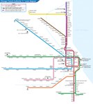
| DescriptionChicago L diagram sb.svg |
English: Map of the Chicago 'L'. |
|||
| Date | 24 January 2016, 06:33:50 (upload date) | |||
| Source | Own work | |||
| Author | Sameboat | |||
| Permission (Reusing this file) |
I, the copyright holder of this work, hereby publish it under the following license: This file is licensed under the Creative Commons Attribution-Share Alike 4.0 International license.
|
|||
| Other versions |
|

This vector image was created with a text editor.
Please do not replace the simplified code of this file with a version created with Inkscape or any other vector graphics editor

|
This file is saved in human-editable plain text format. Any editing of the image or creation of any derivative work should be performed using a text editor. Please do not upload edits saved or exported with Inkscape or similar vector graphics editors, as well as with automated tools such as SVG Translate. |
Captions
Add a one-line explanation of what this file represents
Items portrayed in this file
depicts
24 January 2016
image/svg+xml
778c9f6f92611683f6e13417e69e9a3e94df9c06
49,054 byte
1,850 pixel
1,650 pixel
File history
Click on a date/time to view the file as it appeared at that time.
| Date/Time | Thumbnail | Dimensions | User | Comment | |
|---|---|---|---|---|---|
| current | 05:36, 23 January 2023 | | 1,650 × 1,850 (48 KB) | Sameboat | Add Purple Express stop at Wilson station |
| 00:13, 7 January 2021 |  | 1,650 × 1,850 (48 KB) | Sameboat | fix blur line station icons | |
| 02:36, 30 December 2020 |  | 1,650 × 1,850 (48 KB) | Sameboat | wrap all <defs> instances in <g id="xxx"> | |
| 14:54, 15 July 2018 |  | 1,650 × 1,850 (48 KB) | Sameboat | doctype | |
| 02:40, 4 September 2017 |  | 1,650 × 1,850 (48 KB) | Sameboat | Purple rush in legend | |
| 01:42, 4 September 2017 |  | 1,650 × 1,850 (48 KB) | Sameboat | minor fix of the blur filter | |
| 14:26, 1 September 2017 |  | 1,650 × 1,850 (48 KB) | Sameboat | ||
| 08:22, 1 September 2017 |  | 1,650 × 1,850 (46 KB) | Sameboat | Randolph/Wabash -> Washington/Wabash; style change of single-way loop entrance indication | |
| 02:24, 8 August 2017 |  | 1,650 × 1,850 (45 KB) | Sameboat | Planned Damen station (Green line) and few minor adjustments. | |
| 02:28, 4 March 2016 |  | 1,650 × 1,850 (44 KB) | Sameboat | + river |
File usage
The following pages on the English Wikipedia use this file (pages on other projects are not listed):
Global file usage
The following other wikis use this file:
- Usage on bn.wikipedia.org
- Usage on cy.wikipedia.org
- Usage on de.wikipedia.org
- Usage on en.wikivoyage.org
- Usage on eo.wikipedia.org
- Usage on es.wikipedia.org
- Usage on fa.wikipedia.org
- Usage on fi.wikipedia.org
- Usage on fr.wikipedia.org
- Usage on he.wikipedia.org
- Usage on he.wikivoyage.org
- Usage on hu.wikipedia.org
- Usage on id.wikipedia.org
- Usage on it.wikipedia.org
- Usage on ja.wikipedia.org
- Usage on ko.wikipedia.org
- Usage on pl.wikipedia.org
- Usage on ru.wikipedia.org
- Usage on simple.wikipedia.org
- Usage on sr.wikipedia.org
- Usage on th.wikipedia.org
- Usage on tr.wikipedia.org
- Usage on uk.wikipedia.org
- Usage on www.wikidata.org
- Usage on zh.wikipedia.org
Metadata
This file contains additional information, probably added from the digital camera or scanner used to create or digitize it.
If the file has been modified from its original state, some details may not fully reflect the modified file.
| Short title | Chicago Transit Authority "L" diagram licensed under the Creative Commons Attribution-Share Alike 4.0 International by Wikimedia(s). |
|---|---|
| Width | 1650 |
| Height | 1850 |
Retrieved from "https://en.wikipedia.org/wiki/File:Chicago_L_diagram_sb.svg"