File:Carte_Skagerrak-Kattegat2.png
From Wikipedia, the free encyclopedia
No higher resolution available.
Carte_Skagerrak-Kattegat2.png (445 × 508 pixels, file size: 15 KB, MIME type: image/png)
| This is a file from the Wikimedia Commons. Information from its description page there is shown below. Commons is a freely licensed media file repository. You can help. |
Summary
| DescriptionCarte Skagerrak-Kattegat2.png |
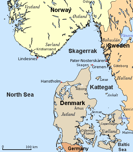
English: Map of Skagerrak and Kattegat — straits/bays of the North Sea, along Denmark, Norway, and Sweden.
Dansk: Kort over Skagerrak og Kattegat (Danmark, Norge, Sverige).
Deutsch: Karte von Skagerrak und Kattegat (Dänemark, Norwegen, Schweden).
Français : Carte du Skagerrak et du Kattegat (Danemark, Norvège, Suède).
|
| Date | 8 December 2006 (original upload date) |
| Source |
English: Modification of
Dansk: Bearbejdelse af
Deutsch: Bearbeitung von
File:Carte_Skagerrak-Kattegat.png |
| Author | The original uploader was Attilios at English Wikipedia. |
| Other versions |
|


Licensing
| This file is licensed under the Creative Commons Attribution-Share Alike 3.0 Unported license. Subject to disclaimers. | ||
| ||
| This licensing tag was added to this file as part of the GFDL licensing update.http://creativecommons.org/licenses/by-sa/3.0/CC BY-SA 3.0Creative Commons Attribution-Share Alike 3.0truetrue |

|
Permission is granted to copy, distribute and/or modify this document under the terms of the GNU Free Documentation License, Version 1.2 or any later version published by the Free Software Foundation; with no Invariant Sections, no Front-Cover Texts, and no Back-Cover Texts. A copy of the license is included in the section entitled GNU Free Documentation License. Subject to disclaimers.http://www.gnu.org/copyleft/fdl.htmlGFDLGNU Free Documentation Licensetruetrue |
Original upload log
Transferred from en.wikipedia to Commons by Smooth_O using CommonsHelper.
The original description page was here. All following user names refer to en.wikipedia.
- 2006-12-08 19:07 Attilios 445×508×4 (15028 bytes) Modification of Carte_Skagerrak-Kattegat.png {{GFDL}}
Captions
Map showing Skaggerrak & Kattegat sea areas between Norway and Sweden
تنگه اسکاگراک
Items portrayed in this file
depicts
8 December 2006
image/png
f3f019b7c77593470ca78c5866155e128bcc7f15
15,194 byte
508 pixel
445 pixel
File history
Click on a date/time to view the file as it appeared at that time.
| Date/Time | Thumbnail | Dimensions | User | Comment | |
|---|---|---|---|---|---|
| current | 18:50, 6 March 2018 | | 445 × 508 (15 KB) | Hohum | Cartographic colours, nations. |
| 13:51, 15 June 2008 |  | 445 × 508 (15 KB) | File Upload Bot (Magnus Manske) | {{BotMoveToCommons|en.wikipedia}} {{Information |Description={{en|Modification of Carte_Skagerrak-Kattegat.png}} |Source=Transferred from [http://en.wikipedia.org en.wikipedia]; transfered to Commons by User:Smooth_O using [http://tools.wikimedia.de/ |
File usage
The following pages on the English Wikipedia use this file (pages on other projects are not listed):
Global file usage
The following other wikis use this file:
- Usage on ar.wikipedia.org
- Usage on ast.wikipedia.org
- Usage on azb.wikipedia.org
- Usage on bn.wikipedia.org
- Usage on bs.wikipedia.org
- Usage on ca.wikipedia.org
- Usage on diq.wikipedia.org
- Usage on el.wikipedia.org
- Usage on es.wikipedia.org
- Usage on eu.wikipedia.org
- Usage on fa.wikipedia.org
- Usage on ga.wikipedia.org
- Usage on gl.wikipedia.org
- Usage on he.wikipedia.org
- Usage on hr.wikipedia.org
- Usage on it.wikipedia.org
- Usage on ja.wikipedia.org
- Usage on ka.wikipedia.org
- Usage on ko.wikipedia.org
- Usage on ku.wikipedia.org
- Usage on la.wikipedia.org
- Usage on lt.wikipedia.org
- Usage on lv.wikipedia.org
- Usage on ps.wikipedia.org
- Usage on ro.wikipedia.org
- Usage on rue.wikipedia.org
- Usage on sco.wikipedia.org
- Usage on sh.wikipedia.org
- Usage on sl.wikipedia.org
- Usage on sr.wikipedia.org
- Usage on ta.wikipedia.org
- Usage on th.wikipedia.org
View more global usage of this file.
Metadata
This file contains additional information, probably added from the digital camera or scanner used to create or digitize it.
If the file has been modified from its original state, some details may not fully reflect the modified file.
| Horizontal resolution | 28.35 dpc |
|---|---|
| Vertical resolution | 28.35 dpc |
| File change date and time | 18:49, 6 March 2018 |
Retrieved from "https://en.wikipedia.org/wiki/File:Carte_Skagerrak-Kattegat2.png"