File:California_rivers.jpg
From Wikipedia, the free encyclopedia
Size of this preview: 497 × 599 pixels. Other resolutions: 199 × 240 pixels | 398 × 480 pixels | 637 × 768 pixels | 849 × 1,024 pixels | 2,506 × 3,022 pixels.
Original file (2,506 × 3,022 pixels, file size: 1.6 MB, MIME type: image/jpeg)
| This is a file from the Wikimedia Commons. Information from its description page there is shown below. Commons is a freely licensed media file repository. You can help. |
Summary
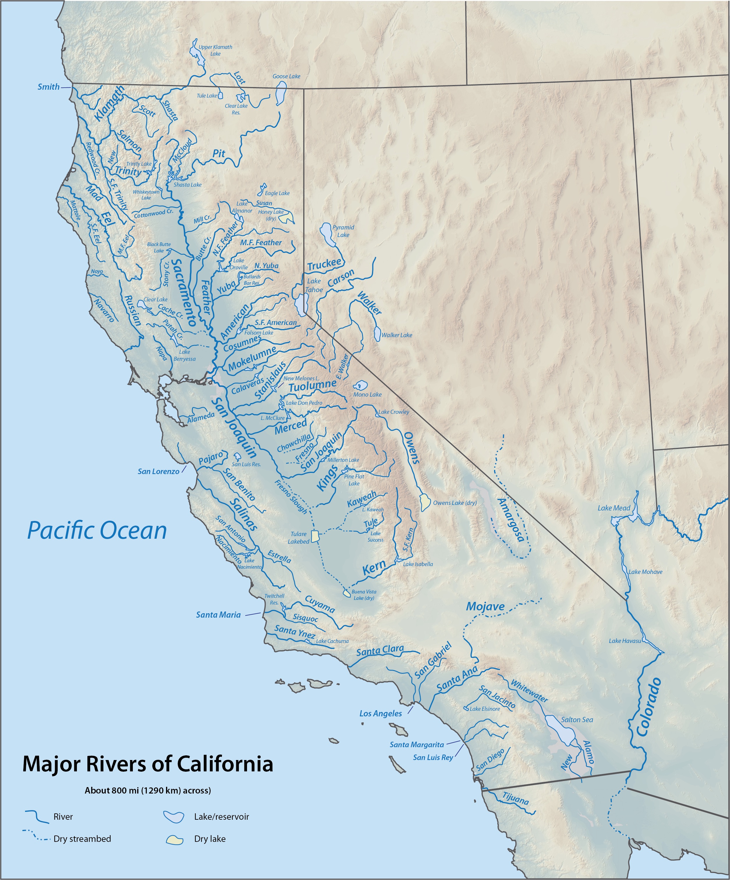
| DescriptionCalifornia rivers.jpg |
English: Map of major rivers in California based on DEMIS Mapserver shaded relief |
| Date | updated 19:57, 6 September 2010 (UTC) |
| Source | Derived from DEMIS map sections copied and assembled together |
| Author | Me |
Licensing
| Public domainPublic domainfalsefalse |
This image is in the public domain in the United States because it only contains materials that originally came from the United States Geological Survey, an agency of the United States Department of the Interior. For more information, see the official USGS copyright policy.
Bahasa Indonesia ∙ català ∙ čeština ∙ Deutsch ∙ eesti ∙ English ∙ español ∙ français ∙ galego ∙ italiano ∙ Nederlands ∙ português ∙ polski ∙ sicilianu ∙ suomi ∙ Tiếng Việt ∙ Türkçe ∙ български ∙ македонски ∙ русский ∙ മലയാളം ∙ 한국어 ∙ 日本語 ∙ 中文 ∙ 中文(简体) ∙ 中文(繁體) ∙ العربية ∙ فارسی ∙ +/− |
Original upload log
The original description page was here. All following user names refer to en.wikipedia.
- 2010-09-06 03:59 Shannon1 1084×1176× (952304 bytes) forgot to draw a section of the North Feather
- 2010-09-06 03:55 Shannon1 1084×1176× (952303 bytes) change terrain to Demis (also PD), add a few more rivers, fixed some names (possibly)?
- 2010-01-12 03:41 Shannon1 (usurped3) 752×854× (377169 bytes) HOW COULD I HAVE FORGOTTEN TO LABEL THE SACRAMENTO RIVER?!
- 2010-01-12 03:38 Shannon1 (usurped3) 752×854× (373336 bytes) {{Information |Description = Map of major rivers in California based on USGS shaded relief |Source = http://birrell.org/andrew/reliefMaps/, which is derived from USGS DEM (Digital Elevation Module) files assembled together |Date =
Captions
Add a one-line explanation of what this file represents
Items portrayed in this file
depicts
image/jpeg
b38706700a100a806838fa1e29949cd942a899fd
1,676,516 byte
3,022 pixel
2,506 pixel
File history
Click on a date/time to view the file as it appeared at that time.
| Date/Time | Thumbnail | Dimensions | User | Comment | |
|---|---|---|---|---|---|
| current | 17:11, 18 October 2015 | | 2,506 × 3,022 (1.6 MB) | Shannon1 | changed to higher resolution USGS relief and added a few rivers/lakes, fixed a few labels |
| 01:33, 19 September 2013 |  | 1,084 × 1,176 (930 KB) | OgreBot | (BOT): Reverting to most recent version before archival | |
| 01:33, 19 September 2013 |  | 1,084 × 1,176 (930 KB) | OgreBot | (BOT): Uploading old version of file from en.wikipedia; originally uploaded on 2010-09-06 03:55:05 by Shannon1 | |
| 01:33, 19 September 2013 |  | 752 × 854 (368 KB) | OgreBot | (BOT): Uploading old version of file from en.wikipedia; originally uploaded on 2010-01-12 03:41:42 by Shannon1 (usurped3) | |
| 01:33, 19 September 2013 |  | 752 × 854 (365 KB) | OgreBot | (BOT): Uploading old version of file from en.wikipedia; originally uploaded on 2010-01-12 03:38:50 by Shannon1 (usurped3) | |
| 15:38, 19 October 2012 |  | 1,084 × 1,176 (930 KB) | Urdangaray | {{Information |Description={{en|Map of major rivers in California based on DEMIS Mapserver shaded relief}} |Source=Transferred from [http://en.wikipedia.org en.wikipedia]<br/> (Original text : ''Derived from DEMIS map sections copied and assembled toge... |
File usage
The following pages on the English Wikipedia use this file (pages on other projects are not listed):
Global file usage
The following other wikis use this file:
- Usage on bg.wikipedia.org
- Usage on ca.wikipedia.org
- Usage on es.wikipedia.org
- Usage on fi.wikipedia.org
- Usage on nl.wikipedia.org
Metadata
This file contains additional information, probably added from the digital camera or scanner used to create or digitize it.
If the file has been modified from its original state, some details may not fully reflect the modified file.
| Orientation | Normal |
|---|---|
| Horizontal resolution | 72 dpi |
| Vertical resolution | 72 dpi |
| Software used | Adobe ImageReady |
| Color space | sRGB |
Retrieved from "https://en.wikipedia.org/wiki/File:California_rivers.jpg"