File:Calais_-_Manifestation_contre_les_clandestins,_l'immigration-invasion_et_l'islamisation_de_l'Europe,_8_novembre_2015_(22).JPG
From Wikipedia, the free encyclopedia
Size of this preview: 800 × 555 pixels. Other resolutions: 320 × 222 pixels | 640 × 444 pixels | 1,024 × 710 pixels | 1,280 × 887 pixels | 2,560 × 1,775 pixels | 5,184 × 3,594 pixels.
Original file (5,184 × 3,594 pixels, file size: 6.21 MB, MIME type: image/jpeg)
| This is a file from the Wikimedia Commons. Information from its description page there is shown below. Commons is a freely licensed media file repository. You can help. |
Summary
| DescriptionCalais - Manifestation contre les clandestins, l'immigration-invasion et l'islamisation de l'Europe, 8 novembre 2015 (22).JPG |
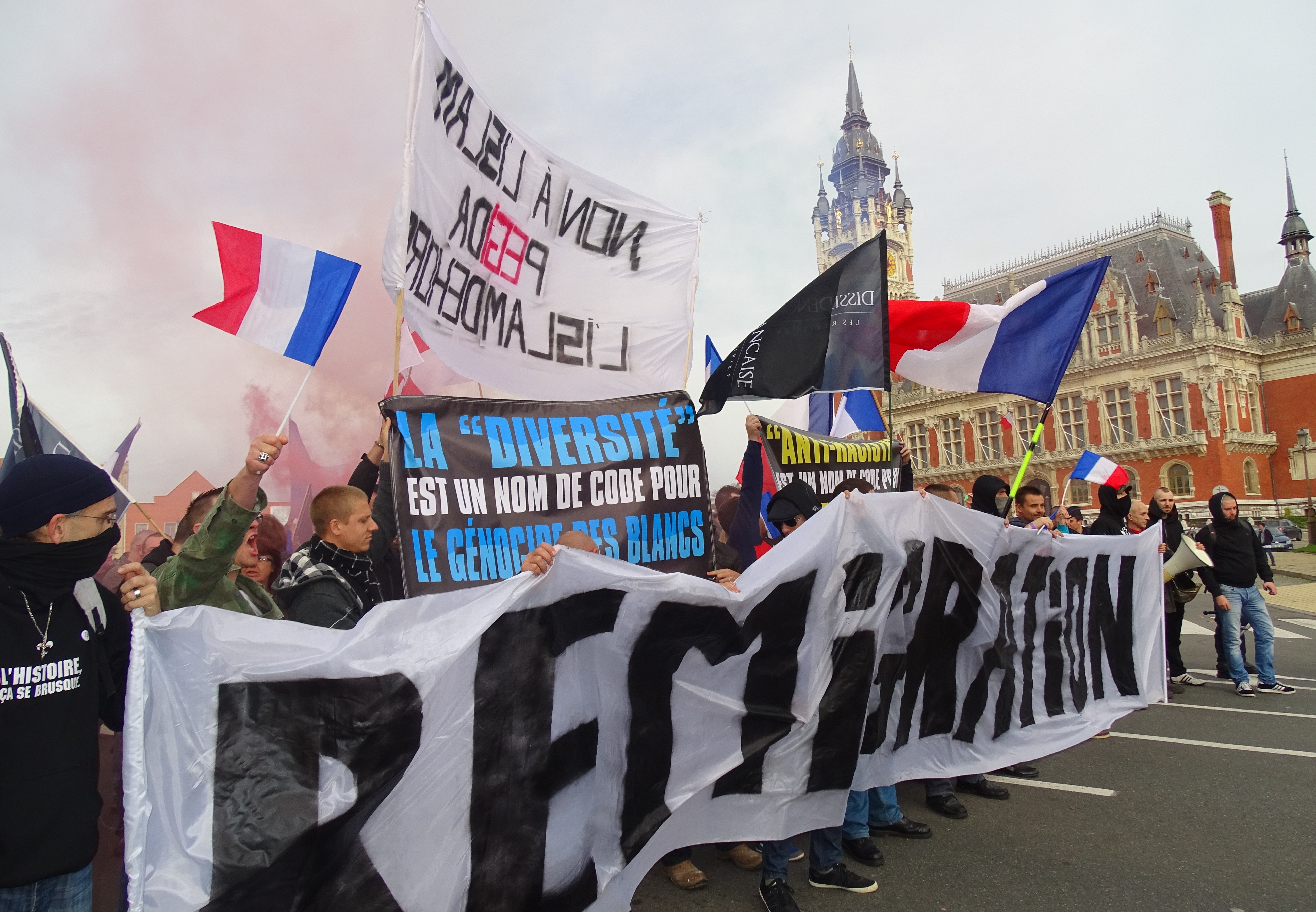
English: Demonstration against illegal immigrants, immigration-invasion and the Islamization of Europe on November 8, 2015 in Calais, Nord, Nord-Pas-de-Calais, France. A few hours later, during the night, sixteen police officers working for the security of Calaisians were injured in the Jungle, the slum of illegal immigrants. New violence took place the next day and the day after Français : Autres éléments du BMNPC Manifestation contre les clandestins, l'immigration-invasion et l'islamisation de l'Europe le 8 novembre 2015 à Calais |
|||||||||||||||||||||||
| Date | ||||||||||||||||||||||||
| Source | Own work | |||||||||||||||||||||||
| Author |
creator QS:P170,Q58229383 |
|||||||||||||||||||||||
| Permission (Reusing this file) |
| |||||||||||||||||||||||
| Attribution (required by the license) InfoField | Jérémy-Günther-Heinz Jähnick / Calais - Manifestation contre les clandestins, l'immigration-invasion et l'islamisation de l'Europe, 8 novembre 2015 (22) / Wikimedia Commons / | |||||||||||||||||||||||
InfoField | Jérémy-Günther-Heinz Jähnick / Calais - Manifestation contre les clandestins, l'immigration-invasion et l'islamisation de l'Europe, 8 novembre 2015 (22) / Wikimedia Commons | |||||||||||||||||||||||
.JPG)

| Camera location | 50° 57′ 06.49″ N, 1° 51′ 12.17″ E | View this and other nearby images on: OpenStreetMap |
|---|
Captions
Add a one-line explanation of what this file represents
Items portrayed in this file
depicts
8 November 2015
50°57'6.4910002"N, 1°51'12.1730000"E
0.00125 second
3.2
4.3 millimetre
image/jpeg
7cdaa7361de12aca907075cbdad7e1f5dde50c16
6,510,477 byte
3,594 pixel
5,184 pixel
File history
Click on a date/time to view the file as it appeared at that time.
| Date/Time | Thumbnail | Dimensions | User | Comment | |
|---|---|---|---|---|---|
| current | 10:57, 9 November 2015 | | 5,184 × 3,594 (6.21 MB) | Jérémy-Günther-Heinz Jähnick |
File usage
The following pages on the English Wikipedia use this file (pages on other projects are not listed):
Global file usage
The following other wikis use this file:
- Usage on ar.wikipedia.org
- Usage on es.wikipedia.org
- Usage on fa.wikipedia.org
- Usage on fr.wikipedia.org
- Usage on fr.wiktionary.org
- Usage on he.wikipedia.org
- Usage on hy.wikipedia.org
- Usage on id.wikipedia.org
- Usage on it.wikipedia.org
- Usage on it.wikiquote.org
- Usage on ko.wikipedia.org
- Usage on ms.wikipedia.org
- Usage on nl.wikipedia.org
- Usage on pt.wikipedia.org
- Usage on ro.wikipedia.org
- Usage on ru.wikipedia.org
- Usage on sr.wikipedia.org
- Usage on sv.wikipedia.org
- Usage on zh.wikipedia.org
Metadata
This file contains additional information, probably added from the digital camera or scanner used to create or digitize it.
If the file has been modified from its original state, some details may not fully reflect the modified file.
| Camera manufacturer | SONY |
|---|---|
| Camera model | DSC-HX400V |
| Exposure time | 1/800 sec (0.00125) |
| F-number | f/3.2 |
| ISO speed rating | 80 |
| Date and time of data generation | 12:53, 8 November 2015 |
| Lens focal length | 4.3 mm |
| Latitude | 50° 57′ 6.49″ N |
| Longitude | 1° 51′ 12.17″ E |
| Altitude | 11.7 meters below sea level |
| Orientation | Normal |
| Horizontal resolution | 350 dpi |
| Vertical resolution | 350 dpi |
| Software used | DSC-HX400V v2.00 |
| File change date and time | 10:50, 9 November 2015 |
| Y and C positioning | Co-sited |
| Exposure Program | Normal program |
| Exif version | 2.3 |
| Date and time of digitizing | 12:53, 8 November 2015 |
| Meaning of each component |
|
| Image compression mode | 2 |
| APEX brightness | 9.52109375 |
| Exposure bias | 0 |
| Maximum land aperture | 2.96875 APEX (f/2.8) |
| Metering mode | Pattern |
| Light source | Unknown |
| Flash | Flash fired, strobe return light not detected, compulsory flash firing |
| Supported Flashpix version | 1 |
| Color space | sRGB |
| File source | Digital still camera |
| Scene type | A directly photographed image |
| Custom image processing | Normal process |
| Exposure mode | Auto exposure |
| White balance | Auto white balance |
| Digital zoom ratio | 1 |
| Scene capture type | Standard |
| Contrast | Normal |
| Saturation | Normal |
| Sharpness | Normal |
| Unique image ID | BB7FFE21DCE747248F96272EF6FEDF92 |
| GPS time (atomic clock) | 11:53 |
| Receiver status | Measurement in progress |
| Measurement mode | 3-dimensional measurement |
| Measurement precision | Poor (1.36) |
| Speed unit | Kilometers per hour |
| Speed of GPS receiver | 0.31 |
| Reference for direction of movement | True direction |
| Direction of movement | 110.16 |
| Geodetic survey data used | WGS-84 |
| GPS date | 8 November 2015 |
| GPS differential correction | 0 |
| GPS tag version | 2.3.0.0 |
.JPG)