File:CEM-36-NE-corner.jpg
From Wikipedia, the free encyclopedia
Size of this preview: 800 × 600 pixels. Other resolutions: 320 × 240 pixels | 640 × 480 pixels | 1,024 × 768 pixels | 1,280 × 960 pixels | 2,560 × 1,920 pixels.
Original file (2,560 × 1,920 pixels, file size: 2.02 MB, MIME type: image/jpeg)
| This is a file from the Wikimedia Commons. Information from its description page there is shown below. Commons is a freely licensed media file repository. You can help. |
Summary
| DescriptionCEM-36-NE-corner.jpg |
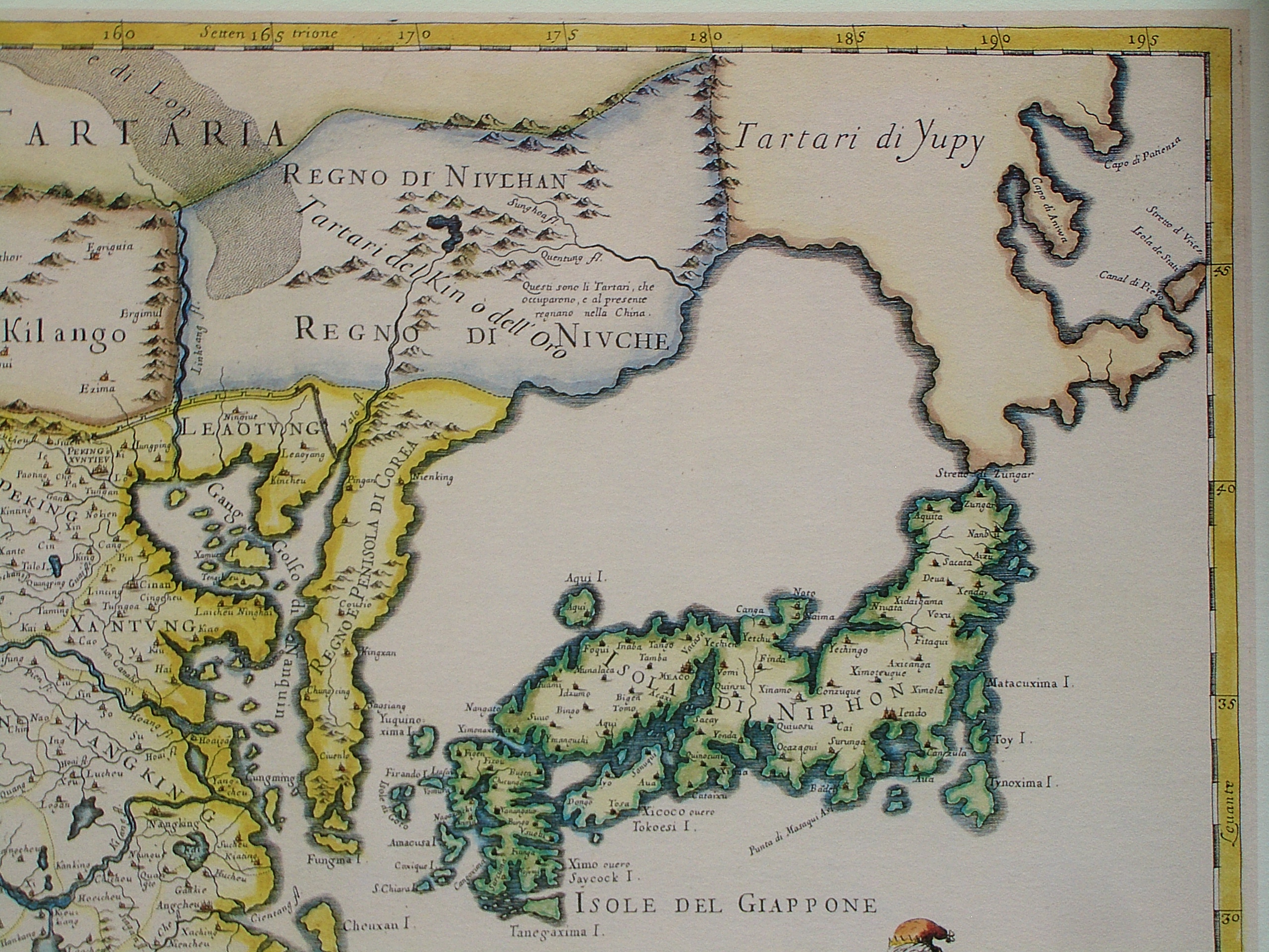
English: The north-eastern corner of a map of China (in Italian): "The Kingdom of China, presently called Catay and Mangin, divided into its principal provinces on a most precise map". This part shows includes Sea of Japan and Japan itself. However, neither the La Pérouse Strait nor the Strait of Tartary were known to the cartographer, and therefore Hokkaido and Sakhalin are all part of the mainland, populated by the "Yupi Tartars" (i.e. the "Fishskin Tartars" - the old Chinese name for the Nanai people and related groups). However, the eastern coast of Sakhalin, with Cape Aniwa and Cape Patience are already charted more or less correctly (thanks to a Dutch expedition in the 1640s). Sakhalin and Hokkaido are both represented as one peninsula in Yupi Tartars, and are separated from Japan by "Stretto di Züngar" (today Tsugaru Strait), between today Hokkaido and Honshu (Isola di Niphon). Probably in reference of the city of "Züngar" (today Tsugaru) shown in north of Honshu.
Italiano: "Il regno della China detto presentemente Catay e Mangin diuiso sopra le carte piu esatte nelle sue principali prouincie" |
||||||
| Date | Originally published 1682; the copy at HKUST is a 1689 reprint. | ||||||
| Source |
English: An antique map from the Special Collection "China in Maps" of the Hong Kong University of Science and Technology Library, reproduced by the HKUST Library in the book "China in European Maps", Hong Kong, 2003. ISBN 962-86403-9-9.
Русский: Старинная карта из специальной коллекции Библиотеки Гонконгского научно-технического университета. Опубликована этой библиотекой в книге "China in European Maps" (Китай на европейских картах), Гонконг, 2003. ISBN 962-86403-9-9, тиражом 1000 экз. См. также каталог выставки, Special Collection "China in Maps".
Plate 36: "Il regno della China detto presentemente Catay e Mangin diuiso sopra le carte piu esatte nelle sue principali prouincie" |
||||||
| Author | Giacomo Cantelli da Vignola (1643-1695), Giovanni Giacomo de Rossi (1627-1691) | ||||||
| Permission (Reusing this file) |
|
||||||
| Other versions |
Entire map:  |
||||||
| Annotations InfoField | This image is annotated: View the annotations at Commons |
147
762
560
192
2560
1920
Willow palisade
Captions
Add a one-line explanation of what this file represents
Items portrayed in this file
depicts
image/jpeg
2f9794ab254848c048b59f077ad1f0ee45ac1153
2,115,252 byte
1,920 pixel
2,560 pixel
File history
Click on a date/time to view the file as it appeared at that time.
| Date/Time | Thumbnail | Dimensions | User | Comment | |
|---|---|---|---|---|---|
| current | 12:52, 19 March 2009 | | 2,560 × 1,920 (2.02 MB) | Vmenkov | {{Information |Description={{en|1=The north-eastern cornet of a map of China (in Italian): "The Kingdom of China, presently called Catay and Mangin, divided into its principal provinces on a most precise map". This part shows includes Sea of Japan and Ja |
File usage
The following pages on the English Wikipedia use this file (pages on other projects are not listed):
Global file usage
The following other wikis use this file:
- Usage on af.wikipedia.org
- Usage on ar.wikipedia.org
- Usage on ast.wikipedia.org
- Usage on bg.wikipedia.org
- Usage on bn.wikipedia.org
- Usage on cs.wikipedia.org
- Usage on es.wikipedia.org
- Usage on es.wikivoyage.org
- Usage on fr.wikipedia.org
- Usage on fy.wikipedia.org
- Usage on it.wikipedia.org
- Usage on ja.wikipedia.org
- Usage on my.wikipedia.org
- Usage on nl.wikipedia.org
- Usage on ru.wikipedia.org
- Usage on tr.wikipedia.org
- Usage on vi.wikipedia.org
Metadata
This file contains additional information, probably added from the digital camera or scanner used to create or digitize it.
If the file has been modified from its original state, some details may not fully reflect the modified file.
| Camera manufacturer | CASIO COMPUTER CO.,LTD |
|---|---|
| Camera model | EX-Z50 |
| Exposure time | 1/400 sec (0.0025) |
| F-number | f/6.2 |
| Date and time of data generation | 15:44, 19 March 2009 |
| Lens focal length | 12.2 mm |
| Orientation | Normal |
| Horizontal resolution | 72 dpi |
| Vertical resolution | 72 dpi |
| Software used | 0.90 |
| File change date and time | 15:44, 19 March 2009 |
| Y and C positioning | Centered |
| Exposure Program | Normal program |
| Exif version | 2.21 |
| Date and time of digitizing | 15:44, 19 March 2009 |
| Image compression mode | 3.6666666666667 |
| Exposure bias | 1 |
| Maximum land aperture | 2.8 APEX (f/2.64) |
| Metering mode | Center weighted average |
| Light source | Unknown |
| Flash | Flash did not fire, compulsory flash suppression |
| Color space | sRGB |
| Custom image processing | Normal process |
| Exposure mode | Manual exposure |
| White balance | Auto white balance |
| Focal length in 35 mm film | 74 mm |
| Scene capture type | Standard |
| Contrast | Hard |
| Saturation | Normal |
| Sharpness | Hard |
Retrieved from "https://en.wikipedia.org/wiki/File:CEM-36-NE-corner.jpg"