File:Burundi_sat.png
From Wikipedia, the free encyclopedia
No higher resolution available.
Burundi_sat.png (223 × 259 pixels, file size: 86 KB, MIME type: image/png)
| This is a file from the Wikimedia Commons. Information from its description page there is shown below. Commons is a freely licensed media file repository. You can help. |
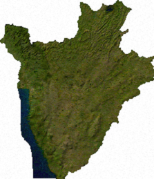
ECW to TIFF to PNG (compression level 9).
| Public domainPublic domainfalsefalse |
| This file is in the public domain, because it was generated by a user, using free sources available at The Map Library.
Note that this does not include the maps in the Global Administrative Areas section of the homepage. |
Captions
Add a one-line explanation of what this file represents
Items portrayed in this file
depicts
image/png
aab643bd869066499b096df538738536ccbad6cb
87,873 byte
259 pixel
223 pixel
File history
Click on a date/time to view the file as it appeared at that time.
| Date/Time | Thumbnail | Dimensions | User | Comment | |
|---|---|---|---|---|---|
| current | 02:58, 13 July 2006 | | 223 × 259 (86 KB) | Unquietwiki | ECW to TIFF to PNG (compression level 9). {{PD-MapLibrary}} |
File usage
The following pages on the English Wikipedia use this file (pages on other projects are not listed):
Global file usage
The following other wikis use this file:
- Usage on ba.wikipedia.org
- Usage on be.wikipedia.org
- Usage on bn.wikipedia.org
- Usage on fa.wikipedia.org
- Usage on ja.wikipedia.org
- Usage on ka.wikipedia.org
- Usage on ru.wikipedia.org
- Usage on uk.wikipedia.org
- Usage on uz.wikipedia.org
- Usage on vi.wikipedia.org
- Usage on xmf.wikipedia.org
Retrieved from "https://en.wikipedia.org/wiki/File:Burundi_sat.png"