File:Bouvet_Map.png
From Wikipedia, the free encyclopedia
Size of this preview: 787 × 600 pixels. Other resolutions: 315 × 240 pixels | 630 × 480 pixels | 1,008 × 768 pixels | 1,280 × 975 pixels | 2,560 × 1,950 pixels | 2,804 × 2,136 pixels.
Original file (2,804 × 2,136 pixels, file size: 876 KB, MIME type: image/png)
| This is a file from the Wikimedia Commons. Information from its description page there is shown below. Commons is a freely licensed media file repository. You can help. |
| DescriptionBouvet Map.png |
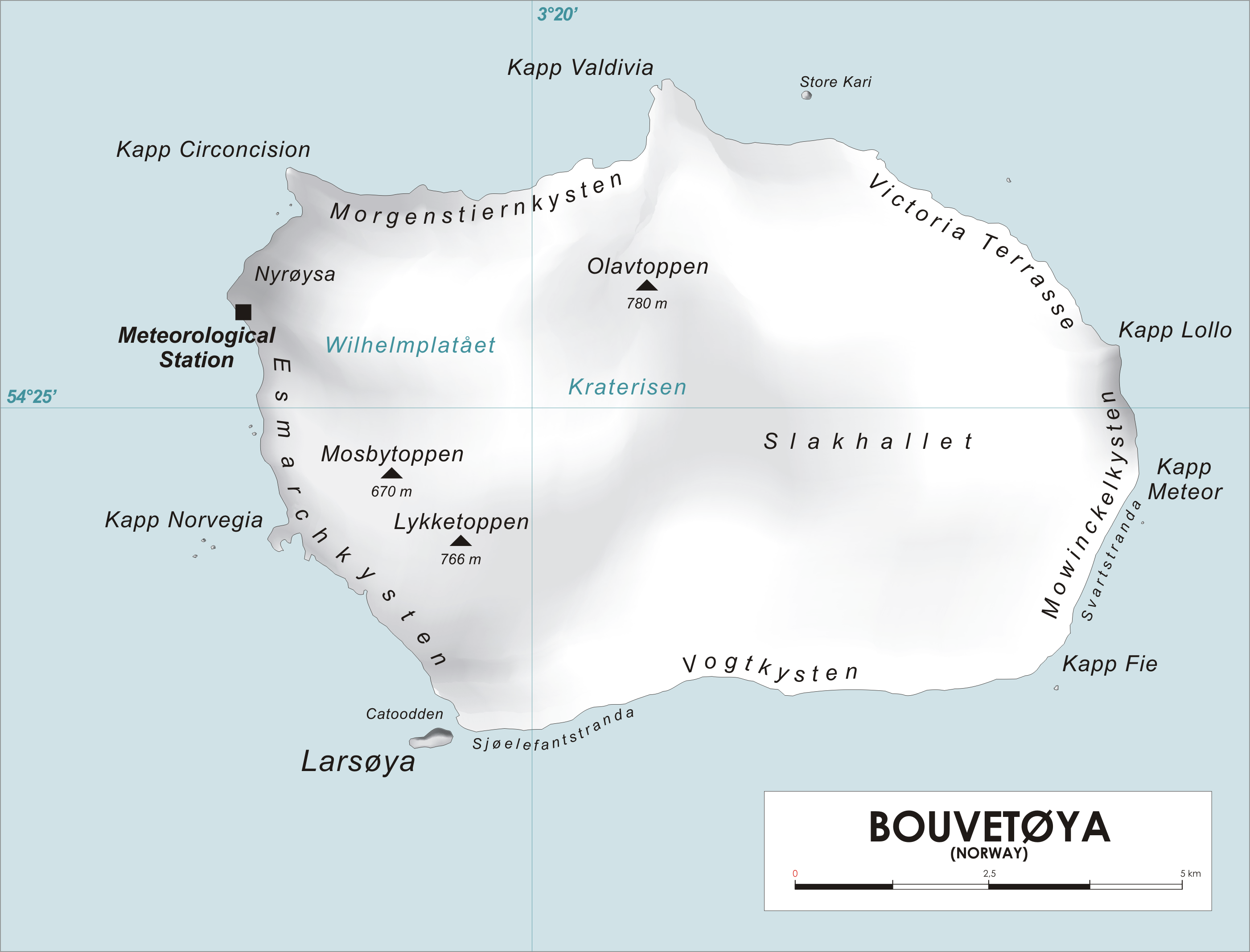
English: Map of Bouvet Island, Southern Atlantic Ocean Norsk bokmål: Kart over Bouvetøya, Sør-Atlanten |
| Source | Own work |
| Author | varp |
| Public domainPublic domainfalsefalse |
| I, the copyright holder of this work, release this work into the public domain. This applies worldwide. In some countries this may not be legally possible; if so: I grant anyone the right to use this work for any purpose, without any conditions, unless such conditions are required by law. |
Captions
Add a one-line explanation of what this file represents
Items portrayed in this file
depicts
image/png
ed55cb03dc2c5a2e040e8a73c680c0b716e88d26
897,339 byte
2,136 pixel
2,804 pixel
File history
Click on a date/time to view the file as it appeared at that time.
| Date/Time | Thumbnail | Dimensions | User | Comment | |
|---|---|---|---|---|---|
| current | 12:25, 28 April 2006 | | 2,804 × 2,136 (876 KB) | Varp~commonswiki | *Map of Bouvet Island, Southern Atlantic Ocean *drawn by varp |
File usage
The following pages on the English Wikipedia use this file (pages on other projects are not listed):
- Benn Skerries
- Bolle Bay
- Cape Circoncision
- Cape Fie
- Cape Lollo
- Cape Meteor
- Cape Valdivia
- Cato Point
- Larsøya
- Lille Kari Rock
- Lindsay Reef
- List of glaciers of Bouvet Island
- Lykketoppen
- Morrell Reef
- Mosbytoppane
- Mowinckelkysten
- Norris Reef
- Norvegia Point
- Norvegia Rock
- Olavtoppen
- Rustad Knoll
- Sachse Rocks
- Spiess Rocks
- Williams Reef
Global file usage
The following other wikis use this file:
- Usage on als.wikipedia.org
- Usage on ar.wikipedia.org
- Usage on arz.wikipedia.org
- Usage on ba.wikipedia.org
- Usage on ca.wikipedia.org
- Usage on ceb.wikipedia.org
- Usage on cs.wikipedia.org
- Usage on cy.wikipedia.org
- Usage on da.wikipedia.org
- Usage on de.wikipedia.org
- Usage on de.wikivoyage.org
- Usage on el.wikipedia.org
- Usage on es.wikipedia.org
- Usage on eu.wikipedia.org
- Usage on fi.wikipedia.org
- Usage on frr.wikipedia.org
- Usage on fr.wikipedia.org
- Usage on fy.wikipedia.org
- Usage on gl.wikipedia.org
View more global usage of this file.
Retrieved from "https://en.wikipedia.org/wiki/File:Bouvet_Map.png"