File:BloodyMarshMap.jpg
From Wikipedia, the free encyclopedia
Size of this preview: 800 × 557 pixels. Other resolutions: 320 × 223 pixels | 640 × 446 pixels | 1,024 × 713 pixels | 1,280 × 891 pixels | 2,566 × 1,787 pixels.
Original file (2,566 × 1,787 pixels, file size: 3.18 MB, MIME type: image/jpeg)
| This is a file from the Wikimedia Commons. Information from its description page there is shown below. Commons is a freely licensed media file repository. You can help. |
Summary
| DescriptionBloodyMarshMap.jpg |
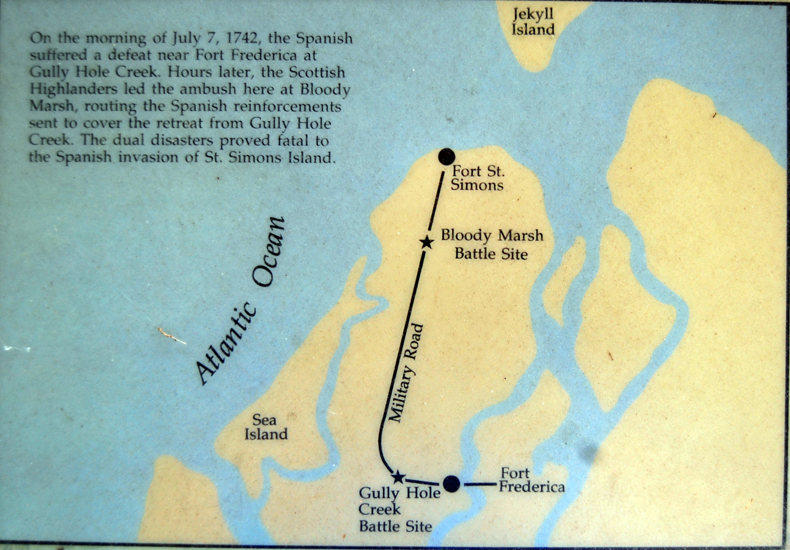
English: Map at Bloody Marsh, on en:St. Simons, Georgia. South is at the top and North is at the bottom. Transcription: "On the morning of July 7, 1742, the Spanish suffered a defeat near Fort Frederica at Gully Hole Creek. Hours later, the Scottish Highlanders led the ambush here at Bloody Marsh, routing the Spanish reinforcements sent to cover the retreat from Gully Hole Creek. The dual disasters proved fatal to the Spanish invasion of St. Simons Island." |
| Date | |
| Source | Transferred from en.wikipedia to Commons. |
| Author |
Bubba73 at English Wikipedia |
Licensing
| Public domainPublic domainfalsefalse |
This work is in the public domain in the United States because it is a work prepared by an officer or employee of the United States Government as part of that person’s official duties under the terms of Title 17, Chapter 1, Section 105 of the US Code.
Note: This only applies to original works of the Federal Government and not to the work of any individual U.S. state, territory, commonwealth, county, municipality, or any other subdivision. This template also does not apply to postage stamp designs published by the United States Postal Service since 1978. (See § 313.6(C)(1) of Compendium of U.S. Copyright Office Practices). It also does not apply to certain US coins; see The US Mint Terms of Use.
|
 | |
| This file has been identified as being free of known restrictions under copyright law, including all related and neighboring rights. | ||
https://creativecommons.org/publicdomain/mark/1.0/PDMCreative Commons Public Domain Mark 1.0falsefalse
Bubba73 at English Wikipedia, the copyright holder of this work, hereby publishes it under the following licenses:
This file is licensed under the Creative Commons Attribution-Share Alike 3.0 Unported license.
Attribution: Bubba73 at English Wikipedia
- You are free:
- to share – to copy, distribute and transmit the work
- to remix – to adapt the work
- Under the following conditions:
- attribution – You must give appropriate credit, provide a link to the license, and indicate if changes were made. You may do so in any reasonable manner, but not in any way that suggests the licensor endorses you or your use.
- share alike – If you remix, transform, or build upon the material, you must distribute your contributions under the same or compatible license as the original.

|
Permission is granted to copy, distribute and/or modify this document under the terms of the GNU Free Documentation License, Version 1.2 or any later version published by the Free Software Foundation; with no Invariant Sections, no Front-Cover Texts, and no Back-Cover Texts. A copy of the license is included in the section entitled GNU Free Documentation License.http://www.gnu.org/copyleft/fdl.htmlGFDLGNU Free Documentation Licensetruetrue |
You may select the license of your choice.
Original upload log
The original description page was here. All following user names refer to en.wikipedia.
- 2008-04-28 17:02 Bubba73 2566×1787×8 (3331437 bytes)
- 2008-04-27 00:18 Bubba73 2566×1787×8 (2105660 bytes) {{Information |Description=Map at Bloody Marsh |Source=self-made |Date=April 26, 2008 |Author=~~~ Jud McCranie |other_versions= }}
Captions
Add a one-line explanation of what this file represents
Items portrayed in this file
depicts
26 April 2008
image/jpeg
56776520b4739be6dddba6e881b3bc79e03612ae
3,331,437 byte
1,787 pixel
2,566 pixel
0.01666666666666666666 second
4.2
26 millimetre
400
File history
Click on a date/time to view the file as it appeared at that time.
| Date/Time | Thumbnail | Dimensions | User | Comment | |
|---|---|---|---|---|---|
| current | 21:29, 10 May 2008 | | 2,566 × 1,787 (3.18 MB) | File Upload Bot (Magnus Manske) | {{BotMoveToCommons|en.wikipedia}} {{Information |Description={{en|Map at Bloody Marsh, on en:St. Simons, Georgia. South is at the top and North is at the bottom.}} |Source=Transferred from [http://en.wikipedia.org en.wikipedia]; Transfer was stated |
File usage
The following pages on the English Wikipedia use this file (pages on other projects are not listed):
Global file usage
The following other wikis use this file:
- Usage on es.wikipedia.org
- Usage on fr.wikipedia.org
- Usage on ja.wikipedia.org
- Usage on ru.wikipedia.org
- Usage on www.wikidata.org
Metadata
This file contains additional information, probably added from the digital camera or scanner used to create or digitize it.
If the file has been modified from its original state, some details may not fully reflect the modified file.
| Camera manufacturer | NIKON CORPORATION |
|---|---|
| Camera model | NIKON D40 |
| Exposure time | 1/60 sec (0.016666666666667) |
| F-number | f/4.2 |
| ISO speed rating | 400 |
| Date and time of data generation | 16:48, 26 April 2008 |
| Lens focal length | 26 mm |
| Orientation | Normal |
| Horizontal resolution | 300 dpi |
| Vertical resolution | 300 dpi |
| Software used | Adobe Photoshop Elements 6.0 Windows |
| File change date and time | 13:00, 28 April 2008 |
| Y and C positioning | Co-sited |
| Exposure Program | Normal program |
| Exif version | 2.21 |
| Date and time of digitizing | 16:48, 26 April 2008 |
| Image compression mode | 4 |
| Exposure bias | 0 |
| Maximum land aperture | 4 APEX (f/4) |
| Metering mode | Pattern |
| Light source | Unknown |
| Flash | Flash did not fire |
| DateTime subseconds | 50 |
| DateTimeOriginal subseconds | 50 |
| DateTimeDigitized subseconds | 50 |
| Color space | sRGB |
| Sensing method | One-chip color area sensor |
| Custom image processing | Normal process |
| Exposure mode | Auto exposure |
| White balance | Auto white balance |
| Digital zoom ratio | 1 |
| Focal length in 35 mm film | 39 mm |
| Scene capture type | Standard |
| Contrast | Hard |
| Saturation | High saturation |
| Sharpness | Normal |
| Subject distance range | Unknown |
Retrieved from "https://en.wikipedia.org/wiki/File:BloodyMarshMap.jpg"