File:Batz-ChickasawVillages1736_SEM236C_F329014.jpg
From Wikipedia, the free encyclopedia
Original file (2,679 × 3,920 pixels, file size: 1.09 MB, MIME type: image/jpeg)
| This is a file from the Wikimedia Commons. Information from its description page there is shown below. Commons is a freely licensed media file repository. You can help. |
Summary
| DescriptionBatz-ChickasawVillages1736 SEM236C F329014.jpg |
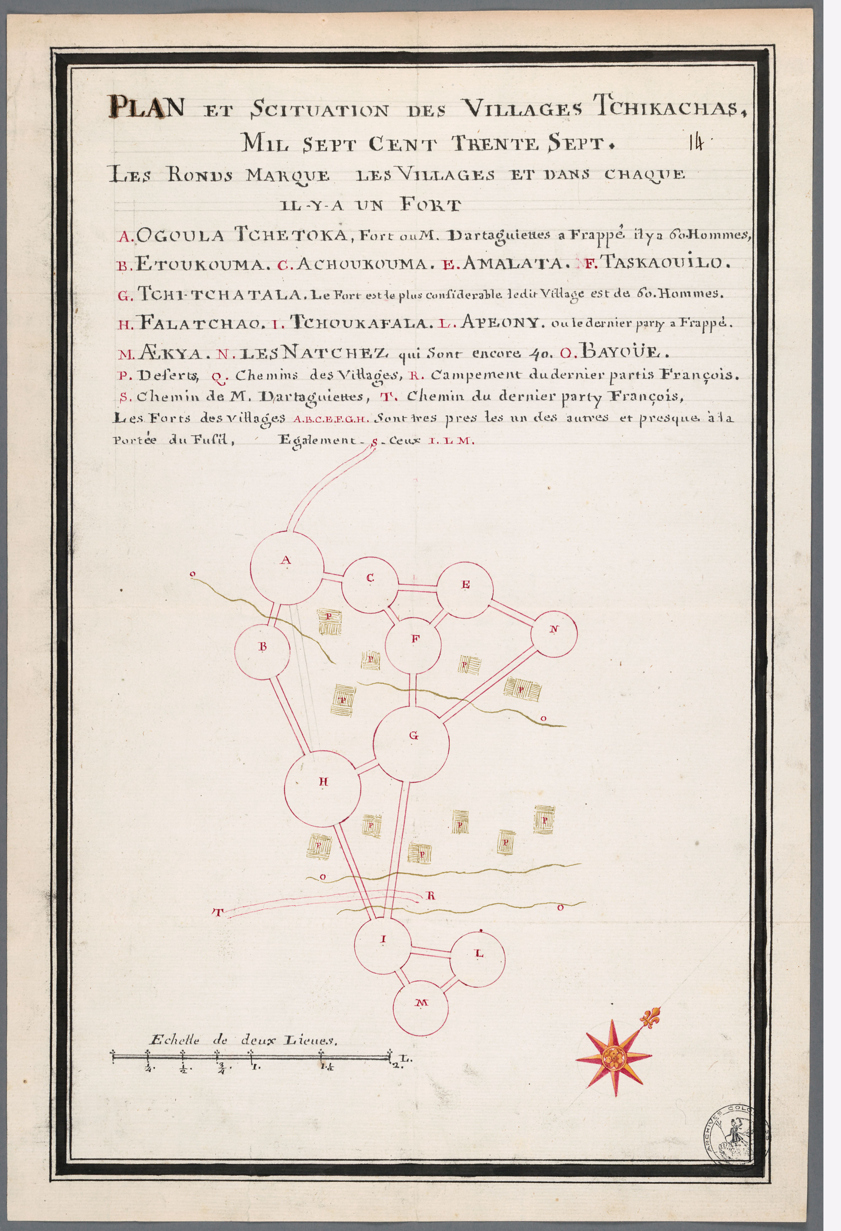
English: Plan et Scituation des Villages Tchikachas Plan and Situation of the Chickasaw Villages, Alexandre de Batz, 1737. French copy of a map made by a visitor to the Chickasaw. A indicates 'Ogoula Tchetoka, fort where M. d'Artaguette attacked', 4 mi SSE of present day Pontotoc, Mississippi on 25 March, 1736. M indicates Ackia, at present day Tupelo, Mississippi, Bienville's point of attack on May 26, 1736. |
||||||||||||||||||||||
| Date | |||||||||||||||||||||||
| Source |
Free use and distribution according to the archival description. http://bd.archivescanadafrance.org/acf/view.xsp?qid=sdx_q0&p=1&b=acfdb&id=FRCAOM_F3290_14 This map is described by Gregory A. Waselkov in Indian Maps of the Southeast, which is published in Powhatan's Mantle: Indians in the Colonial Southeast, ISBN 08032986 pp. 483-486 |
||||||||||||||||||||||
| Author |
creator QS:P170,Q18507731 |
||||||||||||||||||||||
| Permission (Reusing this file) |
This image is in the public domain due to its age. | ||||||||||||||||||||||
Licensing
| Public domainPublic domainfalsefalse |
|
This work is in the public domain in its country of origin and other countries and areas where the copyright term is the author's life plus 100 years or fewer. | |
| This file has been identified as being free of known restrictions under copyright law, including all related and neighboring rights. | |
https://creativecommons.org/publicdomain/mark/1.0/PDMCreative Commons Public Domain Mark 1.0falsefalse
Captions
Items portrayed in this file
depicts
1736
image/jpeg
66f00f57a4a21fbe9c84ccee43529db28ab003e3
1,147,716 byte
3,920 pixel
2,679 pixel
File history
Click on a date/time to view the file as it appeared at that time.
| Date/Time | Thumbnail | Dimensions | User | Comment | |
|---|---|---|---|---|---|
| current | 10:04, 16 May 2010 | | 2,679 × 3,920 (1.09 MB) | File Upload Bot (Magnus Manske) | {{BotMoveToCommons|en.wikipedia|year={{subst:CURRENTYEAR}}|month={{subst:CURRENTMONTHNAME}}|day={{subst:CURRENTDAY}}}} {{Information |Description={{en|''Plan et Scituation des Villages Tchikachas'' Plan and Situation of the Chickasaw Villages, Alexandre |
File usage
Global file usage
The following other wikis use this file:
- Usage on ca.wikipedia.org
- Usage on fr.wikipedia.org
- Usage on incubator.wikimedia.org
- Usage on ru.wikipedia.org
Metadata
This file contains additional information, probably added from the digital camera or scanner used to create or digitize it.
If the file has been modified from its original state, some details may not fully reflect the modified file.
| _error | 0 |
|---|