File:Avon_Aqueduct_-_geograph.org.uk_-_1691980.jpg
From Wikipedia, the free encyclopedia
No higher resolution available.
Avon_Aqueduct_-_geograph.org.uk_-_1691980.jpg (640 × 442 pixels, file size: 119 KB, MIME type: image/jpeg)
| This is a file from the Wikimedia Commons. Information from its description page there is shown below. Commons is a freely licensed media file repository. You can help. |
Summary
| DescriptionAvon Aqueduct - geograph.org.uk - 1691980.jpg |
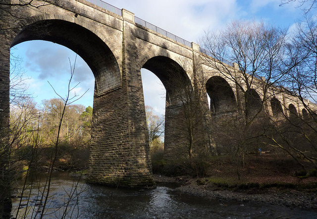
English: Avon Aqueduct This photo shows seven of the twelve arches of the Avon Aqueduct, which carries the Union Canal across the River Avon. At 247 metres long and 25.9 metres high, it is the longest and highest aqueduct in Scotland and the second longest in the UK. It was built between 1819 and 1822 by Hugh Baird (1770-1827), to a design by Thomas Telford (1757-1834) and, unusually, has a towpath on each side. |
| Date | |
| Source | From geograph.org.uk |
| Author | Eileen Henderson |
| Attribution (required by the license) InfoField | Eileen Henderson / Avon Aqueduct / |
InfoField | Eileen Henderson / Avon Aqueduct |
| Camera location | 55° 57′ 50″ N, 3° 39′ 25″ W | View this and other nearby images on: OpenStreetMap |
|---|
| Object location | 55° 57′ 49″ N, 3° 39′ 25″ W | View this and other nearby images on: OpenStreetMap |
|---|
Licensing

|
This image was taken from the Geograph project collection. See this photograph's page on the Geograph website for the photographer's contact details. The copyright on this image is owned by Eileen Henderson and is licensed for reuse under the Creative Commons Attribution-ShareAlike 2.0 license.
|
This file is licensed under the Creative Commons Attribution-Share Alike 2.0 Generic license.
Attribution: Eileen Henderson
- You are free:
- to share – to copy, distribute and transmit the work
- to remix – to adapt the work
- Under the following conditions:
- attribution – You must give appropriate credit, provide a link to the license, and indicate if changes were made. You may do so in any reasonable manner, but not in any way that suggests the licensor endorses you or your use.
- share alike – If you remix, transform, or build upon the material, you must distribute your contributions under the same or compatible license as the original.
Captions
Add a one-line explanation of what this file represents
Items portrayed in this file
depicts
some value
31 January 2010
55°57'49.79"N, 3°39'24.84"W
55°57'49.0"N, 3°39'25.2"W
image/jpeg
ddc06f10f6a57f822792a56934d61d3fde6d6687
122,089 byte
442 pixel
640 pixel
File history
Click on a date/time to view the file as it appeared at that time.
| Date/Time | Thumbnail | Dimensions | User | Comment | |
|---|---|---|---|---|---|
| current | 02:49, 5 March 2011 | | 640 × 442 (119 KB) | GeographBot | == {{int:filedesc}} == {{Information |description={{en|1=Avon Aqueduct This photo shows seven of the twelve arches of the Avon Aqueduct, which carries the Union Canal across the River Avon. At 247 metres long and 25.9 metres high, it is the longest and hi |
File usage
The following pages on the English Wikipedia use this file (pages on other projects are not listed):
Global file usage
The following other wikis use this file:
- Usage on arz.wikipedia.org
- Usage on ca.wikipedia.org
- Usage on ceb.wikipedia.org
- Usage on cs.wikipedia.org
- Usage on de.wikipedia.org
- Usage on eu.wikipedia.org
- Usage on nl.wikipedia.org
- Usage on www.wikidata.org
Metadata
This file contains additional information, probably added from the digital camera or scanner used to create or digitize it.
If the file has been modified from its original state, some details may not fully reflect the modified file.
| _error | 0 |
|---|