File:Arches_National_Park_Map.jpg
From Wikipedia, the free encyclopedia
Size of this preview: 400 × 600 pixels. Other resolutions: 160 × 240 pixels | 320 × 480 pixels | 512 × 768 pixels | 682 × 1,024 pixels | 2,500 × 3,750 pixels.
Original file (2,500 × 3,750 pixels, file size: 3.52 MB, MIME type: image/jpeg)
| This is a file from the Wikimedia Commons. Information from its description page there is shown below. Commons is a freely licensed media file repository. You can help. |
| This is a featured picture, which means that members of the community have identified it as one of the finest images on the English Wikipedia, adding significantly to its accompanying article. If you have a different image of similar quality, be sure to upload it using the proper free license tag, add it to a relevant article, and nominate it. |
| This image was selected as picture of the day on the English Wikipedia for October 8, 2008. |
|
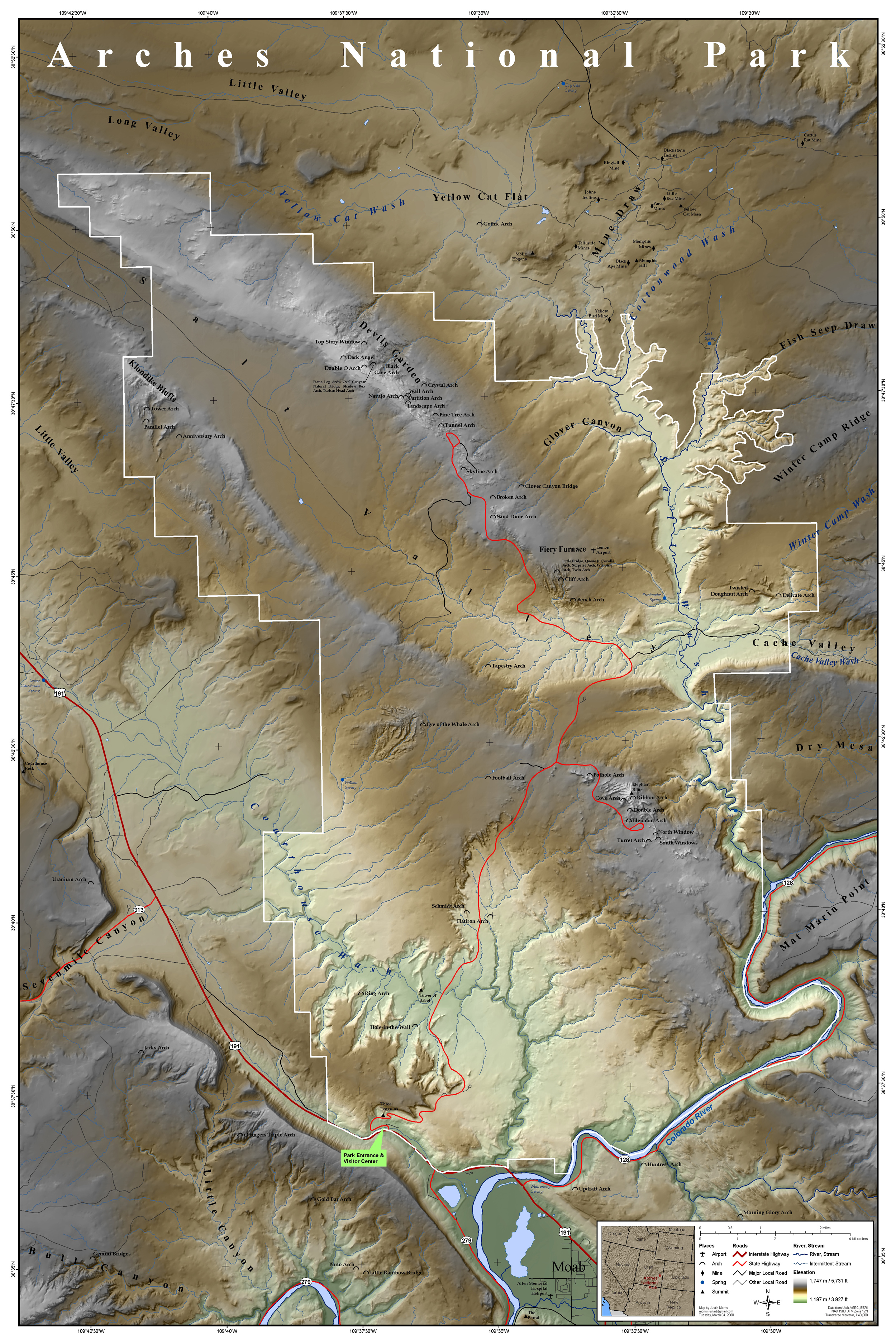
| DescriptionArches National Park Map.jpg | Map of Arches National Park, Utah, United States showing predominant features such as arches, peaks, rivers and streams, mines, and roads. | ||
| Date | |||
| Source | This map was entirely self made using ArcGIS. Map data is from Utah AGRC, ESRI and the USGS. | ||
| Author | Justinmorris (talk) | ||
| Permission (Reusing this file) |
I, the copyright holder of this work, hereby publish it under the following license: This file is licensed under the Creative Commons Attribution-Share Alike 3.0 Unported license.
|
Captions
Add a one-line explanation of what this file represents
Items portrayed in this file
depicts
some value
2 March 2008
image/jpeg
6bfc5ae0649ecee6a12cdbe4188d2324b70875f7
3,686,988 byte
3,750 pixel
2,500 pixel
File history
Click on a date/time to view the file as it appeared at that time.
| Date/Time | Thumbnail | Dimensions | User | Comment | |
|---|---|---|---|---|---|
| current | 17:15, 16 March 2008 | | 2,500 × 3,750 (3.52 MB) | Justinmorris | {{FeaturedPicture|Arches National Park Map}} == Summary == {{Information |Description=Map of Arches National Park, Utah, United States showing predominant features such as arches, peaks, rivers and streams, mines, and roads. |S |
File usage
The following pages on the English Wikipedia use this file (pages on other projects are not listed):
- Arches National Park
- User:Justinmorris
- User:Justinmorris/Maps
- User talk:Justinmorris
- User talk:Justinmorris/Archive01
- Wikipedia:Featured picture candidates/Arches National Park Map
- Wikipedia:Featured picture candidates/March-2008
- Wikipedia:Featured pictures/Diagrams, drawings, and maps/Maps
- Wikipedia:Featured pictures thumbs/11
- Wikipedia:Picture of the day/October 2008
- Wikipedia:Picture peer review/Arches National Park Map
- Wikipedia:Picture peer review/Archives/Jan-Mar 2008
- Wikipedia:WikiProject United States/Featured pictures
- Wikipedia:WikiProject United States/Quality content
- Wikipedia:WikiProject United States/Recognized content
- Wikipedia:Wikipedia Signpost/2008-03-17/Features and admins
- Wikipedia:Wikipedia Signpost/2008-03-17/SPV
- Wikipedia:Wikipedia Signpost/Single/2008-03-17
- Template:POTD/2008-10-08
- Portal:Maps/Selected picture
- Portal:Maps/Selected picture/39
- Portal:North America/Selected picture
- Portal:North America/Selected picture/32
- Portal:Utah
- Portal:Utah/Featured content
Global file usage
The following other wikis use this file:
- Usage on fr.wikipedia.org
- Usage on he.wikipedia.org
- Usage on is.wikipedia.org
- Usage on kw.wikipedia.org
- Usage on ml.wikipedia.org
- Usage on tr.wikipedia.org
- Usage on zh.wikipedia.org
Metadata
This file contains additional information, probably added from the digital camera or scanner used to create or digitize it.
If the file has been modified from its original state, some details may not fully reflect the modified file.
| Orientation | Normal |
|---|---|
| Horizontal resolution | 150 dpi |
| Vertical resolution | 150 dpi |
| Software used | Adobe Photoshop CS3 Macintosh |
| File change date and time | 19:03, 5 March 2008 |
| Color space | Uncalibrated |