File:American_Revolutionary_War_Cobleskill_and_Cherry_Valley.jpg
From Wikipedia, the free encyclopedia
Size of this preview: 800 × 531 pixels. Other resolutions: 320 × 212 pixels | 640 × 425 pixels | 1,024 × 679 pixels | 1,280 × 849 pixels | 2,086 × 1,384 pixels.
Original file (2,086 × 1,384 pixels, file size: 543 KB, MIME type: image/jpeg)
| This is a file from the Wikimedia Commons. Information from its description page there is shown below. Commons is a freely licensed media file repository. You can help. |
Summary
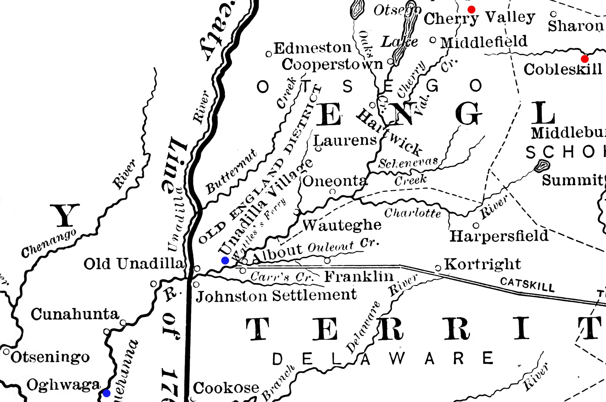
| DescriptionAmerican Revolutionary War Cobleskill and Cherry Valley.jpg | Detail from a map showing a portion of New York's western frontier with the Iroquois. The New York communities of Cherry Valley and Cobleskill, the scenes of military actions in the American Revolutionary War in 1778, are highlighted in red. The Indian villages of Unadilla and Unaquaga (spelled "Oghwaga" on the map), which were destroyed in raids in 1778, are highlighted in blue. |
| Date | published 1901 |
| Source | Derived from File:Frontier of NY in Revolution.png |
| Author | Image author not specified; book author Francis Whiting Halsey (1815-1919) |
Licensing
| Public domainPublic domainfalsefalse |
This media file is in the public domain in the United States. This applies to U.S. works where the copyright has expired, often because its first publication occurred prior to January 1, 1929, and if not then due to lack of notice or renewal. See this page for further explanation.
|
 | |
 |
This image might not be in the public domain outside of the United States; this especially applies in the countries and areas that do not apply the rule of the shorter term for US works, such as Canada, Mainland China (not Hong Kong or Macao), Germany, Mexico, and Switzerland. The creator and year of publication are essential information and must be provided. See Wikipedia:Public domain and Wikipedia:Copyrights for more details.
|
Captions
Add a one-line explanation of what this file represents
Items portrayed in this file
depicts
image/jpeg
d353c457e9354b70e4584e099fbfb4ac5bd8137b
555,531 byte
1,384 pixel
2,086 pixel
File history
Click on a date/time to view the file as it appeared at that time.
| Date/Time | Thumbnail | Dimensions | User | Comment | |
|---|---|---|---|---|---|
| current | 13:48, 14 February 2012 | | 2,086 × 1,384 (543 KB) | Magicpiano | bigger markers |
| 03:18, 29 January 2012 |  | 2,086 × 1,384 (543 KB) | Magicpiano | {{Information |Description=Detail from a map showing a portion of New York's western frontier with the Iroquois. The New York communities of Cherry Valley and Cobleskill, the scenes of mi |
File usage
The following pages on the English Wikipedia use this file (pages on other projects are not listed):
Global file usage
The following other wikis use this file:
- Usage on ja.wikipedia.org
- Usage on nl.wikipedia.org
- Usage on ru.wikipedia.org
- Usage on www.wikidata.org