File:Alberta_Towns.png
From Wikipedia, the free encyclopedia
Size of this preview: 355 × 600 pixels. Other resolutions: 142 × 240 pixels | 284 × 480 pixels | 454 × 768 pixels | 606 × 1,024 pixels | 1,741 × 2,941 pixels.
Original file (1,741 × 2,941 pixels, file size: 274 KB, MIME type: image/png)
| This is a file from the Wikimedia Commons. Information from its description page there is shown below. Commons is a freely licensed media file repository. You can help. |
Summary
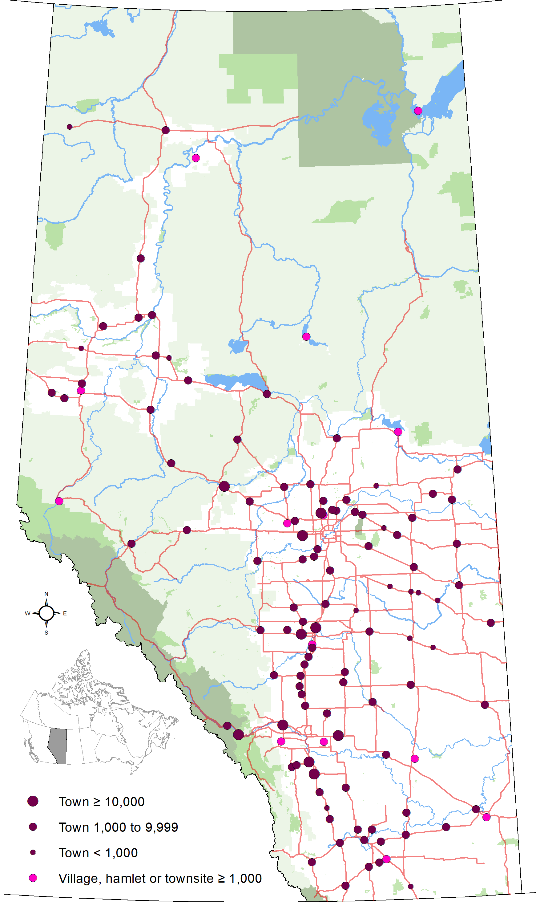
| DescriptionAlberta Towns.png |
English: Map showing locations of Alberta's 108 towns and town-equivalents (two villages, a townsite and nine hamlets with populations of 1,000 or greater) as of May 2013, with base reference features (major lakes and rivers, provincial 1-216 highway series, national parks, provincial protected areas and green and white areas). |
| Date | |
| Source | Own work |
| Author | Hwy43 |
Licensing
I, the copyright holder of this work, hereby publish it under the following license:
This file is licensed under the Creative Commons Attribution 3.0 Unported license.
- You are free:
- to share – to copy, distribute and transmit the work
- to remix – to adapt the work
- Under the following conditions:
- attribution – You must give appropriate credit, provide a link to the license, and indicate if changes were made. You may do so in any reasonable manner, but not in any way that suggests the licensor endorses you or your use.
Captions
Add a one-line explanation of what this file represents
Items portrayed in this file
depicts
18 July 2013
image/png
610285cbe38f41e8c90c496a7506a08133bd47ad
280,147 byte
2,941 pixel
1,741 pixel
File history
Click on a date/time to view the file as it appeared at that time.
| Date/Time | Thumbnail | Dimensions | User | Comment | |
|---|---|---|---|---|---|
| current | 00:14, 25 October 2020 | | 1,741 × 2,941 (274 KB) | Hwy43 | Update to late 2020. |
| 00:59, 1 August 2016 |  | 557 × 941 (64 KB) | Hwy43 | reflect that the Village of Thorsby now has a population of >1,000 | |
| 21:02, 29 December 2014 |  | 2,321 × 3,921 (371 KB) | Hwy43 | reflect that Chestermere to become a city on Jan-1/15 | |
| 07:28, 6 December 2013 |  | 1,741 × 2,941 (260 KB) | Hwy43 | population of Townsite of Redwood Meadows has dropped below 1,000 | |
| 05:54, 19 July 2013 |  | 1,741 × 2,941 (261 KB) | Hwy43 | User created page with UploadWizard |
File usage
The following pages on the English Wikipedia use this file (pages on other projects are not listed):
Global file usage
The following other wikis use this file:
- Usage on fr.wikipedia.org
- Usage on ku.wikipedia.org
Metadata
This file contains additional information, probably added from the digital camera or scanner used to create or digitize it.
If the file has been modified from its original state, some details may not fully reflect the modified file.
| Horizontal resolution | 118.11 dpc |
|---|---|
| Vertical resolution | 118.11 dpc |
Retrieved from "https://en.wikipedia.org/wiki/File:Alberta_Towns.png"