File:Alberta's_Cities.png
From Wikipedia, the free encyclopedia
Size of this preview: 355 × 600 pixels. Other resolutions: 142 × 240 pixels | 284 × 480 pixels | 454 × 768 pixels | 606 × 1,024 pixels | 1,741 × 2,941 pixels.
Original file (1,741 × 2,941 pixels, file size: 298 KB, MIME type: image/png)
| This is a file from the Wikimedia Commons. Information from its description page there is shown below. Commons is a freely licensed media file repository. You can help. |
Summary
| DescriptionAlberta's Cities.png |
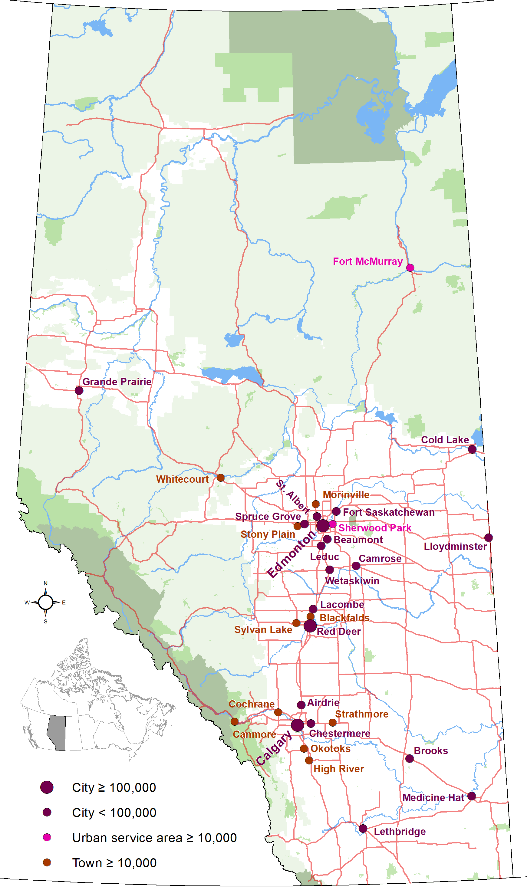
English: Map showing locations of Alberta 19 cities and city-equivalents (Fort McMurray and Sherwood Park urban service areas and towns with populations of 10,000 or greater) as of January 2019, with base reference features (major lakes and rivers, provincial 1-216 highway series, national parks, provincial protected areas and green and white areas). |
| Date | |
| Source | Own work |
| Author | Hwy43 |
Licensing
I, the copyright holder of this work, hereby publish it under the following license:
This file is licensed under the Creative Commons Attribution 3.0 Unported license.
- You are free:
- to share – to copy, distribute and transmit the work
- to remix – to adapt the work
- Under the following conditions:
- attribution – You must give appropriate credit, provide a link to the license, and indicate if changes were made. You may do so in any reasonable manner, but not in any way that suggests the licensor endorses you or your use.
Captions
Add a one-line explanation of what this file represents
Items portrayed in this file
depicts
19 July 2013
image/png
56245efad0cd42d6cfa8e59162378a2ea6a51b43
305,255 byte
2,941 pixel
1,741 pixel
File history
Click on a date/time to view the file as it appeared at that time.
| Date/Time | Thumbnail | Dimensions | User | Comment | |
|---|---|---|---|---|---|
| current | 00:07, 25 October 2020 | | 1,741 × 2,941 (298 KB) | Hwy43 | Update to show Morinville is now eligible for city status with a population greater than 10,000. |
| 06:49, 2 January 2019 |  | 1,741 × 2,941 (280 KB) | Hwy43 | uploading again (accidentally uploaded an updated towns map instead) | |
| 06:46, 2 January 2019 |  | 1,741 × 2,941 (262 KB) | Hwy43 | Update to reflect Beaumont's change to city status and the Town of Blackfalds surpassing the city status minimum population threshold in its 2018 municipal census | |
| 09:08, 27 December 2014 |  | 2,321 × 3,921 (392 KB) | Hwy43 | updated to reflect Chestermere's change from town status to city status effective January 1, 2015 | |
| 06:07, 19 July 2013 |  | 1,741 × 2,941 (277 KB) | Hwy43 | User created page with UploadWizard |
File usage
The following pages on the English Wikipedia use this file (pages on other projects are not listed):
Global file usage
The following other wikis use this file:
- Usage on azb.wikipedia.org
- Usage on fr.wikipedia.org
- Usage on is.wikipedia.org
- Usage on zh.wikipedia.org
Metadata
This file contains additional information, probably added from the digital camera or scanner used to create or digitize it.
If the file has been modified from its original state, some details may not fully reflect the modified file.
| Horizontal resolution | 118.11 dpc |
|---|---|
| Vertical resolution | 118.11 dpc |
Retrieved from "https://en.wikipedia.org/wiki/File:Alberta%27s_Cities.png"