File:Aegadian_Islands_map.png
From Wikipedia, the free encyclopedia
No higher resolution available.
Aegadian_Islands_map.png (690 × 528 pixels, file size: 112 KB, MIME type: image/png)
| This is a file from the Wikimedia Commons. Information from its description page there is shown below. Commons is a freely licensed media file repository. You can help. |
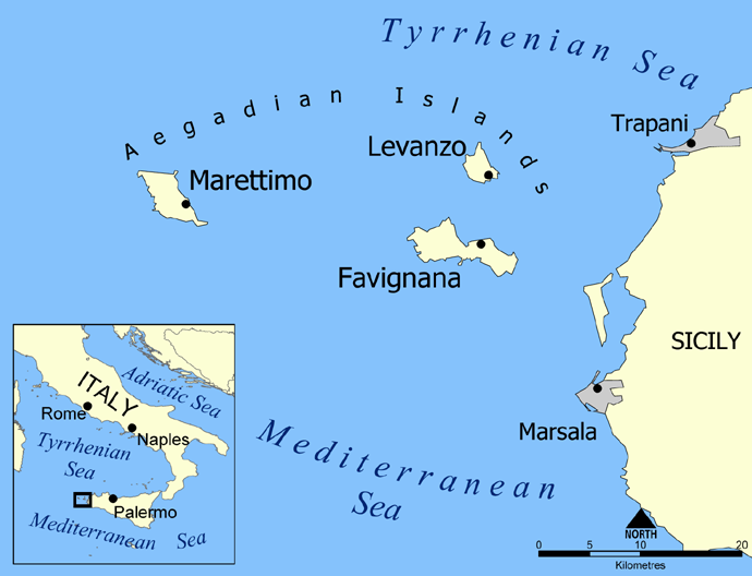
Map of the Aegadian Islands showing the islands of Favignana, Levanzo, and Marettimo, and the nearby port cities of Trapani and Marsala, Sicily.
Blank version available at Image:Aegadian Islands blank map.png.
Created by NormanEinstein, May 19, 2005.
| Public domainPublic domainfalsefalse |
| I, the copyright holder of this work, release this work into the public domain. This applies worldwide. In some countries this may not be legally possible; if so: I grant anyone the right to use this work for any purpose, without any conditions, unless such conditions are required by law. |
Captions
Add a one-line explanation of what this file represents
In dieser Datei abgebildete Objekte
depicts
image/png
89aaca308d8fbb1fa739b4a6e4c95f647ef575a1
114,279 byte
528 pixel
690 pixel
File history
Click on a date/time to view the file as it appeared at that time.
| Date/Time | Thumbnail | Dimensions | User | Comment | |
|---|---|---|---|---|---|
| current | 22:24, 26 February 2016 | | 690 × 528 (112 KB) | Ras67 | black frame removed, opt. |
| 13:58, 19 May 2005 |  | 700 × 538 (150 KB) | NormanEinstein | Map of the Aegadian Islands showing the islands of Favignana, Levanzo, and Marettimo, and the nearby port cities of Trapani and Marsala, Sicily. Created by NormanEinstein, May 19, 2005. {{PD-self}} |
File usage
The following pages on the English Wikipedia use this file (pages on other projects are not listed):
Global file usage
The following other wikis use this file:
- Usage on ar.wikipedia.org
- Usage on be.wikipedia.org
- Usage on bg.wikipedia.org
- Usage on bs.wikipedia.org
- Usage on ca.wikipedia.org
- Usage on cs.wikipedia.org
- Usage on da.wikipedia.org
- Usage on de.wikipedia.org
- Usage on el.wikipedia.org
- Usage on en.wiktionary.org
- Usage on eo.wikipedia.org
- Usage on fa.wikipedia.org
- Usage on fi.wikipedia.org
- Usage on fr.wikipedia.org
- Usage on fr.wiktionary.org
- Usage on fy.wikipedia.org
- Usage on gl.wikipedia.org
- Usage on he.wikipedia.org
- Usage on id.wikipedia.org
- Usage on it.wikipedia.org
- Usage on ja.wikipedia.org
- Usage on ka.wikipedia.org
View more global usage of this file.
Metadata
This file contains additional information, probably added from the digital camera or scanner used to create or digitize it.
If the file has been modified from its original state, some details may not fully reflect the modified file.
| Horizontal resolution | 59.06 dpc |
|---|---|
| Vertical resolution | 59.06 dpc |
Retrieved from "https://en.wikipedia.org/wiki/File:Aegadian_Islands_map.png"