File:Adrianople_Vilayet_—_Memalik-i_Mahruse-i_Shahane-ye_Mahsus_Mukemmel_ve_Mufassal_Atlas_(1907).jpg
From Wikipedia, the free encyclopedia
Size of this preview: 785 × 600 pixels. Other resolutions: 314 × 240 pixels | 628 × 480 pixels | 1,005 × 768 pixels | 1,280 × 978 pixels | 2,121 × 1,621 pixels.
Original file (2,121 × 1,621 pixels, file size: 1.77 MB, MIME type: image/jpeg)
| This is a file from the Wikimedia Commons. Information from its description page there is shown below. Commons is a freely licensed media file repository. You can help. |
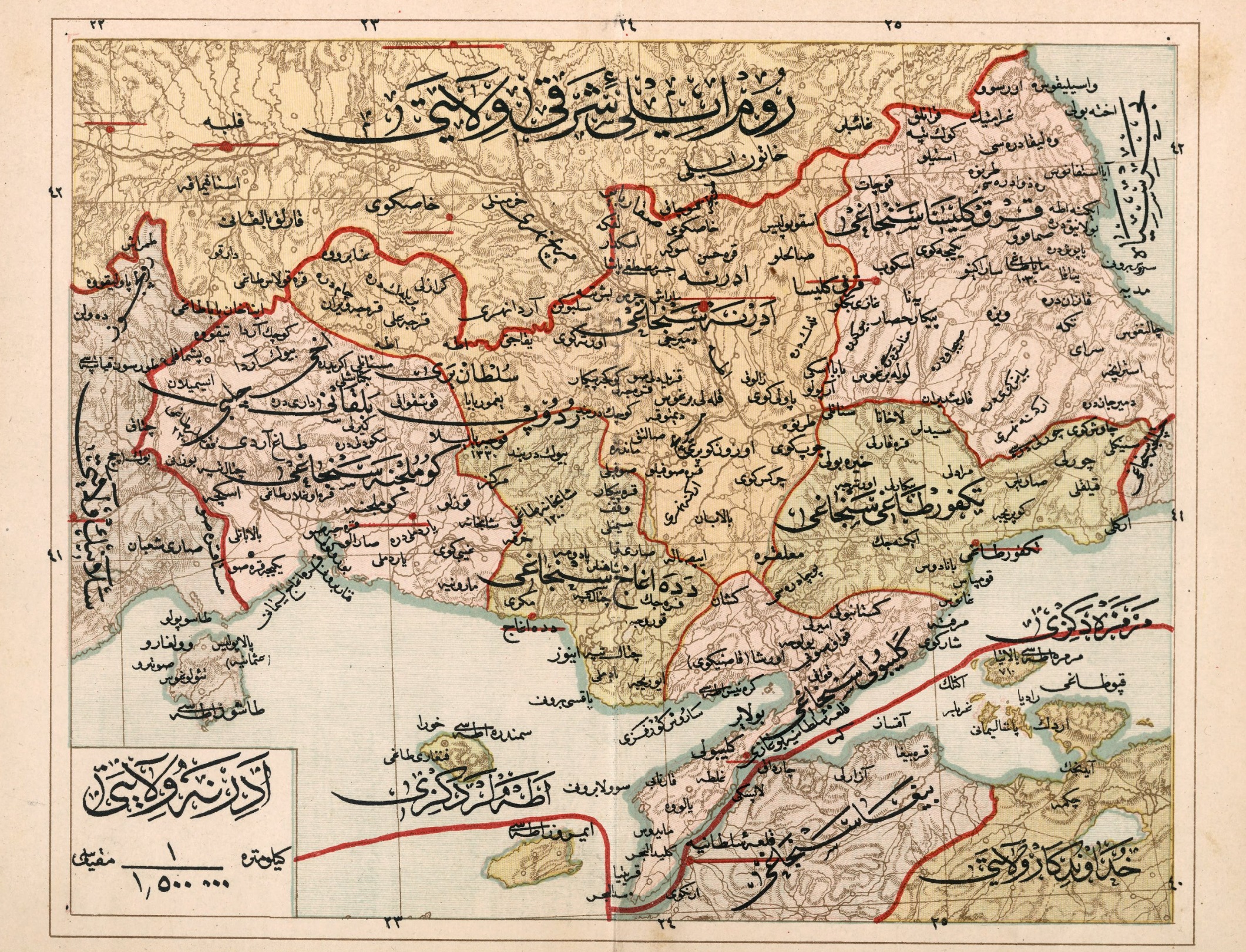
Summary
| DescriptionAdrianople Vilayet — Memalik-i Mahruse-i Shahane-ye Mahsus Mukemmel ve Mufassal Atlas (1907).jpg |
English: Adrianople Vilayet — Memalik-i Mahruse-i Şahaneye Mahsus Mukemmel ve Mufassal Atlas (1907); it was divided in five sanjaks: Edirne, Kirklaleri, Tekirdag, Callipoli, Alexandroupolis, and Komotini. |
| Date | |
| Source | http://www.bura.org.tr/haberler/haberoku.asp?hid=576 |
| Author | Mehmed Nasrullah, Mehmed Rüşdi, Mehmed Eşref |
Licensing
| Public domainPublic domainfalsefalse |
This media file is in the public domain in the United States. This applies to U.S. works where the copyright has expired, often because its first publication occurred prior to January 1, 1929, and if not then due to lack of notice or renewal. See this page for further explanation.
|
 | |
 |
This image might not be in the public domain outside of the United States; this especially applies in the countries and areas that do not apply the rule of the shorter term for US works, such as Canada, Mainland China (not Hong Kong or Macao), Germany, Mexico, and Switzerland. The creator and year of publication are essential information and must be provided. See Wikipedia:Public domain and Wikipedia:Copyrights for more details.
|
278
425
89
39
1100
859
Gümülcine
425
545
85
40
1100
859
Dedeağaç
885
464
95
40
1100
859
Tekirdağ
139
56
59
42
1100
859
Filibe
719
205
96
39
1100
859
Kırk Kilise
610
200
80
53
1100
859
Edirne
Captions
Add a one-line explanation of what this file represents
Items portrayed in this file
depicts
1907
image/jpeg
88fe8eee8efa006bdf68032c66526dc238a302e6
1,854,069 byte
1,621 pixel
2,121 pixel
File history
Click on a date/time to view the file as it appeared at that time.
| Date/Time | Thumbnail | Dimensions | User | Comment | |
|---|---|---|---|---|---|
| current | 02:10, 4 February 2023 | | 2,121 × 1,621 (1.77 MB) | BasilLeaf | Higher quality of the same map |
| 23:29, 1 October 2011 |  | 1,100 × 859 (289 KB) | Underlying lk | == Summary == {{Information |Description ={{en|1=Adrianople Vilayet — Memalik-i Mahruse-i Şahaneye Mahsus Mukemmel ve Mufassal Atlas (1907)}} |Source =http://www.aa.tufs.ac.jp/~kuroki/map/frameM.html |Author =Mehmed Nasrullah, Mehmed |
File usage
The following pages on the English Wikipedia use this file (pages on other projects are not listed):
Global file usage
The following other wikis use this file:
- Usage on ar.wikipedia.org
- Usage on bg.wikipedia.org
- Usage on el.wikipedia.org
- Usage on es.wikipedia.org
- Usage on fr.wikipedia.org
- Usage on it.wikipedia.org
- Usage on mk.wikipedia.org
- Usage on ru.wikipedia.org
- Usage on sq.wikipedia.org
- Usage on tr.wikipedia.org
- Usage on uk.wikipedia.org
Metadata
This file contains additional information, probably added from the digital camera or scanner used to create or digitize it.
If the file has been modified from its original state, some details may not fully reflect the modified file.
| Orientation | Normal |
|---|
.jpg)