File:9_dotted_line.png
From Wikipedia, the free encyclopedia
Size of this preview: 487 × 600 pixels. Other resolutions: 195 × 240 pixels | 390 × 480 pixels | 979 × 1,206 pixels.
Original file (979 × 1,206 pixels, file size: 1.79 MB, MIME type: image/png)
| This is a file from the Wikimedia Commons. Information from its description page there is shown below. Commons is a freely licensed media file repository. You can help. |
Summary
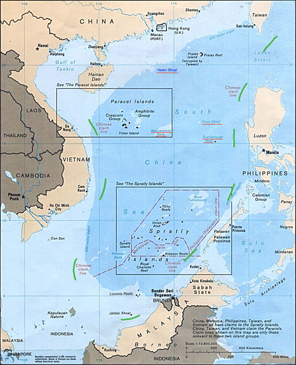
| Description9 dotted line.png |
English: Map of the South China Sea, with 9-dotted line highlighted in green |
| Date | |
| Source | Asia Maps — Perry-Castañeda Map Collection: South China Sea (Islands) 1988 |
| Author | U.S. Central Intelligence Agency |
| Other versions | file:Schina_sea_88.png |
Licensing
| Public domainPublic domainfalsefalse |
| This image is a work of a Central Intelligence Agency employee, taken or made as part of that person's official duties. As a Work of the United States Government, this image or media is in the public domain in the United States.
čeština ∙ Deutsch ∙ eesti ∙ English ∙ español ∙ français ∙ italiano ∙ português ∙ polski ∙ sicilianu ∙ slovenščina ∙ suomi ∙ Tiếng Việt ∙ български ∙ македонски ∙ русский ∙ українська ∙ বাংলা ∙ മലയാളം ∙ 한국어 ∙ 日本語 ∙ 中文 ∙ 中文(简体) ∙ 中文(繁體) ∙ العربية ∙ پښتو ∙ +/− |

|
Original upload log
The original description page was here. All following user names refer to en.wikipedia.
- 2011-10-20 18:05 JasonAQuest 979×1206× (1880133 bytes) {{Information |Description=Map of the South China Sea, with 9-dotted line highlighted in green |Source=[http://www.lib.utexas.edu/maps/asia.html Asia Maps — Perry-Castañeda Map Collection]: South China Sea (Islands) 1988 |Date=1988 |Author=U.S. Central Intelligence Agency |Permission={{PD-USGov-CIA}} |other_versions=Schina sea 88.png }} [[Category:South China Sea]] [[Category:Spratly Islands]] [[Category:Paracel Islands]]
Captions
Add a one-line explanation of what this file represents
Items portrayed in this file
depicts
1988
image/png
4ddef339c09aa57d57893efa2cde7ace1ddf4496
1,880,133 byte
1,206 pixel
979 pixel
File history
Click on a date/time to view the file as it appeared at that time.
| Date/Time | Thumbnail | Dimensions | User | Comment | |
|---|---|---|---|---|---|
| current | 22:29, 21 October 2011 | | 979 × 1,206 (1.79 MB) | Cantons-de-l'Est | {{Information |Description={{en|Map of the South China Sea, with 9-dotted line highlighted in green<br/> en:Category:South China Sea en:Category:Spratly Islands en:Category:Paracel Islands}} |Source=Transferred from [http://en.wikipedia. |
File usage
The following pages on the English Wikipedia use this file (pages on other projects are not listed):
Global file usage
The following other wikis use this file:
- Usage on ar.wikipedia.org
- Usage on az.wikipedia.org
- Usage on ca.wikipedia.org
- Usage on cs.wikipedia.org
- Usage on de.wikipedia.org
- Usage on es.wikipedia.org
- Usage on it.wikipedia.org
- Usage on ja.wikipedia.org
- Usage on ko.wikipedia.org
- Usage on no.wikipedia.org
- Usage on pl.wikipedia.org
- Usage on pt.wikipedia.org
- Usage on ru.wikipedia.org
- Usage on sv.wikipedia.org
- Usage on ta.wikipedia.org
- Usage on th.wikipedia.org
- Usage on tr.wikipedia.org
- Usage on uk.wikipedia.org
- Usage on www.wikidata.org
- Usage on zh.wikipedia.org
- Usage on zh.wikinews.org
Metadata
This file contains additional information, probably added from the digital camera or scanner used to create or digitize it.
If the file has been modified from its original state, some details may not fully reflect the modified file.
| Horizontal resolution | 28.35 dpc |
|---|---|
| Vertical resolution | 28.35 dpc |
Retrieved from "https://en.wikipedia.org/wiki/File:9_dotted_line.png"