File:2008_Sichuan_Earthquake_aftershockes_through_May_28.pdf
From Wikipedia, the free encyclopedia

Size of this JPG preview of this PDF file: 463 × 599 pixels. Other resolutions: 185 × 240 pixels | 371 × 480 pixels | 593 × 768 pixels | 1,275 × 1,650 pixels.
Original file (1,275 × 1,650 pixels, file size: 1.29 MB, MIME type: application/pdf)
| This is a file from the Wikimedia Commons. Information from its description page there is shown below. Commons is a freely licensed media file repository. You can help. |
Summary
| Description2008 Sichuan Earthquake aftershockes through May 28.pdf |
English: Map showing the location of the 2008 Sichuan earthquake and all the aftershocks following it through May 28, 2008 |
| Date | |
| Source | USGS |
| Author | USGS |
| Permission (Reusing this file) |
Public Domain |
Licensing
| Public domainPublic domainfalsefalse |
This image is in the public domain in the United States because it only contains materials that originally came from the United States Geological Survey, an agency of the United States Department of the Interior. For more information, see the official USGS copyright policy.
Bahasa Indonesia ∙ català ∙ čeština ∙ Deutsch ∙ eesti ∙ English ∙ español ∙ français ∙ galego ∙ italiano ∙ Nederlands ∙ português ∙ polski ∙ sicilianu ∙ suomi ∙ Tiếng Việt ∙ Türkçe ∙ български ∙ македонски ∙ русский ∙ മലയാളം ∙ 한국어 ∙ 日本語 ∙ 中文 ∙ 中文(简体) ∙ 中文(繁體) ∙ العربية ∙ فارسی ∙ +/− |
Original upload log
The original description page was here. All following user names refer to en.wikipedia.
- 2008-06-09 20:51 Cyclonebiskit 1275×1650× (1352464 bytes) {{Information |Description=Map showing the location of the 2008 Sichuan eathquake and all the aftershocks following it through May 28, 2008 |Source=[https://earthquake.usgs.gov/eqcenter/eqinthenews/2008/us2008ryan/#summary USGS] |Date=2008-6-1 |Author=USGS
Captions
Add a one-line explanation of what this file represents
Items portrayed in this file
depicts
1 June 2008
application/pdf
c9cf3ab60e6d6cebc7f69977ad3fd75d611df5af
1,352,464 byte
1,650 pixel
1,275 pixel
File history
Click on a date/time to view the file as it appeared at that time.
| Date/Time | Thumbnail | Dimensions | User | Comment | |
|---|---|---|---|---|---|
| current | 21:55, 13 April 2014 | 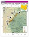 | 1,275 × 1,650 (1.29 MB) | The Bushranger | Transferred from en.wikipedia |
File usage
The following pages on the English Wikipedia use this file (pages on other projects are not listed):
Global file usage
The following other wikis use this file:
- Usage on fi.wikipedia.org
- Usage on id.wikipedia.org
- Usage on mt.wikipedia.org
- Usage on sh.wikipedia.org
- Usage on sl.wikipedia.org
- Usage on zh.wikipedia.org
Metadata
This file contains additional information, probably added from the digital camera or scanner used to create or digitize it.
If the file has been modified from its original state, some details may not fully reflect the modified file.
| Software used | ESRI ArcMap 9.2.4.1420 |
|---|---|
| Encrypted | no |
| Page size | 612 x 792 pts (letter) |
| Version of PDF format | 1.5 |