File:1960_Electoral_Map.png
From Wikipedia, the free encyclopedia
Size of this preview: 800 × 430 pixels. Other resolutions: 320 × 172 pixels | 640 × 344 pixels | 1,182 × 635 pixels.
Original file (1,182 × 635 pixels, file size: 179 KB, MIME type: image/png)
| This is a file from the Wikimedia Commons. Information from its description page there is shown below. Commons is a freely licensed media file repository. You can help. |
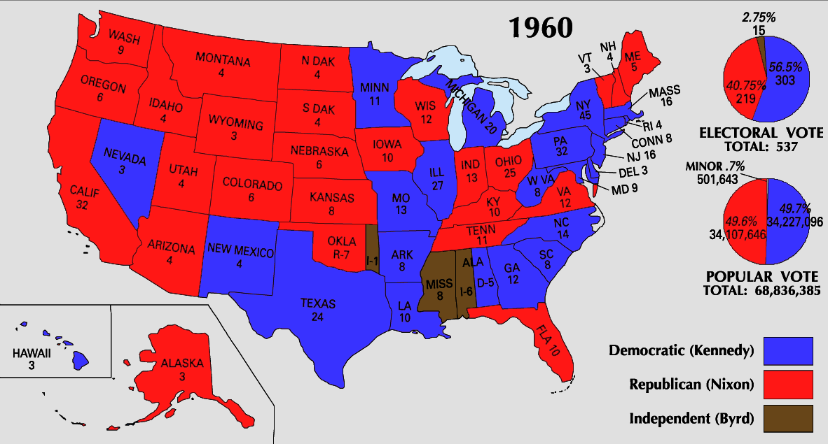
| U.S. presidential election maps from the National Atlas of the United States |
| See also: SVG maps |
| 1789 · 1792 · 1796 · 1800 · 1804 · 1808 · 1812 · 1816 · 1820 · 1824 · 1828 · 1832 · 1836 · 1840 · 1844 · 1848 · 1852 · 1856 · 1860 · 1864 · 1868 · 1872 · 1876 · 1880 · 1884 · 1888 · 1892 · 1896 · 1900 · 1904 · 1908 · 1912 · 1916 · 1920 · 1924 · 1928 · 1932 · 1936 · 1940 · 1944 · 1948 · 1952 · 1956 · 1960 · 1964 · 1968 · 1972 · 1976 · 1980 · 1984 · 1988 · 1992 · 1996 · 2000 · 2004 |
Summary
| Description1960 Electoral Map.png |
English: 1960 Electoral College Map |
| Source | https://nationalmap.gov/small_scale/printable/elections.html |
| Author | United States Geological Survey |
Licensing
| Public domainPublic domainfalsefalse |
This map was obtained from an edition of the National Atlas of the United States. Like almost all works of the U.S. federal government, works from the National Atlas are in the public domain in the United States.
Online access: NationalAtlas.gov | 1970 print edition: Library of Congress, Perry-Castañeda Library čeština | Deutsch | English | français | Bahasa Indonesia | italiano | македонски | മലയാളം | sicilianu | 中文 | 中文(简体) | 中文(繁體) | +/− |
Captions
Add a one-line explanation of what this file represents
Items portrayed in this file
depicts
image/png
8d765c3cfd5096a315f24d36d32e89684cebe595
183,295 byte
635 pixel
1,182 pixel
File history
Click on a date/time to view the file as it appeared at that time.
| Date/Time | Thumbnail | Dimensions | User | Comment | |
|---|---|---|---|---|---|
| current | 22:16, 25 June 2008 | | 1,182 × 635 (179 KB) | Tallicfan20 | |
| 21:44, 25 June 2008 |  | 1,182 × 635 (179 KB) | Tallicfan20 | better coloring | |
| 06:36, 30 May 2008 |  | 1,182 × 635 (164 KB) | Tallicfan20 | ||
| 17:31, 24 May 2008 |  | 1,182 × 635 (165 KB) | Tallicfan20 | better coloring | |
| 17:38, 16 May 2008 |  | 1,182 × 635 (109 KB) | Tallicfan20 | {{Information |Description=1960 Electoral College Map |Source=National Atlas |Date=5/16/2008 |Author=National Atlas |Permission=PD |other_versions= }} {{PD-USGov-Atlas}} |
File usage
The following pages on the English Wikipedia use this file (pages on other projects are not listed):
Global file usage
The following other wikis use this file:
- Usage on hu.wikipedia.org
- Usage on sv.wikipedia.org
- Usage on uk.wikipedia.org
Metadata
This file contains additional information, probably added from the digital camera or scanner used to create or digitize it.
If the file has been modified from its original state, some details may not fully reflect the modified file.
| Horizontal resolution | 28.35 dpc |
|---|---|
| Vertical resolution | 28.35 dpc |
Retrieved from "https://en.wikipedia.org/wiki/File:1960_Electoral_Map.png"