File:1941年到1942年二戰歐洲戰場局勢.png
From Wikipedia, the free encyclopedia
Size of this preview: 654 × 600 pixels. Other resolutions: 262 × 240 pixels | 523 × 480 pixels | 837 × 768 pixels | 1,090 × 1,000 pixels.
Original file (1,090 × 1,000 pixels, file size: 293 KB, MIME type: image/png)
| This is a file from the Wikimedia Commons. Information from its description page there is shown below. Commons is a freely licensed media file repository. You can help. |
| Annotations InfoField | This image is annotated: View the annotations at Commons |
92
927
13
13
1090
1000
Given its strategic importance, Gibraltar should be included as well.
Summary
| Description1941年到1942年二戰歐洲戰場局勢.png |
Deutsch: Karte der vom Deutschen Reich besetzten Gebiete und der Kriegsfronten im Zweiten Weltkrieg, 1941/42.
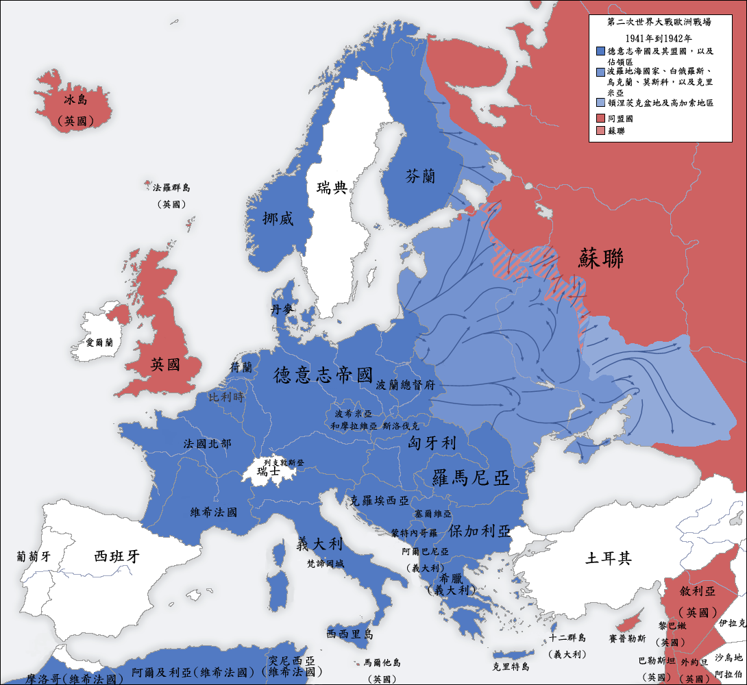
English: A map of German front of the Second World War circa 1941-1942.
Ελληνικά: Εδαφικές κατακτήσεις του Ράιχ
Español: Conquistas territoriales del Reich
中文(臺灣):1941年到1942年間,二戰歐洲戰場的局勢圖。 |
|||
| Date | ||||
| Source |
|
|||
| Author | San Jose, Yenhochia | |||
| Other versions |
[edit]
|


Licensing
I, the copyright holder of this work, hereby publish it under the following license:
This file is licensed under the Creative Commons Attribution-Share Alike 4.0 International license.
- You are free:
- to share – to copy, distribute and transmit the work
- to remix – to adapt the work
- Under the following conditions:
- attribution – You must give appropriate credit, provide a link to the license, and indicate if changes were made. You may do so in any reasonable manner, but not in any way that suggests the licensor endorses you or your use.
- share alike – If you remix, transform, or build upon the material, you must distribute your contributions under the same or compatible license as the original.
Captions
Add a one-line explanation of what this file represents
1941年到1942年二戰歐洲戰場局勢
Items portrayed in this file
depicts
6 October 2019
image/png
68efb66ab4e7aec8cb042127d06b9c99311ba773
299,949 byte
1,000 pixel
1,090 pixel
File history
Click on a date/time to view the file as it appeared at that time.
| Date/Time | Thumbnail | Dimensions | User | Comment | |
|---|---|---|---|---|---|
| current | 17:39, 5 October 2019 | | 1,090 × 1,000 (293 KB) | Yenhochia | User created page with UploadWizard |
File usage
No pages on the English Wikipedia use this file (pages on other projects are not listed).
Global file usage
The following other wikis use this file:
- Usage on zh.wikipedia.org
Metadata
This file contains additional information, probably added from the digital camera or scanner used to create or digitize it.
If the file has been modified from its original state, some details may not fully reflect the modified file.
| Horizontal resolution | 28.35 dpc |
|---|---|
| Vertical resolution | 28.35 dpc |
Retrieved from "https://en.wikipedia.org/wiki/File:1941年到1942年二戰歐洲戰場局勢.png"